Las Cabañas Bridge
Appearance
Las Cabañas Bridge | |
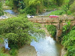
 The Las Cabañas Bridge in 2017 | |
| Location | Spanning the Río de las Vacas on Highway 135, km 82.4 Barrios Capáez and Juan González,[a] Adjuntas municipality Puerto Rico |
|---|---|
| Coordinates | 18°10′47″N 66°44′11″W / 18.179664°N 66.736422°W |
| Area | 235.2 m2 (2,532 sq ft)[1] |
| Built | 1919 |
| Built by | Félix Benítez Rexach |
| Engineer | Rafael Nones |
| MPS | Historic Bridges of Puerto Rico MPS[1] |
| NRHP reference No. | 95000838 |
| RNSZH No. | 2000-(RC)-22-JP-SH |
| Significant dates | |
| Added to NRHP | July 19, 1995 |
| Designated RNSZH | March 15, 2001 |
The Las Cabañas Bridge (Spanish: Puente de Las Cabañas) is a historic highway bridge in Adjuntas municipality, Puerto Rico. Built in 1919 to provide access to a key coffee-producing region, it was financed by nearby plantations through public subscription. Designer Rafael Nones and builder Félix Benítez Rexach, two of the most prominent figures in Puerto Rican bridge construction in the early 20th century, used a unique combination of steel and concrete technologies to produce a girder design unlike any other on the island and possibly beyond.[1]
The bridge was added to the U.S. National Register of Historic Places in 1995,[6] and to the Puerto Rico Register of Historic Sites and Zones in 2001.[7]
See also
[edit]Notes
[edit]References
[edit]- ^ a b c d Pumarada O'Neill, Luis (July 31, 1994), National Register of Historic Places Registration Form: Las Cabañas Bridge (PDF), retrieved February 22, 2016.
- ^ Departamento de Transportación y Obras Públicas (n.d.), Nuestros Puentes Históricos: Puentes de Otros Tipos [Our Historic Bridges: Bridges of Other Types] (in Spanish), archived from the original on April 27, 2010, retrieved February 24, 2016.
- ^ Oficina Estatal de Conservación Histórica (April 1, 2014), Puente de Las Cabañas (PDF) (summary sheet), retrieved February 24, 2016.
- ^ Oficina Estatal de Conservación Histórica (n.d.), Puerto Rico: Registro Nacional de Lugares Históricos [Puerto Rico: National Register of Historic Places] (online GIS), retrieved February 24, 2016.
- ^ Junta de Planificación (March 2009), Limites legales: Barrios [Legal boundaries: Barrios] (KML), retrieved February 24, 2016.
- ^ National Park Service (July 28, 1995), Weekly List of Actions Taken on Properties: 7/17/95 through 7/21/95 (PDF), p. 45, retrieved February 23, 2016.
- ^ GOBIERNO DE PUERTO RICO, JUNTA DE PLANIFICACIÓN DE PUERTO RICO (December 7, 2022). "REGISTRO DE PROPIEDADES DESIGNADAS POR LA JUNTA DE PLANIFICACIÓN DE PUERTO RICO" (PDF). jp.pr.gov.
External links
[edit]- Summary sheet from the Puerto Rico State Historic Preservation Office (in Spanish)
- National Register of Historic Places photographic file
- Historic Bridges of Puerto Rico MPS, National Register of Historic Places cover documentation
Categories:
- Road bridges on the National Register of Historic Places in Puerto Rico
- Bridges completed in 1919
- Adjuntas, Puerto Rico
- Girder bridges in the United States
- Steel bridges in the United States
- Concrete bridges in the United States
- 1919 establishments in Puerto Rico
- Puerto Rico Registered Historic Place stubs
- Puerto Rican building and structure stubs


