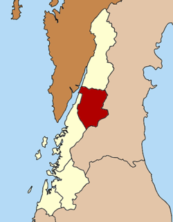
La-un district
La-un
ละอุ่น | |
|---|---|
 Kraburi River from Bang Kaeo | |
 District location in Ranong province | |
| Coordinates: 10°6′54″N 98°45′0″E / 10.11500°N 98.75000°E | |
| Country | Thailand |
| Province | Ranong |
| Seat | La-un Tai |
| Area | |
• Total | 748.5 km2 (289.0 sq mi) |
| Population (2023)[1] | |
• Total | 15,240 |
| • Density | 20/km2 (50/sq mi) |
| Time zone | UTC+7 (ICT) |
| ISO 3166 code | TH-8502 |
| Postal code | 85130 |
La-un (Thai: ละอุ่น, pronounced [lā.ʔùn]) is a district (amphoe) of Ranong province, southern Thailand.
History
[edit]In 1932 the minor district (king amphoe) was established as a subordinate of Mueang Ranong district. On 28 June 1973, it was upgraded to a full district.[2] In 1996, a new district office was built.
Geography
[edit]Neighboring districts are (from the north clockwise) Kra Buri of Ranong Province, Sawi, Lang Suan and Phato of Chumphon province, and Mueang Ranong of Ranong. To the west across the estuary of the Kraburi River is the Tanintharyi Division of Myanmar.
Administration
[edit]Provincial government
[edit]The district is divided into seven subdistricts (tambons), which are further subdivided into 30 villages (muban).[1]
| No. | Subdistricts | Thai | Villages | Pop. |
|---|---|---|---|---|
| 1. | La-un Tai | ละอุ่นใต้ | 6 | 1,661 |
| 2. | La-un Nuea | ละอุ่นเหนือ | 5 | 1,177 |
| 3. | Bang Phra Tai | บางพระใต้ | 3 | 968 |
| 4. | Bang Phra Nuea | บางพระเหนือ | 5 | 3,624 |
| 5. | Bang Kaew | บางแก้ว | 5 | 4,612 |
| 6. | Nai Wong Nuea | ในวงเหนือ | 3 | 1,669 |
| 7. | Nai Wong Tai | ในวงใต้ | 3 | 1,529 |
| Total | 30 | 15,240 |

Local government
[edit]La-un is a subdistrict municipality (thesaban tambon) and covers subdistricts La-un Tai and Bang Phra Tai. There are further three subdistrict administrative organizations - SAO (ongkan borihan suan tambon - o bo to): Bang Kaew and Bang Phra Nuea cover the whole subdistricts, La-un Nuea covers the three subdistricts La-un Nuea, Nai Wong Nuea and Nai Wong Tai.[1]
| La-un subdistrict municipality | Pop. | tesabanlaun |
| La-un Tai | 1,661 | |
| Bang Phra Tai | 968 | |
| Total | 2,629 |
| La-un Nuea - SAO | Pop. | launnuae |
| La-un Nuea | 1,177 | |
| Nai Wong Nuea | 1,669 | |
| Nai Wong Tai | 1,529 | |
| Total | 4,375 |
| Subd.adm.org-SAO | Pop. | website |
|---|---|---|
| Bangkaew SAO | 4,612 | bangkaew |
| Bang Phra Nuea SAO | 3,624 | bangphranuae |
References
[edit]- ^ a b c "Official statistics registration systems". Department of Provincial Administration. Retrieved 6 January 2025, year 2023 >village level >ExcelFile >no.8501-8599 >Excel line 85759-85992
{{cite web}}: CS1 maint: postscript (link) - ^ พระราชกฤษฎีกาตั้งอำเภอเขาพนม อำเภอสนามชัยเขต อำเภอแม่อาย อำเภอขามสะแกแสง อำเภอเก้าเลี้ยว อำเภอโพธิ์ประทับช้าง อำเภอหนองพอก อำเภอละอุ่น อำเภอทุ่งหว้า และอำเภอศรีธาตุ พ.ศ. ๒๕๑๖ (PDF). Royal Gazette (in Thai). 90 (75 ก special): 32–36. June 28, 1973. Archived from the original (PDF) on February 24, 2012.
Page Template:Asbox/styles.css has no content.
