Kfar Kidde
Appearance
Kfar Kidde, Kafr Kiddah, or Kfar Kiddé
كفر كدّه | |
|---|---|
 | |
| Country | |
| Governorate | Keserwan-Jbeil |
| District | Byblos |
| Elevation | 232 m (764 ft) |
| Population (1996) | |
• Total | 20,000+ |
| Time zone | +2 |
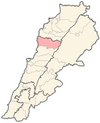
34°12′10″N 35°39′16″E / 34.20278°N 35.65444°E Kfar Kidde (Arabic: كفر كدّه) is a town in Northern Lebanon, roughly 51 km North of Beirut.[1] It is in the Byblos District of Keserwan-Jbeil Governorate, located along the Mediterranean coast.[2]
Notes
[edit]

