Kazaly
Appearance
Kazaly
Қазалы | |
|---|---|
Town | |
 | |
| Coordinates: 45°46′N 62°06′E / 45.767°N 62.100°E | |
| Country | Kazakhstan |
| Region | Kyzylorda |
| District | Kazaly |
| Population (2009) | |
• Total | 7,686 |
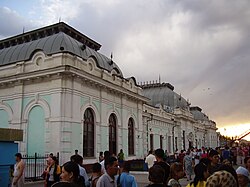
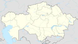
Kazaly (Kazakh: Қазалы, Qazaly), also known as Kazalinsk (Russian: Казалинск) is a town in Kazaly District of Kyzylorda Region in Kazakhstan, located on the right bank of the Syr Darya River. Population: 7,686 (2009 Census results);[1] 7,298 (1999 Census results).[1]
It is a closed area and for travelers, a special permission is required to visit the town.[2]
History
[edit]During the Russian conquest of Central Asia, Kazalinsk was founded in 1853 as a fort and granted town status in 1867.
According to Eugene Schuyler, it was located "at the junction of all the trade routes in Central Asia, as the road from Orenburg meets here with the Khiva, Bokhara and Tashkent roads."[3]
Climate
[edit]| Climate data for Kazaly (1991–2020, extremes 1855–present) | |||||||||||||
|---|---|---|---|---|---|---|---|---|---|---|---|---|---|
| Month | Jan | Feb | Mar | Apr | May | Jun | Jul | Aug | Sep | Oct | Nov | Dec | Year |
| Record high °C (°F) | 12.0 (53.6) |
21.1 (70.0) |
31.0 (87.8) |
36.6 (97.9) |
41.6 (106.9) |
43.6 (110.5) |
45.2 (113.4) |
43.4 (110.1) |
41.7 (107.1) |
34.1 (93.4) |
26.3 (79.3) |
14.0 (57.2) |
44.5 (112.1) |
| Mean daily maximum °C (°F) | −4.9 (23.2) |
−2.3 (27.9) |
7.8 (46.0) |
19.1 (66.4) |
26.7 (80.1) |
32.0 (89.6) |
33.5 (92.3) |
31.8 (89.2) |
25.2 (77.4) |
16.7 (62.1) |
5.3 (41.5) |
−2.4 (27.7) |
15.7 (60.3) |
| Daily mean °C (°F) | −8.9 (16.0) |
−7.2 (19.0) |
2.0 (35.6) |
12.5 (54.5) |
20.0 (68.0) |
25.4 (77.7) |
26.9 (80.4) |
24.7 (76.5) |
17.5 (63.5) |
9.3 (48.7) |
0.2 (32.4) |
−6.5 (20.3) |
9.7 (49.5) |
| Mean daily minimum °C (°F) | −12.8 (9.0) |
−11.7 (10.9) |
−3.1 (26.4) |
5.9 (42.6) |
12.8 (55.0) |
17.8 (64.0) |
19.5 (67.1) |
17.3 (63.1) |
10.4 (50.7) |
2.8 (37.0) |
−4.3 (24.3) |
−10.2 (13.6) |
3.7 (38.7) |
| Record low °C (°F) | −39.0 (−38.2) |
−36.1 (−33.0) |
−30.0 (−22.0) |
−12.2 (10.0) |
−1.7 (28.9) |
3.0 (37.4) |
7.8 (46.0) |
5.0 (41.0) |
−3.2 (26.2) |
−13.4 (7.9) |
−32.2 (−26.0) |
−41.1 (−42.0) |
−41.1 (−42.0) |
| Average precipitation mm (inches) | 12 (0.5) |
10 (0.4) |
14 (0.6) |
20 (0.8) |
14 (0.6) |
6 (0.2) |
6 (0.2) |
5 (0.2) |
3 (0.1) |
9 (0.4) |
13 (0.5) |
12 (0.5) |
124 (4.9) |
| Mean monthly sunshine hours | 123 | 158 | 192 | 254 | 338 | 374 | 390 | 369 | 301 | 220 | 137 | 105 | 2,961 |
| Source 1: Pogoda.ru.net[4] | |||||||||||||
| Source 2: NOAA (sun, 1961–1990)[5] | |||||||||||||
Notable people
[edit]- Agimsaly Duzelkhanov (1951-) – artist
- Roza Baglanova (1922–2011) – Soprano opera and pop vocalist
References
[edit]Wikimedia Commons has media related to Kazaly.
- ^ a b "Население Республики Казахстан" [Population of the Republic of Kazakhstan] (in Russian). Департамент социальной и демографической статистики. Retrieved 8 December 2013.
- ^ "Safety and security - Kazakhstan travel advice". GOV.UK. Retrieved 2023-05-04.
- ^ One or more of the preceding sentences incorporates text from a publication now in the public domain: Chisholm, Hugh, ed. (1911). "Kazala". Encyclopædia Britannica. Vol. 15 (11th ed.). Cambridge University Press. p. 703.
- ^ "Weather and Climate- The Climate of Kazalinsk" (in Russian). Weather and Climate (Погода и климат). Retrieved 4 January 2022.
- ^ "Kazalinsk (Kazaly) Climate Normals 1961–1990". National Oceanic and Atmospheric Administration. Retrieved 4 January 2022.

