Kampong Baroe
Appearance
Kampong Baroe | |
|---|---|
 Ferry Uitkijk (2000) | |
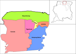
 Map showing the resorts of Saramacca District. Kampong Baroe | |
| Country | |
| District | Saramacca District |
| Area | |
• Total | 684 km2 (264 sq mi) |
| Elevation | 12 m (39 ft) |
| Population (2012)[1] | |
• Total | 2,248 |
| • Density | 3.3/km2 (8.5/sq mi) |
| Time zone | UTC-3 (AST) |
Kampong Baroe (Javanese: ꦏꦩ꧀ꦥꦸꦁꦧꦫꦸ; Standard Malay: Kampung Baru) is a resort in Suriname, located in the Saramacca District. Its population at the 2012 census was 2,248, the majority being Javanese, and East Indian.[1] The main agricultural crop is peanuts. Kampong Baroe also contains cattle, pig, and chicken farms.[2] "Kampong Baroe" in Malay language literally means "New Village" (Kampong: Village and Baru/Baroe: New).
Kampong Baroe has a clinic,[3] and a school.[2] On 23 March 2020, construction of a multi functional centre started.[4]
Other villages located in the resort are Boston, Uitkijk, Dam Parra, Totikamp, and Maho.
References
[edit]- ^ a b "Resorts in Suriname Census 2012" (PDF). Retrieved 18 May 2020.
- ^ a b "Structuur Analyse" (PDF). Planning Office Suriname (in Dutch). Retrieved 25 May 2020.
- ^ "Uitbreiding RGD-poli Kampong Baroe". GFC Nieuws (in Dutch). Retrieved 26 May 2020.
- ^ "Updates: bouw multifunctionele zaal Kampong Baroe per maandag 23 maart 2020". Suriname.nu (in Dutch). Retrieved 25 May 2020.
5°45′3″N 55°24′33″W / 5.75083°N 55.40917°W

