Istanbul Naval Museum
 Istanbul Naval Museum | |
 | |
| Established | 1897 |
|---|---|
| Location | Hayrettin İskelesi Sok. 80690 Beşiktaş, Istanbul, Turkey |
| Type | Naval museum |
| Website | denizmuzesi |
 |
| Components |
|---|
| History |
| Special Forces |
| Equipment |
The Istanbul Naval Museum (Turkish: İstanbul Deniz Müzesi) is a national naval museum, located in the Beşiktaş district of Istanbul, Turkey. It was established in 1897 by the Ottoman Minister of the Navy (Bahriye Nazırı) Bozcaadalı Hasan Hüsnü Pasha.[1][2]
The museum contains an important collection of military artifacts pertaining to the Ottoman Navy.[1] In the maritime field, it is Turkey's largest museum, with a great variety of collections. Around 20,000 pieces are present in its collection, including the late 16th or early 17th century Ottoman galley known as Tarihi Kadırga, built in the period between the reigns of Sultan Murad III (1574–1595) and Sultan Mehmed IV (1648–1687),[3][4] as evidenced by AMS radiocarbon dating and dendrochronological research.[4] She is the only surviving original galley in the world,[3][5] and has the world's oldest continuously maintained wooden hull.[6]
Being connected to the Turkish Naval Forces Command, it is also the country's first military museum.[7]
In the early 21st century a new exhibition building was constructed. The construction began in 2008, and the building was reopened on October 4, 2013. It has two floors above ground level and one basement floor, all covering 20,000 m2 (220,000 sq ft).[7]
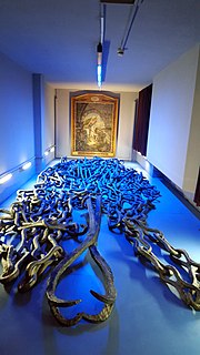
The basement consists of diverse items like figureheads, ornaments of naval ships, ship models, and pieces of the Byzantine chain that was used for blocking the entrance of the Golden Horn during the Ottoman conquest of Constantinople (Istanbul) in 1453. In the first and second floors, a large number of imperial and other caïques are exhibited.
Many exhibition items underwent special restoration and conservation works due to deformation of the raw materials caused by heat, light, humidity, atmospheric conditions, vandalism and other factors.[7]
Access
[edit]


The museum is located on Hayrettin İskelesi Street in Beşiktaş, Istanbul, near the Beşiktaş ferry pier for the Beşiktaş-Kadıköy line. The museum is open every day between 09:00 and 17:00, except for Mondays, New Year's Day and the first day of religious holidays.[7]
-
Naval cannons in the foyer
-
Imperial caïques
-
Bow ornaments of an imperial caïque
-
Stern ornaments of an imperial caïque
-
Ottoman ship figurehead lion
-
Ottoman ship figurehead lions
-
Ottoman ship figurehead lion
-
Ottoman ship figurehead
-
Ottoman ship figureheads
-
Ottoman ship ornament
-
Ottoman ship ornaments
-
Ottoman ship ornament
-
Broadside ornament of the Ottoman ironclad Orhaniye
-
Ornament of an imperial caique
-
Sergeant major of the Dockyard, Ottoman Navy
-
Galata Sergeant, Ottoman Navy
-
Painting of the Battle of Preveza (1538)
-
Istanbul Naval Museum, detail of the late 16th or early 17th century Ottoman Navy galley known as Tarihi Kadırga
-
Istanbul Naval Museum, detail of the late 16th or early 17th century Ottoman Navy galley known as Tarihi Kadırga
-
Istanbul Naval Museum, detail of the late 16th or early 17th century Ottoman Navy galley known as Tarihi Kadırga
-
Istanbul Naval Museum, detail of the late 16th or early 17th century Ottoman Navy galley known as Tarihi Kadırga
-
Istanbul Naval Museum, detail of the late 16th or early 17th century Ottoman Navy galley known as Tarihi Kadırga
-
Istanbul Naval Museum, detail of the late 16th or early 17th century Ottoman Navy galley known as Tarihi Kadırga
-
Istanbul Naval Museum, galley and caiques
-
Istanbul Naval Museum, galley and caiques
-
Istanbul Naval Museum, imperial caiques
-
Istanbul Naval Museum, imperial caique of Sultan Mehmed V
-
Istanbul Naval Museum, escutcheon detail
-
Istanbul Naval Museum, throne
-
Standard of Barbarossa Hayreddin Pasha
-
Model of the galley of Barbarossa Hayreddin Pasha during the Siege of Nice in 1543 and the Ottoman wintering in Toulon in 1543–44.
-
Model of Ottoman Navy flagship Mahmudiye (1829), a three-masted, three-decked, 128-gunned ship-of-the-line which was the world's largest battleship for many years.[9]
-
Types of artillery at the Istanbul Naval Museum
-
Propeller of the Ottoman battlecruiser TCG Yavuz, formerly SMS Goeben
-
Bust of Barbarossa Hayreddin Pasha
-
Bust of Turgut Reis
-
Bust of Piri Reis
-
Bust of Piyale Pasha
-
Busts of famous Ottoman admirals and seamen
-
Bust of Captain Hüseyin Rauf Orbay, Ottoman Minister of Navy and Turkish Prime Minister
-
Boats used by Mustafa Kemal Atatürk during his stay at the Florya Marine Mansion in Istanbul
See also
[edit]Notes
[edit]- ^ a b The World of Learning 2004 by Michael Salzman p.1670
- ^ "Archived copy". Archived from the original on 2012-09-30. Retrieved 2011-08-30.
{{cite web}}: CS1 maint: archived copy as title (link) - ^ a b "The Historical Galley". denizmuzesi.dzkk.tsk.tr. 2021-11-24. Archived from the original on 8 October 2021.
- ^ a b "Liphschitz, N., 2014. The Kadirga galley in Istanbul – The Turkish Sultan's Caique: A dendrohistorical research. In: Environment and Ecology in the Mediterranean Region II (eds. R. Efe and M. Ozturk). Cambridge Scholars Pub. Pp.39-48. Cambridge".
- ^ "Cornucopia Magazine". www.cornucopia.net. Retrieved 2022-03-16.
- ^ "Center for Maritime Archaeology and Conservation - Texas A&M University". nautarch.tamu.edu. Retrieved 2021-11-24.
- ^ a b c d "Main Page". Deniz Müzeleri. Archived from the original on 2014-11-11. Retrieved 2014-11-11.
- ^ "Gerçek ressamı bulundu". hurriyet.com.tr. Hürriyet. 6 July 2011.
- ^ Sondhaus, Lawrence (2001). Naval Warfare, 1815–1914. London: Routledge. p. 17. ISBN 978-0-415-21478-0.


![Model of Ottoman Navy flagship Mahmudiye (1829), a three-masted, three-decked, 128-gunned ship-of-the-line which was the world's largest battleship for many years.[9]](http://up.wiki.x.io/wikipedia/commons/thumb/f/fd/GaleonModel_IstanbulNavalMuseum.JPG/120px-GaleonModel_IstanbulNavalMuseum.JPG)


