Horsetail Falls (Oregon)
| Horsetail Falls | |
|---|---|
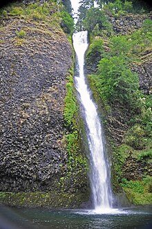 Horsetail Falls and pool | |
 | |
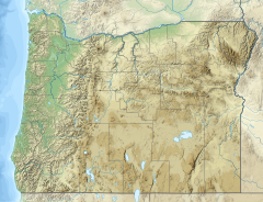
| Location | Columbia River Gorge |
| Coordinates | 45°35′23″N 122°04′07″W / 45.5896°N 122.0687°W |
| Type | Horsetail |
| Elevation | 224 ft (68 m) |
| Total height | 176 ft (54 m) |
| Number of drops | 1 |
| Average width | 15 ft (4.6 m) |
| Watercourse | Horsetail Creek |
Horsetail Falls (or Horse Tail Falls) is a waterfall located on Horsetail Creek along the Columbia River Gorge in Multnomah County, in the U.S. state of Oregon.[1] The falls drop over a cut over the columnar basalt cliff within the Oneonta Gorge.[2] It is one of the waterfalls along the Columbia River Highway's waterfall corridor.[3]
Access
[edit]The waterfall is easily accessed, in contrast to its near neighbor Oneonta Falls, as it is right next to the Historic Columbia River Highway. The shape of the falls and the rounded rockface over which it flows cause it to resemble a horse's tail.
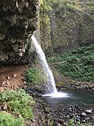
There are actually two waterfalls along the creek. The upper falls, called Upper Horsetail Falls or Ponytail Falls, can be accessed from a footpath. The path has steep cliffs and the U.S. Forest Service urges hikers to use caution when accessing the trails.[4]
Incidents
[edit]In May 2016, 37 year old Stephanie Cohen died after trying to rescue her son who had fallen when the footing on the trailhead gave way. She fell dozens of feet and was fatally injured. Her son recovered with minor injuries.[5]
In May 2024, 22 year old Elisha Angelic Macias was killed when she became separated from her hiking party and accidentally went off trail near the Oneonta Trail. She fell 50–60 feet and was fatally injured.[6]
Horsetail Falls Bridge
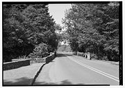
[edit]The Historic Columbia River Highway passes across Horsetail Falls on a bridge, the Horsetail Falls Bridge, which is listed on the National Register of Historic Places as a contributing structure.[7] It is a 60-foot (18 m) reinforced concrete slab span. The bridge was built in 1914 and is unique in its design in which it has been strengthened in 1998 from its original constitution by fibre-reinforced plastic.[8][9]
Gallery
[edit]-
Horsetail falls Bridge on the Historic Columbia River Highway
-
Ponytail falls
-
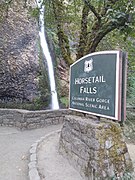
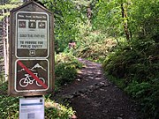
Horsetail falls road sign
-
Horsetail Falls Trail
See also
[edit]- List of bridges documented by the Historic American Engineering Record in Oregon
- List of bridges on the National Register of Historic Places in Oregon
References
[edit]- ^ "Horsetail Falls". World of Waterfalls. Retrieved September 14, 2022.
- ^ Williams, I. A. (1991). "The Columbia River Gorge; its geologic history interpreted from the Columbia River Highway" (PDF). Oregon Department of Geology and Mineral Industries Bulletin. 2 (3): 130.
- ^ "Horsetail Falls & Trail (#438)". USDA Forest Service. Retrieved September 14, 2022.
- ^ "Horsetail Falls & Trail (#438)". USDA US Forest Service. Retrieved December 6, 2024.
- ^ Ryan, Jim (May 22, 2016). "Horsetail Falls hiking death a grim reminder of outdoor dangers". The Oregonian/OregonLive. Retrieved December 6, 2024.
- ^ Urness, Zach. "Second hiker this spring dies from fall in Horsetail Falls area of Columbia River Gorge". Statesman Journal. Retrieved December 6, 2024.
- ^ Hadlow, Robert W. (February 4, 2000). "National Historic Landmark Nomination: Columbia River Highway / Historic Columbia River Highway". National Park Service. Retrieved January 12, 2022. With accompanying 33 photos
- ^ Seim, J. (September 1999). Composite strengthening and instrumentation of the Horsetail Falls Bridge with long gauge length fiber Bragg grating strain sensors. 13th International Conference on Optical Fiber Sensors. Vol. 3746. SPIE. pp. 172–175.
- ^ Soltesz, S. (2002). Strain monitoring for horsetail falls and sylvan bridges (No. FHWA-OR-DF-02-17) (Report). Oregon Department of Transportation.
External links
[edit]- Waterfalls of Oregon - Horsetail
- Historic American Engineering Record (HAER) No. OR-36-M, "Historic Columbia River Highway, Horsetail Falls Bridge, Spanning Horsetail Falls Creek, Troutdale, Multnomah County, OR", 1 photo, 13 data pages, 1 photo caption page

