Holland, Manitoba
Holland | |
|---|---|
| Village of Holland | |
 Emmanuel Anglican Church. | |
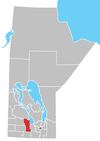
Location of Holland in Manitoba | |
| Coordinates: 49°35′40″N 98°52′52″W / 49.59444°N 98.88111°W | |
| Country | Canada |
| Province | Manitoba |
| Rural Municipality | Victoria |
| Established | 1878 |
| Government | |
| • MP (Portage—Lisgar) | Branden Leslie |
| • MLA (Spruce Woods) | Grant Jackson |
| Area | |
• Total | 2.70 km2 (1.04 sq mi) |
| Elevation | 380 m (1,250 ft) |
| Population (2021)[1] | |
• Total | 353 |
| • Density | 130/km2 (340/sq mi) |
| Time zone | UTC-6 (CST) |
| • Summer (DST) | UTC-5 (CDT) |
| Postal code span | |
| Area code | 204 |
| Demonym | Hollander |
Holland, Manitoba is an unincorporated community recognized as a local urban district[2] in the Rural Municipality of Victoria, in Manitoba.
It is located at the junction of Highway 2 and Highway 34, formerly along the Canadian Pacific Railway tracks.
It lies south of the Assiniboine River, at an elevation of 380 metres (1,250 ft). Spruce Woods Provincial Park is located north-west of the community.
Community facilities include an elementary school, a public library, fire department, a supermarket, a convenience store, a hardware, a post office and a medical clinic. A skating arena and curling rink are open during the winter months only. A farm machinery dealership lies opposite the town across Highway 2.
Residents of Holland are known as "Hollanders". Holland is the administrative centre of the surrounding municipality of Victoria and home to the LaSalle Redboine Conservation District and the Tiger Hills Arts Association.
Demographics
[edit]In the 2021 Census of Population conducted by Statistics Canada, Holland had a population of 354 living in 168 of its 190 total private dwellings, a change of 0% from its 2016 population of 354. With a land area of 2.7 km2 (1.0 sq mi), it had a population density of 131.1/km2 (339.6/sq mi) in 2021.[1]
Our Lady of the Prairies Monastery
[edit]Our Lady of the Prairies is a French Trappist monastery located near Rd 61 West and built from 1892 to 1918. It was designed by academic architect Jacques Collin, with assistance of Smith Carter Partners. The facility was known for its Oka cheese that was produced by monk Brother Albéric for 60+ years until 2018 when he retired. The monastery resides on 324 hectares of land, which includes the building itself, the farm that produces the cheese, and a small house where nuns and monks live.
In the following years, the surrounding farm land, the monastery site and its buildings were sold to Saint Mark’s Coptic Orthodox congregation located in Chevrier Boulevard in Winnipeg. In the fall of 2021, remains in the facility's cemetery were disinterred and moved to a cemetery in Rue des Ruines du Monastère.
As of July 2024, the monastery is now permanently closed, with members of the church's Sunday school visiting every few months ranging from grades 4-12. The owner of the congregation has changed the name to "St. Mary's Coptic Orthodox Monastery & Retreat Centre". All of the monks have left for good.
Notable people
[edit]- Glen Harmon, NHL all-star
- Ken Leishman, criminal known for robberies between 1957 and 1966
References
[edit]- ^ a b "Population and dwelling counts: Canada and designated places". Statistics Canada. February 9, 2022. Retrieved September 3, 2022.
- ^ "Local Urban Districts Regulation". Government of Manitoba. April 23, 2016. Retrieved April 24, 2016.


