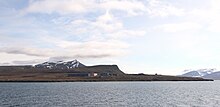
Heerodden
Appearance

Heerodden is a cape at the southern side of Isfjorden, on the eastern side of the outlet of Grønfjorden, in Nordenskiöld Land on Spitsbergen, Svalbard. It is named after Swiss paleobotanist Oswald Heer.[1] It is the site of Barentsburg Heliport, Heerodden.[2]
References
[edit]- ^ "Heerodden (Svalbard)". Norwegian Polar Institute. Retrieved 4 March 2013.
- ^ Arctic Pilot: Sailing directions Svalbard–Jan Mayen. Vol. 7. Stavanger: The Norwegian Hydrographic Service and The Norwegian Polar Institute. 1988. pp. 225–226. ISBN 82-90653-06-9.
78°06′14″N 14°11′50″E / 78.1038°N 14.1971°E
