Hallelujah Peak
Appearance
| Hallelujah Peak | |
|---|---|
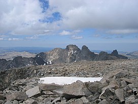
 From the summit of Cloud Peak, left to right, Black Tooth Mountain, Mount Woolsey and Hallelujah Peak at far right. | |
| Highest point | |
| Elevation | 12,594 ft (3,839 m)[1] |
| Prominence | 350 ft (110 m)[1] |
| Coordinates | 44°24′32″N 107°10′10″W / 44.40889°N 107.16944°W[1] |
| Geography | |
| Location | Johnson County, Wyoming, U.S. |
| Parent range | Bighorn Mountains |
| Topo map | USGS Cloud Peak |
| Climbing | |
| First ascent | 11 July 1933, W. B. Willcox and Alan Willcox[2] |
Hallelujah Peak (12,594 feet (3,839 m)), also known as Peak 12590, is located in the Bighorn Mountains in the U.S. state of Wyoming.[3] The peak is the fifth-highest in the range and it is in the Cloud Peak Wilderness of Bighorn National Forest.[4] Hallelujah Peak is 0.64 miles (1.03 km) northeast of Black Tooth Mountain and connected to that peak by a knife-like ridge known as an arête.[1]
The first recorded ascent was made by W. B. Willcox and his brother Alan Willcox.[2]
References
[edit]- ^ a b c d "Peak 12590, Wyoming". Peakbagger.com. Retrieved October 5, 2014.
- ^ a b Willcox, W.B. "An American Tyrol, Climbs in the Bighorns 1933". American Alpine Club. Retrieved October 5, 2014.
- ^ Cloud Peak, WY (Map). TopoQwest (United States Geological Survey Maps). Retrieved October 5, 2014.
- ^ "Central Bighorn Mountains". Peakbagger.com. Retrieved October 5, 2014.


