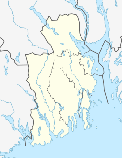
Gullhaug, Vestfold
Appearance
Gullhaug | |
|---|---|
Village | |
| Coordinates: 59°30′10″N 10°14′58″E / 59.50286°N 10.24952°E | |
| Country | Norway |
| Region | Eastern Norway |
| County | Vestfold |
| District | Jarlsberg |
| Municipality | Holmestrand Municipality |
| Area | |
• Total | 1.38 km2 (0.53 sq mi) |
| Elevation | 139 m (456 ft) |
| Population (2024)[1] | |
• Total | 2,604 |
| • Density | 1,882/km2 (4,870/sq mi) |
| Time zone | UTC+01:00 (CET) |
| • Summer (DST) | UTC+02:00 (CEST) |
| Post Code | 3089 Holmestrand |
Gullhaug is a village in Holmestrand Municipality in Vestfold county, Norway. The village is located about 3 kilometres (1.9 mi) to the northwest of the town of Holmestrand and about 7 kilometres (4.3 mi) to the southeast of the village of Sundbyfoss. The European route E18 highway passes by the village about 2 kilometres (1.2 mi) to the west. The village is mainly a residential area.[3]
The 1.38-square-kilometre (340-acre) village has a population (2024) of 2,604 and a population density of 1,882 inhabitants per square kilometre (4,870/sq mi).[1]
References
[edit]- ^ a b c Statistisk sentralbyrå (1 January 2023). "Urban settlements. Population and area, by municipality".
- ^ "Gullhaug, Holmestrand". yr.no. Retrieved 21 March 2024.
- ^ Lundbo, Sten, ed. (17 January 2024). "Gullhaug (tettsted i Holmestrand)". Store norske leksikon (in Norwegian). Kunnskapsforlaget. Retrieved 21 March 2024.


