Guangyuan
Guangyuan
广元市 | |
|---|---|
 | |
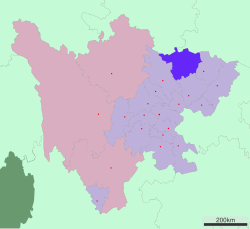
 Location of Guangyuan in Sichuan | |
| Coordinates (Guangyuan municipal government): 32°26′10″N 105°50′38″E / 32.436°N 105.844°E | |
| Country | People's Republic of China |
| Province | Sichuan |
| Municipal seat | Lizhou District |
| Area | |
• Total | 16,313.78 km2 (6,298.79 sq mi) |
| Population (2020) | |
• Total | 2,305,657 |
| • Density | 140/km2 (370/sq mi) |
| GDP[1] | |
| • Total | CN¥ 60.5 billion US$ 9.7 billion |
| • Per capita | CN¥ 23,263 US$ 3,735 |
| Time zone | UTC+8 (China Standard) |
| Postal code | 628017 |
| Area code | 0839 |
| ISO 3166 code | CN-SC-08 |
| Website | www |
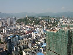
Guangyuan (simplified Chinese: 广元; traditional Chinese: 廣元; pinyin: Guǎngyuán; Wade–Giles: Kuang-yüan) is a prefecture-level city in Sichuan Province, China, bordering the provinces of Shaanxi to the northeast and Gansu to the northwest. The city has a population of 2,305,657 as of the 2020 census.[2]
Located roughly between the provincial capitals Chengdu, Lanzhou, Xi'an and Chongqing municipality, it is considered the northern gateway to Sichuan.[3] It is an ancient city, notable for its relics and tombs.
History
[edit]Formerly known as Lizhou (利州, or Li prefecture), Guangyuan was the birthplace of Wu Zetian, the only woman in Chinese history to rule directly as emperor.[4]
On 12 May 2008, a magnitude 7.9 earthquake occurred. 4,822 people were killed, 28,245 injured, and 125 missing in the city as of 7 June 2008.[5]
Economy
[edit]Guangyuan's economy is based on a diverse array of heavy industry, as well as mining and agriculture.[citation needed] Plant 821, a former large plutonium producing reactor, now used to process nuclear waste, is located near Guangyuan.[6] The city is an important production center for traditional Chinese medicine.[7]
Administrative divisions
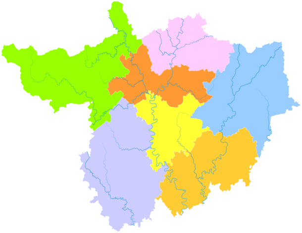
[edit]| Map | |||||
|---|---|---|---|---|---|
| Name | Hanzi | Hanyu Pinyin | Population (2010) | Area (km²) | Density (/km²) |
| Lizhou District | 利州区 | Lìzhōu Qū | 516,424 | 1,482 | 348 |
| Zhaohua District | 昭化区 | Zhāohuà Qū | 168,489 | 1,435 | 117 |
| Chaotian District | 朝天区 | Cháotiān Qū | 174,333 | 1,618 | 108 |
| Wangcang County | 旺苍县 | Wàngcāng Xiàn | 385,787 | 2,976 | 130 |
| Qingchuan County | 青川县 | Qīngchuān Xiàn | 222,253 | 3,269 | 68 |
| Jiange County | 剑阁县 | Jiàngé Xiàn | 457,656 | 3,204 | 142 |
| Cangxi County | 苍溪县 | Cāngxī Xiàn | 559,181 | 2,330 | 240 |
Climate
[edit]| Climate data for Guangyuan, elevation 545 m (1,788 ft), (1991–2020 normals, extremes 1981–present) | |||||||||||||
|---|---|---|---|---|---|---|---|---|---|---|---|---|---|
| Month | Jan | Feb | Mar | Apr | May | Jun | Jul | Aug | Sep | Oct | Nov | Dec | Year |
| Record high °C (°F) | 19.5 (67.1) |
26.0 (78.8) |
30.4 (86.7) |
34.4 (93.9) |
36.8 (98.2) |
38.7 (101.7) |
40.5 (104.9) |
40.9 (105.6) |
36.6 (97.9) |
31.0 (87.8) |
26.3 (79.3) |
19.2 (66.6) |
40.9 (105.6) |
| Mean daily maximum °C (°F) | 9.6 (49.3) |
12.4 (54.3) |
17.4 (63.3) |
23.4 (74.1) |
27.4 (81.3) |
30.1 (86.2) |
31.5 (88.7) |
31.2 (88.2) |
26.2 (79.2) |
21.2 (70.2) |
16.2 (61.2) |
10.8 (51.4) |
21.4 (70.6) |
| Daily mean °C (°F) | 5.4 (41.7) |
8.1 (46.6) |
12.3 (54.1) |
17.6 (63.7) |
21.7 (71.1) |
24.8 (76.6) |
26.5 (79.7) |
26.0 (78.8) |
21.6 (70.9) |
16.8 (62.2) |
11.8 (53.2) |
6.8 (44.2) |
16.6 (61.9) |
| Mean daily minimum °C (°F) | 2.4 (36.3) |
5.0 (41.0) |
8.5 (47.3) |
13.3 (55.9) |
17.2 (63.0) |
20.6 (69.1) |
22.8 (73.0) |
22.3 (72.1) |
18.6 (65.5) |
14.1 (57.4) |
8.7 (47.7) |
3.9 (39.0) |
13.1 (55.6) |
| Record low °C (°F) | −4.5 (23.9) |
−2.9 (26.8) |
−3.2 (26.2) |
2.7 (36.9) |
8.3 (46.9) |
14.5 (58.1) |
16.0 (60.8) |
15.0 (59.0) |
11.7 (53.1) |
1.7 (35.1) |
−0.8 (30.6) |
−5.7 (21.7) |
−5.7 (21.7) |
| Average precipitation mm (inches) | 4.7 (0.19) |
9.3 (0.37) |
17.5 (0.69) |
49.2 (1.94) |
90.5 (3.56) |
124.5 (4.90) |
247.1 (9.73) |
147.4 (5.80) |
138.0 (5.43) |
57.0 (2.24) |
19.3 (0.76) |
4.2 (0.17) |
908.7 (35.78) |
| Average precipitation days (≥ 0.1 mm) | 4.3 | 5.1 | 7.3 | 10.0 | 12.0 | 12.1 | 14.6 | 13.2 | 13.5 | 12.3 | 6.6 | 4.0 | 115 |
| Average snowy days | 2.5 | 1.0 | 0.2 | 0.1 | 0 | 0 | 0 | 0 | 0 | 0 | 0.2 | 0.8 | 4.8 |
| Average relative humidity (%) | 63 | 63 | 61 | 62 | 62 | 68 | 74 | 74 | 76 | 75 | 70 | 66 | 68 |
| Mean monthly sunshine hours | 71.4 | 68.4 | 98.5 | 132.3 | 147.7 | 133.1 | 140.2 | 155.1 | 86.7 | 79.4 | 78.0 | 76.1 | 1,266.9 |
| Percent possible sunshine | 22 | 22 | 26 | 34 | 34 | 31 | 32 | 38 | 24 | 23 | 25 | 25 | 28 |
| Source: China Meteorological Administration[8][9] all-time extreme temperature[10] | |||||||||||||
Transport
[edit]Located roughly between the provincial capitals Chengdu, Chongqing, Lanzhou, Xi'an, Guangyuan is an important traffic hub in northern Sichuan.[11] The city has a port on the Jialing River, which is the closest inland port to Northwest China, and navigable all the way the east coast.
- China National Highway 212
- G5 Beijing–Kunming Expressway
- G5012 Enguang Expressway
- G75 Lanzhou–Haikou Expressway
- Baoji–Chengdu railway (part of the main route from Chengdu to Xi'an and Beijing)
- Xi'an–Chengdu high-speed railway (completed in December 2017)
- Lanzhou–Chongqing high-speed railway
- Guangyuan Panlong Airport
Cuisine
[edit]Guangyuan is known for Wangcang noodles.[12]
References
[edit]- ^ 四川省统计局、国家统计局四川调查总队 (2016). 《四川统计年鉴-2016》. China Statistics Press. ISBN 978-7-5037-7871-1.
- ^ "广元市第七次全国人口普查公报". 17 June 2021.
- ^ Chris Parker. "Guangyuan--An up and coming tourist destination".
- ^ "Welcome to Guangyuan". Lonely Planet.
- ^ "Guangyuan Government Held 20th News Conference for the Earthquake on June 7" (in Chinese (China)). Official website of Guangyuan Government. 8 June 2008. Archived from the original on 20 June 2017. Retrieved 8 June 2008.
- ^ "广元821核军工厂的昨天与今天". xw.qq.com (in Chinese). Retrieved 1 December 2021.
- ^ "New Material Industry". The People's Government of Guangyuan.
- ^ 中国气象数据网 – WeatherBk Data (in Simplified Chinese). China Meteorological Administration. Retrieved 14 April 2023.
- ^ 中国气象数据网 (in Simplified Chinese). China Meteorological Administration. Retrieved 14 April 2023.
- ^ "Extreme Temperatures Around the World". Retrieved 20 November 2024.
- ^ "Endowed City Next To Shu Path".
- ^ "旺苍手工挂面-利州区人民政府". www.lzq.gov.cn. Retrieved 6 February 2021.


