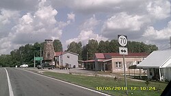
Griderville, Kentucky
Appearance
Griderville | |
|---|---|
 | |
| Coordinates: 37°06′46″N 85°52′13″W / 37.11278°N 85.87028°W | |
| Country | |
| State | |
| County | Barren |
| Elevation | 741 ft (226 m) |
| Time zone | UTC−6 (CST) |
| • Summer (DST) | UTC−5 (CDT) |
| ZIP codes | 42127 |
| GNIS feature ID | 508137[1] |
Griderville is a rural unincorporated community in northern Barren County, Kentucky, United States.[1][2]
History
[edit]This section needs expansion. You can help by adding to it. (October 2022) |
Geography
[edit]The community is located in the north-central portion of Barren County, at the junction of U.S. Route 31E and Kentucky Route 70.[3] US 31E leads south to Glasgow, and north to Hardyville and Hodgenville. KY 70 leads 4 miles (6.4 km) west to Cave City and the Mammoth Cave National Park, and east to Hiseville.
Post office
[edit]Griderville is currently served by the Cave City post office by default with ZIP code 42127.
References
[edit]- ^ a b "Griderville". Geographic Names Information System. United States Geological Survey, United States Department of the Interior.
- ^ "Griderville Populated Place Profile / Barren County, Kentucky Data". kentucky.hometownlocator.com. Retrieved February 22, 2019.
- ^ DeLorme (2010). Kentucky Atlas & Gazetteer (Map). 1:150000. Yarmouth, ME: DeLorme. p. 65. § F9. ISBN 0-89933-340-0.


