Fort Smith Airport
Appearance
Fort Smith Airport | |||||||||||||||
|---|---|---|---|---|---|---|---|---|---|---|---|---|---|---|---|
| Summary | |||||||||||||||
| Airport type | Public | ||||||||||||||
| Operator | Government of the Northwest Territories | ||||||||||||||
| Location | Fort Smith, Northwest Territories | ||||||||||||||
| Time zone | MST (UTC−07:00) | ||||||||||||||
| • Summer (DST) | MDT (UTC−06:00) | ||||||||||||||
| Elevation AMSL | 673 ft / 205 m | ||||||||||||||
| Coordinates | 60°01′13″N 111°57′43″W / 60.02028°N 111.96194°W | ||||||||||||||
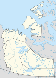
| Map | |||||||||||||||
 | |||||||||||||||
| Runways | |||||||||||||||
| |||||||||||||||
| Statistics (2010) | |||||||||||||||
| |||||||||||||||
Fort Smith Airport (IATA: YSM, ICAO: CYSM) is located near Fort Smith, Northwest Territories, Canada. Runway 03/21 has no winter service.
The Fort Smith (District) Heliport is located southeast of the airport.
Airlines and destinations
[edit]Passenger
[edit]| Airlines | Destinations |
|---|---|
| Northwestern Air | Edmonton, Fort Chipewyan, Hay River, High Level, Yellowknife (all end 16 January 2025)[4] |
Accidents and incidents
[edit]- On January 23, 2024, Northwestern Air Flight 738, a British Aerospace Jetstream operated by Northwestern Air as a charter flight to the Diavik Diamond Mine crashed shortly after takeoff, killing six people and injuring one.[5][6]
References
[edit]- ^ Canada Flight Supplement. Effective 0901Z 16 July 2020 to 0901Z 10 September 2020.
- ^ "Synoptic/Metstat Station Information". Archived from the original on December 1, 2011.
- ^ "Total aircraft movements by class of operation". www150.statcan.gc.ca. Retrieved 2024-01-24.
- ^ Pruys, Sarah; Williams, Ollie (18 December 2024). "Fort Smith's Northwestern to hand scheduled flights to Air Tindi". Cabin Radio. Retrieved 20 December 2024.
- ^ "BREAKING: Fatalities confirmed after aircraft crashes at Fort Smith". CKLB Radio. 23 January 2024. Retrieved 24 January 2024.
- ^ "6 people dead in Tuesday's plane crash near Fort Smith, N.W.T., says coroner". CBC News. 24 January 2024. Retrieved 24 January 2024.
External links
[edit]- Past three hours METARs, SPECI and current TAFs for Fort Smith Airport from Nav Canada as available.

