Forest and Frith
| Forest and Frith | |
|---|---|
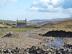
 Harwood Beck and hills | |
Location within County Durham | |
| Population | 163 (2011 census) |
| Civil parish |
|
| District | |
| Shire county | |
| Region | |
| Country | England |
| Sovereign state | United Kingdom |
Forest and Frith is a civil parish in the County Durham unitary authority, in the ceremonial county of Durham, England. In the 2011 census it had a population of 163.[1]
The parish has an area of 7,002 hectares (27.03 sq mi).[1] It is bordered by the parishes of Stanhope to the north, Newbiggin to the east, Holwick to the south east and Lunedale to the south, in County Durham,[2] and by the Eden District of Cumbria to the west, the western boundary being the River Tees and Cow Green Reservoir. The main settlements in the parish are Forest-in-Teesdale, Ettersgill, Harwood and Langdon Beck.[3]
The 1870-72 Imperial Gazetteer of England and Wales describes Forest and Frith as a township in Middleton-in-Teesdale of 17,270 acres (6,990 ha; 26.98 sq mi) with a population of 862 in 130 houses.[4] In 1866 it became a parish in its own right.[5]
It does not have a parish council but has a parish meeting.[6]
There are 10 listed buildings in the parish: a barn, 3 bridges, 5 milestones and a water wheel pit.[7] The parish lies within the North Pennines Area of Outstanding Natural Beauty.[8]

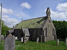
The church of St James the Less, Forest and Frith was built in 1845 and is off the B6277 road south of Langdon Beck.[9][10]
The word "Forest" in the name means open land used for hunting, as in Royal forest and New Forest, and "frith" means woodland, as in Chapel en le Frith.[11][12]
References
[edit]- ^ a b UK Census (2011). "Local Area Report – Forest and Frith Parish (E04010630)". Nomis. Office for National Statistics.
- ^ "Parish Boundary map". maps.durham.gov.uk. Durham County Council. Retrieved 30 March 2023.
- ^ "Forest and Frith Civil Parish". co-curate.ncl.ac.uk. Co-Curate. Retrieved 30 March 2023.
- ^ "Forest and Frith, County Durham". A vision of Britain through time. GB Historical GIS / University of Portsmouth. Retrieved 30 March 2023.
- ^ "Relationships and changes Forest and Frith Tn/CP through time". A Vision of Britain through Time. Retrieved 30 March 2023.
- ^ "Forest and Frith Parish Meeting". cdalc.info. County Durham Association of Local Councils. Retrieved 30 March 2023.
- ^ "Historic Buildings and Monuments in Forest and Frith". co-curate.ncl.ac.uk. Co-Curate. Retrieved 30 March 2023.
- ^ "Welcome to the North Pennines". North Pennines AONB. 25 November 2019. Retrieved 30 March 2023.
- ^ "St. James the Less Church, Forest with Frith, Middleton-in-Teesdale, Co Durham". Upper Teesdale Churches Together. Retrieved 30 March 2023.
- ^ "St James". www.achurchnearyou.com. Retrieved 30 March 2023.
- ^ "Teesdale history and scenery". England's North East. Retrieved 30 March 2023.
- ^ "Key to English Place-names: Forest and Frith". kepn.nottingham.ac.uk. Retrieved 30 March 2023.

