Durangaldea
You can help expand this article with text translated from the corresponding article in Spanish. (May 2024) Click [show] for important translation instructions.
|
Durangaldea | |
|---|---|
 | |
 | |
| Country | Spain |
| Autonomous community | Basque Country |
| Province | Biscay |
| Capital | Durango |
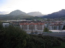
Durangaldea (Spanish: Duranguesado) is a comarca of Biscay located in the Basque Country, Spain. It is one of the seven eskualdeak/comarcas or regions that compose the province of Biscay. The capital city of Durangaldea is Durango.
Geography
[edit]
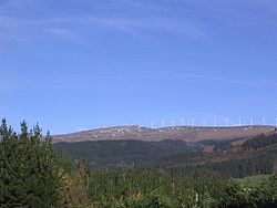
Durangaldea is located at the southeast of the province of Biscay, limiting with the provinces of Gipuzkoa and Álava. It spans the territory between Oiz mountain and the border with the province of Álava in the south. Its total area is 240.13 square kilometres (92.71 sq mi).
Most of the towns that compose the comarca are located on a great valley formed by the Ibaizabal river, that crosses it from east to west. Otxandio is the only town that belongs to Durangaldea but is not part of the valley.
History
[edit]Durangaldea (also known by its Spanish name, Duranguesado) was during the Middle Ages a district apart from Biscay (the Señorío) and a dependency of Navarre, but was conquered by Castile in 1200. It remained separate from Biscay until 1630, and it held its own compilation of laws, with its regional council joining in Gerediaga, Abadiño. Its lords founded four chartered towns, namely Ermua, Elorrio, Durango, and Otxandio.
Municipalities
[edit]
Durangaldea is divided into twelve municipalities, of which Durango is the capital city. The municipalities that compose the comarca are the same ones that made the merindad of Durango, the previous administrative division. Their areas and populations are set out below. Ermua and Mallabia belong to the province of Biscay, but administratively are not part of Durangaldea, being part of another comarca, Debabarrena, which is part of Gipuzkoa.
| # | Municipality | Population | Land area in km2 |
|---|---|---|---|
| Abadiño | 7,599 | 36.06 | |
| Amorebieta-Etxano | 19,329 | 58.46 | |
| Atxondo | 1,366 | 23.21 | |
| Berriz | 4,623 | 30.07 | |
| Durango | 29,729 | 10.91 | |
| Elorrio | 7,372 | 37.32 | |
| Garai | 327 | 7.12 | |
| Ermua | 15,880 | 6.49 | |
| Izurtza | 255 | 4.28 | |
| Iurreta | 3,662 | 18.84 | |
| Mallabia | 1,158 | 23.79 | |
| Mañaria | 515 | 17.73 | |
| Otxandio | 1,314 | 12.43 | |
| Zaldibar | 3,043 | 11.84 |
Economy
[edit]The economy of Durangaldea is mainly industrial, although the primary sector is also important.
Primary sector
[edit]It is the second most important sector of the economy in the region after the industry. The animal husbandry is specially important, as well as the wood production. The minery is also an important section of the economy, currently being produced limestone and marble. Mines of iron, lead and copper have also been exploited.
Secondary sector
[edit]The siderurgy has been one of the most developed type of industries in Durangaldea. Besides it, other industries like paper producers or tool producers also exist.
Transportation
[edit]Durangaldea is connected to the three Basque provinces by roads, Álava in the south by the BI-623 and Bilbao and Donostia by the road N-634. The Cantabric Highway also crosses the comarca, and can be accessed from Durango and connects the city with Bilbao, Donostia and the French border.
EuskoTren also operates in the region, offering commuter rail services. The train line connects with Bilbao and other comarcas of the province and also with Gipuzkoa. EuskoTren has train stations in Abadiño, Amorebieta-Etxano, Berriz, Durango and Zaldibar. The bus company BizkaiBus also operates in the region, connecting all the municipalities with others on different comarcas.
See also
[edit]
