Central District (Minudasht County)
Appearance
Central District (Minudasht County)
Persian: بخش مرکزی شهرستان مینودشت | |
|---|---|
| Coordinates: 37°08′33″N 55°23′27″E / 37.14250°N 55.39083°E[1] | |
| Country | Iran |
| Province | Golestan |
| County | Minudasht |
| Capital | Minudasht |
| Population (2016)[2] | |
• Total | 60,367 |
| Time zone | UTC+3:30 (IRST) |
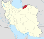
The Central District of Minudasht County (Persian: بخش مرکزی شهرستان مینودشت) is in Golestan province, Iran. Its capital is the city of Minudasht.[3]
History
[edit]After the 2006 National Census, Kuhsarat Rural District[a] was separated from the district in the formation of Kuhsarat District.[4] After the 2016 census, the village of Alqajar was elevated to the status of a city.[5]
Demographics
[edit]Population
[edit]At the time of the 2006 census, the district's population was 69,272 in 17,085 households.[6] The following census in 2011 counted 59,898 people in 16,606 households.[7] The 2016 census measured the population of the district as 60,367 inhabitants in 18,195 households.[2]
Administrative divisions
[edit]| Administrative Divisions | 2006[6] | 2011[7] | 2016[2] |
|---|---|---|---|
| Chehel Chay RD | 23,978 | 26,392 | 25,565 |
| Kuhsarat RD[a][b] | 14,139 | ||
| Qaleh Qafeh RD | 5,172 | 5,028 | 4,717 |
| Alqajar (city)[c] | |||
| Minudasht (city) | 25,983 | 28,478 | 30,085 |
| Total | 69,272 | 59,898 | 60,367 |
| RD = Rural District | |||
See also
[edit]Notes
[edit]- ^ a b Renamed Garu Rural District[4]
- ^ Transferred to Kuhsarat District
- ^ Became a city after the 2016 census[5]
References
[edit]- ^ OpenStreetMap contributors (18 October 2024). "Central District (Minudasht County)" (Map). OpenStreetMap (in Persian). Retrieved 18 October 2024.
- ^ a b c Census of the Islamic Republic of Iran, 1395 (2016): Golestan Province. amar.org.ir (Report) (in Persian). The Statistical Center of Iran. Archived from the original (Excel) on 29 March 2019. Retrieved 19 December 2022.
- ^ Habibi, Hassan (c. 2024) [Approved 21 June 1369]. Approval of the organization and chain of citizenship of the elements and units of the divisions of Mazandaran province, centered in Sari city. lamtakam.com (Report) (in Persian). Ministry of the Interior, Defense Political Commission of the Government Council. Subject Letter 3233.1.5.53; Notification 83346/T144K. Archived from the original on 14 January 2024. Retrieved 14 January 2024 – via Lam ta Kam.
- ^ a b Rahimi, Mohammad Reza. Divisional changes and reforms in Golestan province (Report) (in Persian). Ministry of the Interior – via qavanin.ir/Law/TreeText/?IDS=10503364040954659624 (Laws and Regulations Portal of the Islamic Republic of Iran).
H - Kuhsarat District centered on Dowzeyn village is created from the combination of Garu and Sar Gol Rural Districts in Minudasht County...
- ^ a b Mokhbar, Mohammad (22 September 2023) [Approved 31 March 1402]. The approval letter regarding the conversion of Alqajar village of Chehel Chay Rural District, Central District of Minudasht County, Golestan province, into a city. rrk.ir (Report) (in Persian). Ministry of the Interior, Council of Ministers. Archived from the original on 14 October 2023. Retrieved 17 October 2024.
- ^ a b Census of the Islamic Republic of Iran, 1385 (2006): Golestan Province. amar.org.ir (Report) (in Persian). The Statistical Center of Iran. Archived from the original (Excel) on 20 September 2011. Retrieved 25 September 2022.
- ^ a b Census of the Islamic Republic of Iran, 1390 (2011): Golestan Province. irandataportal.syr.edu (Report) (in Persian). The Statistical Center of Iran. Archived from the original (Excel) on 17 January 2023. Retrieved 19 December 2022 – via Iran Data Portal, Syracuse University.


