Cathedraltown
A major contributor to this article appears to have a close connection with its subject. (March 2018) |
Cathedraltown | |
|---|---|
Neighbourhood | |
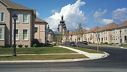
 The streetscape of Cathedraltown. | |
| Coordinates: 43°53′47″N 79°22′28″W / 43.8964°N 79.3744°W | |
| Country | Canada |
| Province | Ontario |
| Regional municipality | York |
| City | Markham |
| Established | 2006 |
| Population (2006 est.) | |
• Total | 3,000 |
| Time zone | UTC-5 (Eastern Standard Time (EST)) |
| • Summer (DST) | UTC-4 (Eastern Daylight Time (EDT)) |
| Area code(s) | 905 and 289 |
Cathedraltown is a planned neighbourhood with an estimated population of 3,000[1] in the City of Markham, just north of Toronto. Cathedraltown was named after the Cathedral of the Transfiguration, around which the neighbourhood was built.
Geography
[edit]Cathedraltown is bordered on the north to Major Mackenzie Drive, on the south to Elgin Mills Road, on the west to Victoria Square Boulevard, and on the east to Highway 404.
History
[edit]The land occupied by Cathedraltown was originally farmland owned by Romandale Farms, a breeder and exhibitor of Holstein cows. Stephen B. Roman, the late founder of Romandale Farms, built the Cathedral on land he donated. In the early 2000s, his daughter, Helen Roman-Barber, working with Donald Buttress, Surveyor of the Fabric Emeritus of Westminster Abbey, developed the design concept for Cathedraltown, based on European cathedral towns.[2]
The neighbourhood's first residents moved in by 2006 with the completion of homes north of the Cathedral. Since then, single- and multi-family housing and mixed-use condominiums have been built to the west and south of the Cathedral.[citation needed]
Architecture and art
[edit]
Designed under the direction of Donald Buttress, Cathedraltown reflects the Regency and Georgian architecture that was popular in London in the late 18th an early 19th centuries.
In July 2017 a statue of the cow Brookview Tony Charity was erected in Cathedraltown to some controversy. The statue is of a prize-winning cow that was owned jointly by Romandale Farms and Hanover Hill Farms, in the nearby town of Port Perry, where the cow resided. Romandale Farms donated the statue to honour Charity[3][4] In October 2017, Markham City Council voted to search for a new location for the statue.[5] As of May 2018[update], the statue has been taken down and placed in storage until a more suitable and accepted home for Charity can be found.[6]
Public transit
[edit]The following bus routes serve the neighbourhood:
- YRT Route #4 / 4A – Major MacKenzie
- YRT Route #24 – Woodbine
- YRT Route #25 – Major MacKenzie
- YRT Route #80 – Elgin Mills
- YRT Route #452 – Richmond Green School Special
- YRT Route #418 - Pierre Elliott Trudeau School Special
References
[edit]- ^ The population can only be estimated as the census tract is shared with other communities, and communities such as Cachet and Greensborough. Together, this census tract makes up a population of 5,414.
- ^ "Cathedraltown...suburbia with a twist". UrbanToronto.ca.
- ^ Wheeler, Scott (27 July 2017). "Cathedraltown cow just one of family developer's personal design cues". Toronto Star.
- ^ "Will controversial cow sculpture be moooved?". www.msn.com.
- ^ Javed, Noor (17 October 2017). "Markham cow statue to stay put, for now". The Toronto Star.
- ^ Anderson, Kalli (Jun 26, 2018). "Was a freak spring windstorm behind Charity the chrome cow's demise?". cbc.ca. Retrieved 2019-04-11.

