Broxa, North Yorkshire
| Broxa | |
|---|---|
 Looking south-east towards Broxa | |
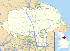
Location within North Yorkshire | |
| OS grid reference | SE945915 |
| Civil parish | |
| Unitary authority | |
| Ceremonial county | |
| Region | |
| Country | England |
| Sovereign state | United Kingdom |
| Post town | SCARBOROUGH |
| Postcode district | YO13 |
| Police | North Yorkshire |
| Fire | North Yorkshire |
| Ambulance | Yorkshire |
Broxa is a village in the civil parish of Broxa-cum-Troutsdale, in North Yorkshire, England, within the North York Moors National Park. The village is 6.2 miles (10 km) west of Scarborough, at an elevation of 531 feet (162 m). The River Derwent is 1,600 feet (500 m) west of the village.[1][2]
Whilst some 12th century documents mention Broxa (in relation to land granted by the abbot of Whitby), the village was not listed in the Domesday Book. It is thought that it was included in the manor of Hackness.[3] The name of the village derives from a personal name Broce, meaning the enclosure of Broce's people.[4]
Broxa was formerly a township in the parish of Hackness,[5] in 1866 Broxa became a separate civil parish,[6] on 1 April 1985 the parish was abolished to form "Broxa cum Troutsdale".[7] In 1971 the parish had a population of 15.[8] Until 1974 it was in the North Riding of Yorkshire. From 1974 to 2023 it was in Scarborough district.
To the north of the village is Broxa Forest, a 1,527 acres (618 ha) woodland maintained by Forestry England which has walking and cycling trails. The Moors to Sea Cycle route passes through the village and the forest.[9][10][11]
See also
[edit]References
[edit]- ^ "Broxa, Scarborough (YO13 0BP)". getoutside.ordnancesurvey.co.uk. Retrieved 9 September 2021.
- ^ "OL27" (Map). North York Moors - Eastern area. 1:25,000. Explorer. Ordnance Survey. 2017. ISBN 978-0-319-242667.
- ^ Clay, Charles Travis (2013). Early Yorkshire charters. Volume 11, The Percy fee. Cambridge: Cambridge University Press. p. 295. ISBN 1108058345.
- ^ Ekwall, Eilert (1960). The concise Oxford dictionary of English place-names (4 ed.). Oxford: Oxford University Press. p. 70. ISBN 0-19-869103-3.
- ^ "History of Broxa, in Scarborough and North Riding". A Vision of Britain through Time. Retrieved 22 May 2024.
- ^ "Relationships and changes Broxa CP/Tn through time". A Vision of Britain through Time. Retrieved 22 May 2024.
- ^ "Scarborough Registration District". UKBMD. Retrieved 22 May 2024.
- ^ "Population statistics Broxa CP/Tn through time". A Vision of Britain through Time. Retrieved 22 May 2024.
- ^ "Broxa". woodlandtrust.org.uk. Retrieved 9 September 2021.
- ^ "Broxa". forestryengland.uk. Retrieved 9 September 2021.
- ^ "4. Highwood Brow to Ravenscar". northyorkmoors.org.uk. Retrieved 9 September 2021.
External links
[edit]![]() Media related to Broxa, North Yorkshire at Wikimedia Commons
Media related to Broxa, North Yorkshire at Wikimedia Commons

