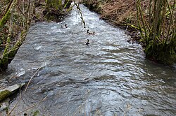
Brohlbach (Moselle)
Appearance
You can help expand this article with text translated from the corresponding article in German. (March 2018) Click [show] for important translation instructions.
|
| Brohlbach | |
|---|---|
 | |
 | |
| Location | |
| Country | Germany |
| State | Rhineland-Palatinate |
| Physical characteristics | |
| Mouth | Moselle |
• location | Treis-Karden, Rhineland-Palatinate, Germany |
• coordinates | 50°11′03″N 7°18′13″E / 50.18416°N 7.30363°E |
| Length | 19.8 km (12.3 mi)[1] |
| Basin features | |
| Progression | Moselle→ Rhine→ North Sea |
Brohlbach is a river of Rhineland-Palatinate, Germany. It is a left tributary of the Moselle at Treis-Karden.[2]
History
[edit]The Brohlbach flows through the municipalities of Kaisersesch and Cochem in the Cochem-Zell district. The source near Düngenheim is 472 m.a.s.l. It then flows through the area of the municipalities of Eulgem, Gamlen, Kaifenheim, Brachtendorf, Dünfus, Forst (Eifel) and Brohl. It flows into Treis-Karden at 82 m.a.s.l. into the Moselle.
Catchment area
[edit]The Brohlbach has a catchment area of 35 km2.
See also
[edit]References
[edit]- ^ Geoexplorer of the Rhineland-Palatinate Water Authority (Wasserwirtschaftsverwaltung Rheinland-Pfalz)
- ^ "Brohlbach" (Map). Google Maps. Retrieved 6 March 2018.
