Bonnet Bay
| Bonnet Bay Sydney, New South Wales | |||||||||||||||
|---|---|---|---|---|---|---|---|---|---|---|---|---|---|---|---|
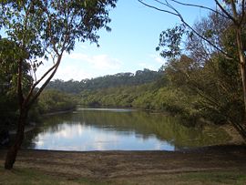
 Twilight Inlet, Bonnet Bay | |||||||||||||||
 | |||||||||||||||
| Population | 2,238 (2021 census)[1] | ||||||||||||||
| Established | 1964[2] | ||||||||||||||
| Postcode(s) | 2226 | ||||||||||||||
| Elevation | 41 m (135 ft) | ||||||||||||||
| Location | 29 km (18 mi) south of Sydney CBD | ||||||||||||||
| LGA(s) | Sutherland Shire | ||||||||||||||
| State electorate(s) | Miranda | ||||||||||||||
| Federal division(s) | Hughes | ||||||||||||||
| |||||||||||||||

Bonnet Bay is a suburb in southern Sydney, in the state of New South Wales, Australia that is located 29 kilometres (18 mi) south of the Sydney central business district in the local government area of the Sutherland Shire. Its postcode is 2226, which it shares with neighbouring Jannali and Como.[3]
Bonnet Bay is located on the eastern bank of the Woronora River, which flows north into the Georges River. Bonnet Bay's boundaries are the Woronora River and Bindea Street in the north, Lincoln Crescent and Taft Place in the east, the suburb of Jannali in the south and the Woronora River in the west. The size of the suburb is approximately 1.5 square kilometres. It contains eight parks which cover almost 24.7% of its total area.[4]
The suburb draws its name from the adjacent bay of the same name.[5] Its terrain consists of Sydney sandstone with steep gullies, creeks, escarpments and one sandstone plateau.[6]
In terms of crime rates, Bonnet Bay has been ranked to be among the top ten safest suburbs in Sydney.[7]
History
[edit]The original name proposed for the area was Kirkby.[8] A rock formation making a cave in the area was known as 'The Bonnet' because it was shaped like an old-fashioned woman's poke bonnet and this was adopted for the name of the bay on the Woronora River which the formation overlooks.[9] The Geographical Names Board decided to name the land area itself Bonnet Bay in 1969. Construction started in late 1969 at Fillmore Rd, with completion of all house plots in 1985.[8]
Demographics
[edit]According to the 2021 Census, there were 2,238 residents in Bonnet Bay, with a median age of 44. In Bonnet Bay, 77.5% of people were born in Australia. The other most common countries of birth were England 5.5%, New Zealand 1.5%, China (excludes SARs and Taiwan) 1.0%, Scotland 0.8% and South Africa 0.8%. 88.3% of people only spoke English at home. Other languages spoken at home included Mandarin 1.5%, Cantonese 1.0%, Greek 1.0%, Spanish 0.8% and Russian 0.7%. The most common responses for religion in Bonnet Bay were No religion, so described 34.7%, Catholic 28.8%, Anglican 16.7%, Eastern Orthodox 3.4% and Uniting Church 2.9%.[1]
Landmarks
[edit]Burnum Burnum Reserve lies between Bonnet Bay, Como, Jannali, Sutherland and Woronora, extending for about two kilometres. The reserve, contiguous with The Glen and Koolangarra reserves,[6] effectively surrounds Bonnet Bay, with main roads cutting through it. Burnum Burnum Reserve hosts some plants that are almost extinct and are protected. However, it also represents a fire threat to Bonnet Bay, most notably manifesting in the 1994 Como bushfires.[10] The reserve was originally known as "Jannali Reserve"[11] but the name was changed in 2005 to commemorate Burnum Burnum, the prominent Aboriginal Sutherland Shire resident. A small plaque in the Reserve details his speech in England on the occasion of Australia's bicentenary in 1988, in which he symbolically claimed England on behalf of Aboriginal people.[12]
A noteworthy feature of this suburb is that all of the streets except one are named after American Presidents.[2] Washington Drive runs through the length of the suburb and is twice split into one-way 'Upper' and 'Lower' sections due to the steep hills it runs across. Nixon, who was the incumbent president when the suburb was established in 1969, is the last president a street is named after. The only street not named after an American president is Tudar Road, which originates in NW Sutherland and cuts through Burnum Burnum reserve to enter Bonnet Bay.
Commercial area, school and transport
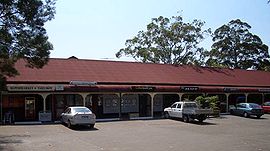
[edit]Bonnet Bay is mostly residential, with a small shopping centre located in Kennedy Crescent, known as the Bonnet Bay Shopping Village. Its shops include a supermarket, hairdresser, pizza restaurant/takeaway and café.[13]
Bonnet Bay Public School is located on Tudar Road.[14] It was officially opened in 1979 by Her Royal Highness Princess Anne, who, in her capacity as president of the Save the Children Fund, had asked to visit a "typical Australian school", with Bonnet Bay Public School being the example chosen.[15] The school also offers before and after school childcare.[16]
Though Bonnet Bay does not have its own train station, neighbouring suburbs Jannali and Como have stations on the Illawarra line of the Sydney Trains network.[17] The Route 968 bus serves Bonnet Bay, connecting it to Jannali, Miranda and Kareela.[18]
Bonnet Bay notably has only two roads for access in and out of the suburb.[19]
Recreation
[edit]Bonnet Bay has a boat ramp,[20] a number of picnic and recreational areas, including a cricket oval, soccer oval, two netball courts, two tennis courts[21] and two baseball fields. Its major recreational area, which is by the water, is Lakewood City Reserve.[22]
Events
[edit]Bonnet Bay was well known in southern Sydney for its extensive displays of Christmas decorations and lights during the festive season,[23] though the tradition reached its peak in the mid-1980s and has since spread to other areas throughout the Sutherland Shire.
Sport
[edit]Bonnet Bay has a single sporting club, Bonnet Bay FC, a football club which fields boys' and girls' junior teams, and men's and women's senior teams, playing at Lakewood City Reserve.[24]
References
[edit]- ^ a b "2021 Bonnet Bay, Census All persons QuickStats | Australian Bureau of Statistics". abs.gov.au. Retrieved 24 February 2023.
- ^ a b "Bonnet Bay". Local History – Sutherland Shire Libraries. Retrieved 8 March 2023.
- ^ "Postcode 2226 - New South Wales (near Sydney) - Postcodes Australia". postcodes-australia.com. Retrieved 23 March 2023.
- ^ "Bonnet Bay". Century 21 Sutherland Shire. Retrieved 12 November 2024.
- ^ "Bonnet Bay (NSW)". Gazetteer of Australia online. Geoscience Australia, Australian Government.
- ^ a b Harrington, Michael. "A forty year history of bushcare at Bonnet bay, NSW". Australasian Plant Conservation: Journal of the Australian Network for Plant Conservation. pp. 12–13. Retrieved 8 March 2023.
- ^ "10 Safest Suburbs in Sydney for 2020". Sydney Suburb Reviews. 11 August 2020. Retrieved 9 March 2023.
- ^ a b History of Sutherland Shire Placenames Archived 19 July 2008 at the Wayback Machine
- ^ "The Bonnet". Local History - Sutherland Shire Libraries. Retrieved 19 March 2023.
- ^ "Bush Fire Disaster, 1994". Local History – Sutherland Shire Libraries. Retrieved 8 March 2023.
- ^ "Burnum Burnum Reserve – Sydney". wikimapia.org. Retrieved 8 March 2023.
- ^ "5 July 2020 // Burnum Burnum | #ABHM2020". Abhm2020. Retrieved 8 March 2023.
- ^ Gainsford, Jim (25 October 2018). "Bonnet Bay Shopping Centre sells for $3.7 million at auction". St George & Sutherland Shire Leader. Retrieved 24 February 2023.
- ^ "Home – Bonnet Bay Public School". bonnetbay-p.schools.nsw.gov.au. Retrieved 24 February 2023.
- ^ "History – Bonnet Bay Public School". bonnetbay-p.schools.nsw.gov.au. Retrieved 8 March 2023.
- ^ "Enquire Bonnet Bay Before and After School Care | KindiCare". Enquire Bonnet Bay Before and After School Care | KindiCare. Retrieved 19 March 2023.
- ^ "Sydney Train Map". railmaps.com.au. Retrieved 8 March 2023.
- ^ "Route 968 bus timetable" (PDF). Retrieved 8 March 2023.
- ^ Trembath, Murray (3 February 2020). "Bonnet Bay 'escape routes' review". St George & Sutherland Shire Leader. Retrieved 8 March 2023.
- ^ Council, Sutherland Shire (30 August 2022). "Bonnet Bay Boat Ramp". sutherlandshire.nsw.gov.au. Retrieved 8 March 2023.
- ^ "Bonnet Bay Tennis Courts". Bonnet Bay Tennis Courts. Retrieved 8 March 2023.
- ^ Council, Sutherland Shire (24 October 2022). "Lakewood City Reserve, Bonnet Bay". sutherlandshire.nsw.gov.au. Retrieved 8 March 2023.
- ^ Benns, Matthew (3 December 2006). "Light relief – even Scrooge wouldn't worry about the cost". The Sydney Morning Herald. Retrieved 8 March 2023.
- ^ "Home of the Bombers!". Bonnet Bay Football Club. Retrieved 7 March 2023.
