Blackdown Rings
Appearance
![](http://up.wiki.x.io/wikipedia/commons/thumb/b/b3/Blackdown_Rings_-_South_Devon_-_geograph.org.uk_-_31038.jpg/220px-Blackdown_Rings_-_South_Devon_-_geograph.org.uk_-_31038.jpg)
![](http://up.wiki.x.io/wikipedia/commons/thumb/9/9d/Blackdown_Rings_-_South_Devon_-_geograph.org.uk_-_31036.jpg/220px-Blackdown_Rings_-_South_Devon_-_geograph.org.uk_-_31036.jpg)
![](http://up.wiki.x.io/wikipedia/commons/thumb/9/99/Blackdown_Rings_Digital_Terrain_Model.jpg/220px-Blackdown_Rings_Digital_Terrain_Model.jpg)
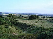
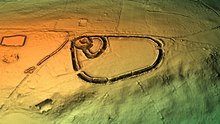
The Blackdown Rings are the earthworks of an Iron Age hill fort near the hamlet of Hazelwood in Devon, England. The fort is situated on a hilltop approximately 185 metres (607 ft) above sea level, in a commanding position above the River Avon.[1]
References
[edit]- ^ Sellman, R. R. (1985). Aspects of Devon History. Exeter: Devon Books. p. 11. ISBN 0-86114-756-1.
Wikimedia Commons has media related to Blackdown Rings.
50°21′15″N 3°48′01″W / 50.3543°N 3.8003°W