Bishwanath Upazila
This article needs additional citations for verification. (December 2012) |
Bishwanath
বিশ্বনাথ | |
|---|---|
 | |
| Country | |
| Division | Sylhet |
| District | Sylhet |
| Area | |
• Total | 213.16 km2 (82.30 sq mi) |
| Population | |
• Total | 237,213 |
| • Density | 1,100/km2 (2,900/sq mi) |
| Demonym(s) | Bishwanathi, Bishnathi |
| Time zone | UTC+6 (BST) |
| Postal code | 3130[2] |
| Area code | 08224[3] |
| Website | bishwanath |
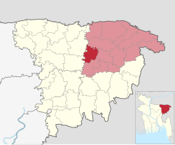
Bishwanath (Bengali: বিশ্বনাথ) is an upazila of Sylhet District in the Division of Sylhet, Bangladesh.[4]
History
[edit]One of the palaces of Gour Govinda, the last Hindu ruler of Sylhet, was situated in present-day Bishwanath. Its ruins are still intact and is locally referred to as 'Jahazer Manzil' and next to Govinda's personal pond, the 'Satpari Dighi'.[4] During the Muslim conquest of Sylhet in 1303, Govinda abandoned Sylhet and fled to the Kamrup region. Shah Jalal, a leader of the conquest, was known to have dispatched his disciples across the region to propagate Islamic teachings. Among the disciples that arrived in present-day Bishwanath is Syed Batauk, the ancestor of Abdul Karim Kauria.[5] Shah Chand was the son of Shaykh Kalu, another of Shah Jalal's disciples,[6] and the village of Chandbharang was named after him. Shah Chand is the forefather of the Chowdhuries of Chandbharang, including Suheluddin Chowdhury and Shafiqur Rahman Chowdhury.[7]
After the defeat of Raja Subid Narayan of Ita by Khwaja Usman in the early 17th century, many Hindus migrated elsewhere including the area now comprising Bishwanath. Vijayaram Upadhayaya and his Kayastha student Bidhar Khan sailed with their family and friends through the Kapna river to this area (then a forest) for safety. The area was then home to a group of bandits led by Jula, but they were defeated by Bidhar Khan and his associates. The new settlers named the area 'Banabhag' (forest area), the area which he docked his boat came to be known as 'Bidhar Ghat' and the neighbourhood of the bandits came to be known as 'Jular Chiri'. When the Mughals came into power, they divided Banabhag into three parganas: Khalisa-Banabhag, Bazu-Banabhag and Kazakhabad. Bidhar Khan became the Zamindar of Bazu-Banabhag. His descendant, Ramnath Dhar, was a contemporary of Gopinath Bachaspati. Dhar's son, Babu Ramjivan Rai, was given the title of Chowdhury and granted land in Baurbhag by Inayetullah Khan, the Mughal administrator of Sylhet, in 1692. He was known to have been devoted to idol worship.[8] His son, Bhavani Shankar, was the father of Zamindar Ram Shankar Chowdhury. Ram Shankar's son, Bishwanath Rai Chaudhury, established the 'Bishwanath Bazaar' which gradually expanded. His son, Brajanath Chaudhury, established an akhara for Chaitanya Mahaprabhu and was succeeded by Baikuntha Nath Chaudhury. Baikuntha Nath's son, Varada Nath Chaudhury, was a distinguished poet of Bishwanath.[9]
Bishwanath was established as a thana in 1922. During the Bangladesh Liberation War of 1971, many Hindus were killed in Bishwanath including Jitendra Das, Dhirendra Kumar Das, Byomkesh Chaudhury, Narayan Sen and Basanta Kumar Das. Bishwanath Thana was upgraded to upazila (sub-district) in 1983 as part of the President of Bangladesh Hussain Muhammad Ershad's decentralisation programme.[4]
Demographics
[edit]According to the 2011 Census of Bangladesh, Bishwanath Upazila had 37,993 households and a population of 232,573. 59,991 (25.79%) were under 10 years of age. Bishwanath had a literacy rate (age 7 and over) of 46.87%, compared to the national average of 51.8%, and a sex ratio of 1009 females per 1000 males. 21,059 (9.05%) lived in urban areas.[11][12]
At the 1991 Bangladesh census, Bishwanath had a population of 169,730, of whom 83,794 were aged 18 or older. Males constituted 50.99% of the population, and females 49.01%. Bishwanath had an average literacy rate of 30.6% (7+ years), against the national average of 32.4%.[13]
Education
[edit]The first alia madrasa of Bishwanath, Satpur Alia Madrasa in Lamakazi Union, was founded in 1948 by Ghulam Hussain, a native wali of Satpur and murid of Pir Hamidullah Qaimganji and Abdul Latif Chowdhury Fultali. In 1960, the Bishwanath Alia Madrasa was established.[4] The largest Qawmi madrasa of Bishwanath, Jamia Islamia Abbasia, was opened by Abdul Karim Shaykh-e-Kauria in 1955. There are 28 other madrasas in Bishwanath. They are: Jamia Islamia Darul Uloom Madania (founder, Ashraf Ali Bishwanathi), Jamia Islamia Miftahul Uloom (Ibrahit Ali, 1963), Munawwarul Uloom Islamia Madrasa (1992), Jamia Islamia Darul Uloom Lamakazi, Darul Quran Faiz-e-Aam Mirerchak, Jamia Islamia Darus Sunnah Amtail, Darul Uloom Chandbharang, Jamia Islamia Lutfabad-Patakain, Jamia Islam Darul Uloom Baruni, Madrasa-e-Tawakkulia Hafizia Sham-e-Mardan, Sheikhergaon Ibn Abbas Ibtidayi Madrasa, Haji Md Mafiz Ali Tahfizul Quran and Ibtidayi Madrasa, Darul Hikmah Islamic Academy, Jamia Madinatul Uloom Shimultala, Muqaddasia Islamia Hafizia Madrasa, Madinatul Uloom Sriramsri, Ariful Quran Hafizia Madrasa, Great Khurma Islamic Academy, Jamia Muhammadia Arabia, Jamia Tawakkulia Chowk Qasimpur, Jamia Islamia Hafizia Rampasha, Jamia Islamia Noagaon, Madinatul Uloom Nurani Hafizia Madrasa, Jamia Islamia Markazul Uloom Qadipur (Haji Shafiq Ali, 2016).[5] Bishwanath also has three women's madrasas: Jamia Madania Qawmia Women's Madrasa, Jamia Tayyibah Qawmi Women's Madrasa (Anhar bin Saeed, 2018), Dhu al-Nuraryn Islamia Women's Madrasa (Amirul Islam, 2008).
Administration
[edit]Bishwanath Upazila is divided into eight union parishads: Alankari, Bishwanath, Doshghar, Daulatpur, Deokalas, Khajanchi, Lamakazi, and Rampasha. The union parishads are subdivided into 123 mauzas and 444 villages.[11]
Notable people
[edit]- Jatindramohan Bhattacharya, academic and literary researcher
- Ashraf Ali Bishwanathi, Islamic scholar
- Nurul Islam Khan, Advocate and former MP for Sylhet-7
- Ilias Ali, former MP for Sylhet-2
- Mokabbir Khan, former MP for Sylhet-2
- Muhammad Nurul Haque, cultural activist, social worker and writer
- Ragib Ali, industrialist, tea-planter, educationalist
- Rubel Ahmed, died in Morton Hall Immigration Removal Centre under controversial circumstances
- Rushanara Ali, British politician
- Shafiqur Rahaman Chowdhury, Awami League politician
- Hason Raja, mystic poet, musician, philosopher
See also
[edit]References
[edit]- ^ National Report (PDF). Population and Housing Census 2022. Vol. 1. Dhaka: Bangladesh Bureau of Statistics. November 2023. p. 404. ISBN 978-9844752016.
- ^ "Bangladesh Postal Code". Dhaka: Bangladesh Postal Department under the Department of Posts and Telecommunications of the Ministry of Posts, Telecommunications and Information Technology of the People's Republic of Bangladesh. 20 October 2024.
- ^ "Bangladesh Area Code". Stockholm, Sweden: Rebtel.com. 18 October 2024.
- ^ a b c d Jayanta Singh Roy (2012). "Bishwanath Upazila". In Sirajul Islam; Miah, Sajahan; Khanam, Mahfuza; Ahmed, Sabbir (eds.). Banglapedia: the National Encyclopedia of Bangladesh (Online ed.). Dhaka, Bangladesh: Banglapedia Trust, Asiatic Society of Bangladesh. ISBN 984-32-0576-6. OCLC 52727562. OL 30677644M. Retrieved 25 December 2024.
- ^ a b Ahmed, Masum (7 November 2018). আল্লামা আব্দুল করিম কৌড়িয়া রহঃ এর সংগ্রামী জীবন (in Bengali).
- ^ Qurashi, Ishfaq. "তিন'শ ষাট আউলিয়ার বিবরণ" [Description of the three hundred and sixty saints]. শাহজালাল(রঃ) এবং শাহদাউদ কুরায়শী(রঃ) [Shahjalal and Shah Dawud Qurayshi (R)] (in Bengali).
- ^ Ali, Syed Murtaza (1965). হজরত শাহ জালাল ও সিলেটের ইতিহাস [Hazrat Shah Jalal and the History of Sylhet] (in Bengali). Dhaka: University Press. p. 34.
- ^ Choudhury, Achyut Charan (2000) [1916]. "কায়স্থাদির কথা: বনভাগের চৌধুরী". Srihatter Itibritta: Uttorangsho (in Bengali). Kolkata: Kotha. pp. 101–102.
- ^ বিশ্বনাথ উপজেলার পটভূমি [Background of Viswanath Upazila]. Bishwanath Upazila.
- ^ Population and Housing Census 2022 - District Report: Sylhet (PDF). District Series. Dhaka: Bangladesh Bureau of Statistics. June 2024. ISBN 978-984-475-269-6.
- ^ a b "Bangladesh Population and Housing Census 2011 Zila Report – Sylhet" (PDF). bbs.gov.bd. Bangladesh Bureau of Statistics.
- ^ "Community Tables: Sylhet district" (PDF). bbs.gov.bd. Bangladesh Bureau of Statistics. 2011.
- ^ "Population Census Wing, BBS". Archived from the original on 2005-03-27. Retrieved November 10, 2006.

