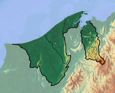
Benutan Dam
Appearance
| Benutan Dam | |
|---|---|
| Country | Brunei |
| Location | Tutong District |
| Coordinates | 4°37′45.32″N 114°45′02.69″E / 4.6292556°N 114.7507472°E |
| Purpose | Water supply |
| Status | Operational |
| Opening date | 1988 |
| Dam and spillways | |
| Type of dam | Embankment |
| Impounds | Benutan River |
| Height | 22 m (72 ft) |
| Reservoir | |
| Total capacity | 45,000,000 m3 (36,000 acre⋅ft) |
| Catchment area | 28.5 m (94 ft) |
The Benutan Dam, also spelled Binutan, is an embankment dam on the Benutan River in Tutong District, Brunei. The dam was completed in 1988 with the primary purpose of increasing water supply to the capital of Brunei, Bandar Seri Begawan. It has a normal reservoir volume of 45,000,000 m3 (36,000 acre⋅ft).[1][2][3]
See also
[edit]References
[edit]- ^ Kajander, Tommi (June 2001). "Global Changes and Water Resources" (PDF). Helsinki University of Technology. p. 30. Archived from the original (PDF) on 15 April 2014. Retrieved 14 April 2014.
- ^ "Dams & hydro plants.(Directory)(Illustration)". International Water Power & Dam Construction. 1 May 2004. Archived from the original on 15 April 2014. Retrieved 14 April 2014.
- ^ Britannica Book of the Year: 1990, Volume 33. Encyclopædia Britannica. 1990. p. 207. ISBN 0852295227.

