Belgrave, Cheshire

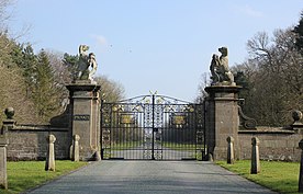
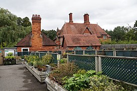
Belgrave is a historic village in Cheshire, England. The area is part of the estates owned the Dukes of Westminster who have their seat at Eaton Hall, Cheshire.[1] The village has a few houses and the Grosvenor Garden Centre.[2] Belgrave Lodge is located at the western end of the 1.7 mi (2.7 km) main approach to Eaton Hall, which is known as the Belgrave Avenue.[3] The name Belgrave is based on the Anglo-Saxon meaning for “beautiful grove”, which Normans replaced after the Conquest from the old name “Medregrave” which in Old French meant “filth grove”.[4]

The village is also one of the Duke of Westminster's subsidiary titles, Viscount Belgrave (1784) which is the source of the name of Belgravia in London,[5] which was developed in the 1820s by Thomas Cubitt on land originally owned by Richard Grosvenor, 2nd Marquess of Westminster.[6] Belgravia, which is one of the capital's most expensive districts, is characterised by grand terraces of white stucco properties.[7] Many of the street names of Belgravia have a local connection to Cheshire such as Eaton Square (Eaton Hall), Chester Square (Chester), Kinnerton Street (Lower Kinnerton), and Eccleston Place (Eccleston).[8][9]
References
[edit]- ^ "Mayfair and Belgravia Public Realm Handbook". www.grosvenorlondon.com. Retrieved 18 March 2021.
- ^ "Garden Centre". bluediamond.gg. Retrieved 18 March 2021.
- ^ Historic England, "Belgrave Lodge and storesheds and domestic offices (1129922)", National Heritage List for England, retrieved 1 June 2013
- ^ https://www.houseofnames.com/belgrave-family-crest
- ^ "The western suburbs: Belgravia". www.british-history.ac.uk. Retrieved 18 March 2021.
- ^ "THE GROSVENOR ESTATE: CHESTER SQUARE". www.historicengland.org.uk. Retrieved 18 March 2021.
- ^ "The Architecture of the Estate: The Reign of the Cundys". www.historicengland.org.uk. Retrieved 18 March 2021.
- ^ Fairfield, Sheila (1972). The Streets Of London: A Dictionary Of The Names And Their Origins. BT Batsfrd Ltd.
- ^ *Bebbington, Gillian (1983). London Street Names. Papermac. ISBN 978-0-333-28649-4.
53°08′36″N 2°55′12″W / 53.14332°N 2.91996°W
