Bedrock, Colorado
Bedrock, Colorado | |
|---|---|
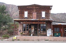
 Bedrock's general store | |
| Coordinates: 38°18′54″N 108°53′27″W / 38.31500°N 108.89083°W | |
| Country | United States |
| State | Colorado |
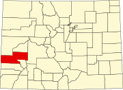
| County | Montrose County |
| Established | 1883[1] |
| Elevation | 4,990 ft (1,520 m) |
| Time zone | UTC-7 (MST) |
| • Summer (DST) | UTC-6 (MDT) |
| ZIP Code | 81411[3] |
| GNIS feature ID | 185822[2] |
Bedrock is an unincorporated community and U.S. post office in western Montrose County, Colorado, United States. The ZIP code of Bedrock is 81411.[3]
History
[edit]The town of Bedrock was established in 1883.[1] The Bedrock post office opened on November 8, 1883.[4] The town's general store and post office were built on solid rock, hence the name.[1] The general store originally served the ranching community of Paradox Valley and later also served uranium miners in the 20th century.[5]
The general store was built in 1882 and featured in the 1991 film Thelma & Louise.
Geography
[edit]Bedrock is located in the southwest margin of Paradox Valley. The Dolores River enters the Paradox Valley approximately one quarter of a mile southeast of the community. Naturita lies 20 miles to the east along Colorado State Highway 90.[6]
References
[edit]- ^ a b c Eichler, Geo. R. (1977). Colorado Place Names. Boulder, Colo.: Johnson Publishing Company. LCCN 77-89726.
- ^ a b U.S. Geological Survey Geographic Names Information System: Bedrock, Colorado
- ^ a b "ZIP Code Lookup". United States Postal Service. Archived from the original (JavaScript/HTML) on September 3, 2007. Retrieved September 3, 2007.
- ^ Bauer, William H.; James L. Ozment; John H. Willard (1990). Colorado Post Offices 1859-1989. Denver, Co.: The Colorado Railroad Museum. ISBN 0-918654-42-4. LCCN 90-034759.
- ^ "Bedrock Store".
- ^ Paradox, CO, 7.5 Minute Topographic Quadrangle, USGS, 1994


