Bec d'Ambès
Appearance

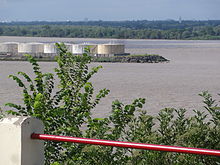
The Bec d'Ambès (French pronunciation: [bɛk dɑ̃bɛs], literally Beak of Ambès) is the point of confluence of the rivers Garonne and Dordogne, in the Gironde estuary.[1] Situated 15 miles north of Bordeaux, it has an oil refinery which was destroyed by bombing during World War II, but rebuilt after the war.[2] It is in the Ambès commune.
References
[edit]- ^ Chanson, Hubert (2011). Tidal Bores, Aegir, Eagre, Mascaret, Pororoca: Theory and Observations. World Scientific. p. 48. ISBN 978-9814335423. Retrieved 23 December 2014.
- ^ "Bec d'Ambès". Petroleum Refiner. 34: 102. 1955. Retrieved 23 December 2014.
