Barwon Downs
Appearance
| Barwon Downs Victoria | |||||||||||||||
|---|---|---|---|---|---|---|---|---|---|---|---|---|---|---|---|
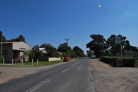
 The main street of Barwon Downs with the public hall on the left and the general store on the right (now closed) | |||||||||||||||
| Coordinates | 38°28′0″S 143°45′0″E / 38.46667°S 143.75000°E | ||||||||||||||
| Population | 131 (2016 census)[1] | ||||||||||||||
| Postcode(s) | 3243 | ||||||||||||||
| Location | |||||||||||||||
| LGA(s) | Colac Otway Shire | ||||||||||||||
| State electorate(s) | Polwarth | ||||||||||||||
| Federal division(s) | Corangamite | ||||||||||||||
| |||||||||||||||
Barwon Downs is a town in Victoria, Australia. The town is located in the foothills of the Otway Ranges, 151 kilometres (94 mi) south west of the state capital, Melbourne. The township was proclaimed on 10 May 1910.[2] In the 2016 census, Barwon Downs had a population of 131.[1]
The main industries in the area are agriculture, forestry and tourism. The town has a church, tennis courts and public hall. Barwon Downs also has a local Country Fire Authority (CFA) with members from the local community. Since the 1990s an aquifer in the Barwon Downs area have been used as a supply of water for Geelong in periods of drought.[3]
References
[edit]- ^ a b Australian Bureau of Statistics (27 June 2017). "Barwon Downs (State Suburb)". 2016 Census QuickStats. Retrieved 17 November 2017.
- ^ Brien, Gavin (17 May 2010). "Barwon Downs ULT official handover". Archived from the original on 5 April 2011. Retrieved 5 April 2011. (*dead link)
- ^ Bowlen, Kathy (10 October 2008). "Transcript Barwon Bore: Has the answer to Geelong's water crisis come at a cost to the environment?". Stateline Victoria. ABC. Archived from the original on 12 November 2012. Retrieved 5 April 2011.
External links
[edit]![]() Media related to Barwon Downs at Wikimedia Commons
Media related to Barwon Downs at Wikimedia Commons


