Bělotín
Bělotín | |
|---|---|
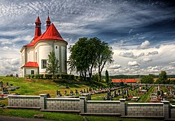
 Church of Saint George | |
| Coordinates: 49°35′28″N 17°48′24″E / 49.59111°N 17.80667°E | |
| Country | |
| Region | Olomouc |
| District | Přerov |
| First mentioned | 1201 |
| Area | |
• Total | 33.39 km2 (12.89 sq mi) |
| Elevation | 297 m (974 ft) |
| Population (2024-01-01)[1] | |
• Total | 1,857 |
| • Density | 56/km2 (140/sq mi) |
| Time zone | UTC+1 (CET) |
| • Summer (DST) | UTC+2 (CEST) |
| Postal code | 753 64 |
| Website | www |
Bělotín (German: Bölten) is a municipality and village in Přerov District in the Olomouc Region of the Czech Republic. It has about 1,900 inhabitants.
Administrative parts
[edit]The villages of Kunčice, Lučice and Nejdek are administrative parts of Bělotín.
Geography
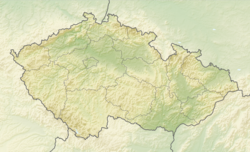
[edit]Bělotín is located about 29 kilometres (18 mi) northeast of Přerov and 38 km (24 mi) east of Olomouc. It lies mostly in the Moravian Gate valley. The northern part of the municipal territory lies in the Nízký Jeseník range and includes the highest point of Bělotín at 481 m (1,578 ft) above sea level. In the south, the municipality also briefly extends into the Moravian-Silesian Foothills.
The Luha River flows across the municipality. The village of Bělotín is mostly located around the stream Bělotínský potok, which flows to the Luha. There are two notable fishponds in the municipality: Horní Bělotín and Dolní Bělotín.
History
[edit]The first written mention of Bělotín is from 1201. The village was founded in the second half of the 12th century. Until the German colonization in the 14th century, the population was purely Slavic.[2]
Until the turn of the 14th and 15th centuries, Bělotín was owned by the Hradisko Monastery as a part of the Hranice estate. In 1475, the estate was acquired by the Pernštejn family, then it was sold to the Haugvic of Biskupice family in 1548. After it changed its owners several times, the estate was confiscated after the Battle of White Mountain and donated to Franz von Dietrichstein. His house held Bělotín and the whole Hranice estate until 1858.[2]
During World War II, Bělotín was annexed by Nazi Germany and administered as part of the Reichsgau Sudetenland. The municipality was the base for a detached Work Camp E540 (Arbeitskommando E540) for British and Commonwealth prisoners of war, under the administration of the Stalag VIII-B/344 prisoner-of-war camp at Łambinowice.[3] In January 1945, as the Soviet armies resumed their offensive and advanced from the east, the prisoners of the whole Stalag VIII-B/344 POW camp were marched westward in the Long March.
Demographics
[edit]
|
|
| ||||||||||||||||||||||||||||||||||||||||||||||||||||||
| Source: Censuses[4][5] | ||||||||||||||||||||||||||||||||||||||||||||||||||||||||
Transport
[edit]The D1 motorway and its branch, the D48 motorway, run through the municipality.
Bělotín is located on the railway line Ostrava–Hranice.[6]
Sights
[edit]The main landmark of Bělotín is the Church of Saint George. It was built in the Baroque style in 1754, but it has a Renaissance tower. The second cultural monument in the municipality is the cemetery Church of Saint Urban in Nejdek, dating from 1752.[7]
Twin towns – sister cities
[edit] Hinterschmiding, Germany
 Höchst im Odenwald, Germany
 Kolonowskie, Poland
References
[edit]- ^ "Population of Municipalities – 1 January 2024". Czech Statistical Office. 2024-05-17.
- ^ a b "Historie Bělotína" (in Czech). Obec Bělotín. Retrieved 2022-02-07.
- ^ "Working Parties". lamsdorf.com. Archived from the original on 2020-10-29. Retrieved 2021-11-12.
- ^ "Historický lexikon obcí České republiky 1869–2011" (in Czech). Czech Statistical Office. 2015-12-21.
- ^ "Population Census 2021: Population by sex". Public Database. Czech Statistical Office. 2021-03-27.
- ^ "Detail stanice Bělotín" (in Czech). České dráhy. Retrieved 2024-05-02.
- ^ "Památky a významné stavby" (in Czech). Obec Bělotín. Retrieved 2022-02-07.
- ^ "Main Page: Partneři" (in Czech). Obec Bělotín. Retrieved 2022-02-07.


