Arahal
Arahal | |
|---|---|
 | |
| Coordinates: 37°15′N 5°32′W / 37.250°N 5.533°W | |
| Country | |
| Autonomous community | |
| Province | Seville |
| Comarca | La Campiña |
| Government | |
| • Mayor | Miguel Ángel Márquez González |
| Area | |
• Total | 201.09 km2 (77.64 sq mi) |
| Elevation | 117 m (384 ft) |
| Population (2018)[1] | |
• Total | 19,565 |
| • Density | 97/km2 (250/sq mi) |
| Demonym | Arahalenses[2] |
| Time zone | UTC+1 (CET) |
| • Summer (DST) | UTC+2 (CEST) |
| Postal code | 41600 |
| Website | Official website |
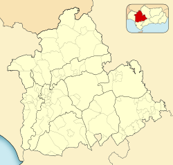
Arahal is a municipality in Seville, Andalusia, Spain. It is situated on the southeast of Seville. This town is also known as "El Arahal", with this name recognized until 1981.[3] Ar-rahal is an Arabic term which means a place in the path where stopping to rest.
Monuments
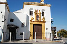
[edit]The municipality features several monuments in Arahal, most of them churches, including:
- Nta.Sra. de la Victoria church. Temple finished in 1551 and the tower late XVII
- Vera-Cruz church. 1602
- Casa Peralta. 1895

- Nta.Sra. del Rosario convent. 1608
- San Roque church (ex-convent). 1624
- Santo Cristo de la Misericordia church. 16th century
- Santa María Magdalena parish-church. It comes in a Neoclassical style and is one of the biggest in the province. It was rebuilt in 1800 after the 1755 Lisbon earthquake destroyed the old one, the tower remains from the previous temple. Mary Magdalene is the patron saint of the town.
- San Antonio hermitage built in the 17th century.
Climate
[edit]Arahal has a Mediterranean climate Csa according to the Köppen climate classification, it is characterized by its variable rainfall, dry summers and extremely hot summers and mild winters and often rainy. One of the official historical higher temperatures was record in Arahal when the thermometer reached 49 °C on the shade on July 23, 1995, according to the Statistical Yearbook of Andalusia, the INM and AEMET. Arahal has a weather station located at Moron Air Base, whose station data represents the climate of Arahal, in operation since 1951.
| Climate data for Arahal (Air base) | |||||||||||||
|---|---|---|---|---|---|---|---|---|---|---|---|---|---|
| Month | Jan | Feb | Mar | Apr | May | Jun | Jul | Aug | Sep | Oct | Nov | Dec | Year |
| Record high °C (°F) | 27.6 (81.7) |
28.6 (83.5) |
30.6 (87.1) |
34.7 (94.5) |
39.7 (103.5) |
44.8 (112.6) |
46.6 (115.9) |
46.0 (114.8) |
43.2 (109.8) |
35.6 (96.1) |
30.0 (86.0) |
28.0 (82.4) |
46.6 (115.9) |
| Mean daily maximum °C (°F) | 15.7 (60.3) |
17.4 (63.3) |
20.8 (69.4) |
22.2 (72.0) |
26.0 (78.8) |
31.2 (88.2) |
35.2 (95.4) |
34.7 (94.5) |
31.0 (87.8) |
25.4 (77.7) |
19.7 (67.5) |
16.4 (61.5) |
24.7 (76.5) |
| Daily mean °C (°F) | 9.9 (49.8) |
11.3 (52.3) |
13.9 (57.0) |
15.5 (59.9) |
18.9 (66.0) |
23.3 (73.9) |
26.7 (80.1) |
26.9 (80.4) |
23.9 (75.0) |
19.2 (66.6) |
14.1 (57.4) |
11.3 (52.3) |
17.9 (64.2) |
| Mean daily minimum °C (°F) | 4.1 (39.4) |
5.2 (41.4) |
7.0 (44.6) |
8.8 (47.8) |
11.7 (53.1) |
15.5 (59.9) |
18.2 (64.8) |
19.0 (66.2) |
16.7 (62.1) |
13.0 (55.4) |
8.5 (47.3) |
6.1 (43.0) |
11.2 (52.2) |
| Record low °C (°F) | −8.0 (17.6) |
−7.8 (18.0) |
−4.2 (24.4) |
−0.4 (31.3) |
1.6 (34.9) |
6.0 (42.8) |
3.0 (37.4) |
9.0 (48.2) |
5.4 (41.7) |
1.2 (34.2) |
−2.4 (27.7) |
−7.0 (19.4) |
−8.0 (17.6) |
| Average precipitation mm (inches) | 68 (2.7) |
53 (2.1) |
42 (1.7) |
60 (2.4) |
39 (1.5) |
9 (0.4) |
2 (0.1) |
4 (0.2) |
27 (1.1) |
67 (2.6) |
86 (3.4) |
94 (3.7) |
543 (21.4) |
| Average precipitation days | 6 | 6 | 5 | 7 | 4 | 1 | 0 | 0 | 2 | 6 | 7 | 8 | 53 |
| Average relative humidity (%) | 74 | 71 | 64 | 61 | 57 | 50 | 44 | 47 | 54 | 64 | 72 | 77 | 61 |
| Mean monthly sunshine hours | 182 | 186 | 221 | 236 | 287 | 331 | 360 | 337 | 243 | 220 | 182 | 163 | 2,948 |
| Source: [4] | |||||||||||||
Transport
[edit]Arahal has a train station, with connections to Sevilla, Dos Hermanas, Marchena, and Malaga by Renfe railways. There are also bus connections to Malaga Airport.
37°16′N 5°33′W / 37.267°N 5.550°W
References
[edit]- ^ Municipal Register of Spain 2018. National Statistics Institute.
- ^ Pancracio, Celdrán Gomáriz (2004). Diccionario de topónimos españoles y sus gentilicios (5th ed.). Madrid: Espasa Calpe. p. 75. ISBN 978-84-670-3054-9.
- ^ Instituto Nacional de Estadística de España (15 December 2009). "Alteraciones de los municipios en los Censos de Población desde 1842".
- ^ "Valores climatológicos normales. Arahal, weather station located in Moron de la frontera Air base". Aemet.es. Retrieved 14 August 2016.


