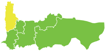
Al-Suqaylabiyah District
Appearance
35°22′11″N 36°22′48″E / 35.369722°N 36.38°E

Al-Suqaylabiyah District (Arabic: السقيلبية As Suqailabiya) is a district (mantiqah) administratively belonging to Hama Governorate, Syria. At the 2004 official census, the district had a population of 240,091.[1] Its administrative centre is the city of al-Suqaylabiyah. The district includes most of al-Ghab plain. It is currently controlled by the Syrian transitional government.
Sub-districts
[edit]The district of Hama is divided into five sub-districts or nahiyahs (population according to 2004 official census):
- Al-Suqaylabiyah Subdistrict (ناحية السقيلبية): population 49,686.[2]
- Tell Salhab Subdistrict (ناحية تلسلحب): population 38,783.[3]
- Al-Ziyarah Subdistrict (ناحية الزيارة): population 38,872.[4]
- Shathah Subdistrict (ناحية شطحة): population 25,273.[5]
- Qalaat al-Madiq Subdistrict (ناحية قلعة المضيق): population 85,597.[6]
References
[edit]- ^ 2004 official census Archived 2013-03-10 at the Wayback Machine
- ^ "Al-Suqaylabiyah nahiyah population". Cbssyr.org. Archived from the original on 2013-01-13. Retrieved 2012-06-19.
- ^ "Talsalhab nahiyah population". Cbssyr.org. Archived from the original on 2013-01-13. Retrieved 2012-06-19.
- ^ "Az-Ziyarah nahiyah population". Cbssyr.org. Archived from the original on 2012-12-20. Retrieved 2012-06-19.
- ^ "Shattha nahiyah population". Cbssyr.org. Archived from the original on 2013-01-12. Retrieved 2012-06-19.
- ^ "Qal'at al-Madiq nahiyah population". Cbssyr.org. Retrieved 2012-06-19.[permanent dead link]
