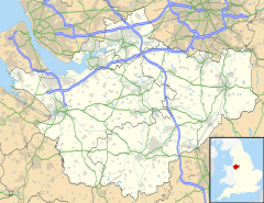
Agden, Cheshire East
Appearance
| Agden | |
|---|---|
 Agden Hall | |
Location within Cheshire | |
| Population | 146 [1] |
| OS grid reference | SJ725859 |
| Civil parish | |
| Unitary authority | |
| Ceremonial county | |
| Region | |
| Country | England |
| Sovereign state | United Kingdom |
| Post town | ALTRINCHAM |
| Postcode district | WA14 |
| Dialling code | 01925 |
| Police | Cheshire |
| Fire | Cheshire |
| Ambulance | North West |
| UK Parliament | |
Agden is a former civil parish, now in the parish of Little Bollington with Agden,[2] in the borough of Cheshire East and the ceremonial county of Cheshire, England. It is near High Legh, and about 15 miles (24 km) south-west from Manchester City Centre. It is the site of Agden Hall. According to the 2001 census, the population of the civil parish was 146.[1] Because the population is so small, it did not have a parish council, instead, relying on a parish meeting.[3]
History
[edit]Agden was formerly a township in the parishes of Bowden and Rostherne,[4] in 1866 Agden became a civil parish,[5] on 1 April 2023 the parish was abolished to form "Little Bollington with Agden".[6]
References
[edit]Wikimedia Commons has media related to Agden, Cheshire East.
- ^ a b 2001 Census Details. Accessed 15-May-2007.
- ^ "Little Bollington with Agden". Mapit. Retrieved 6 July 2023.
- ^ Macclesfield Borough Website, Parish Clerks sub-page. Archived 11 April 2008 at the Wayback Machine Accessed 15-May-2007.
- ^ "History of Agden, in Macclesfield and Cheshire". A Vision of Britain through Time. Retrieved 6 July 2023.
- ^ "Relationships and changes Agden CP/Tn through time". A Vision of Britain through Time. Retrieved 6 July 2023.
- ^ "Cheshire East Registration District". UKBMD. Retrieved 9 October 2023.

