Aden Governorate
Aden
محافظة عدن | |
|---|---|
 | |
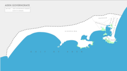
 Districts map of Aden | |
| Country | |
| Region | Aden Region |
| Seat | Aden |
| Government | |
| • Governor | Ahmed Lamlas |
| Area | |
• Total | 1,114 km2 (430 sq mi) |
| Population (2011)[1] | |
• Total | 1,917,000 |
| • Density | 1,700/km2 (4,500/sq mi) |
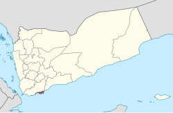
Aden (Arabic: عَدَنْ ) is a governorate of Yemen, including the city of Aden. At the 2004 census, it had a population of 589,419.[2] The ancient capital, the port city of Crater, was located here.
Aden was under British rule in the period from 1839 to 1967. In 1967, after years of struggle, Aden and other southern their independence. The city of Aden became the capital of South Yemen between 1967 and 1990. In 1990, both South Yemen and North Yemen combined to form the present Republic of Yemen. Aden is now the commercial capital of the Republic of Yemen.[citation needed]
The archipelago of Socotra was part of the Governorate of Aden, but it was attached to Hadhramaut Governorate in 2004.[citation needed]
On 6 December 2015, the governor of Aden, General Jaafar Mohammed Saad, was killed a car bomb attack that also killed six members of his entourage. Several other were wounded. after the attack, the Islamic State responsibility.[3] On July 29, 2020, Ahmed Hamed , the STC secretary general was by the Yemeni president as new governor of Aden as a result of the modified version of the Riyadh agreement signed between the Yemeni government and the southern transitional council representatives.
Geography
[edit]At 1,114 square kilometers, Aden is the second-smallest governorate in Yemen by area. However, its population density is the second-highest, after Sanaa Governorate.
Adjacent governorates
[edit]- Lahij Governorate (north)
Districts
[edit]Aden Governorate is divided into the following 8 districts. These districts are further divided into sub-districts, and then further subdivided into villages:

| District | Population | Area (km2) | Neighborhoods | Blocks | Islands | |
|---|---|---|---|---|---|---|
| 1 | Tawahi | 86,918 | 10 | 6 | 34 | 1 |
| 2 | Mualla | 79,138 | 4 | 5 | 38 | 7 |
| 3 | Crater | 122,477 | 13 | 6 | 43 | 2 |
| 4 | Al Mansura | 163,962 | 88 | 3 | 33 | |
| 5 | Sheikh Othman | 164,742 | 42 | 3 | 27 | 0 |
| 6 | Dar Sad | 130,119 | 37 | 2 | 17 | 0 |
| 7 | Khur Maksar | 74,150 | 61 | 6 | 19 | 1 |
| 8 | Al Buraiqa | 103,494 | 486 | 10 | 27 | 12 |
| Total | 925,000 | 741 | 41 | 238 | 23 | |
References
[edit]- ^ "Statistical Yearbook 2011". Central Statistical Organisation. Archived from the original on 9 October 2012. Retrieved 24 February 2013.
{{cite web}}: CS1 maint: bot: original URL status unknown (link) - ^ Law, Gwillim (27 July 2010). "Governorates of Yemen". Statoids. Gwillim Law. Archived from the original on 13 May 2011. Retrieved 17 February 2011.
- ^ Mukhashaf, Mohammad (6 December 2015). "Yemen's Aden governor killed in car bombing claimed by Islamic State". Reuters. Retrieved 6 December 2015.
12°54′N 44°55′E / 12.900°N 44.917°E
