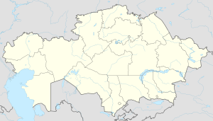
Zhanakala
Appearance
Zhanakala
Жаңақала | |
|---|---|
Town | |
 Zhanakala and the lake area where the Kushum ends | |
| Coordinates: 49°12′51″N 50°17′47″E / 49.21417°N 50.29639°E | |
| Country | |
| Region | West Kazakhstan Region |
| District | Zhanakala District |
| Population (2009) | |
• Total | 7,202 |
| Time zone | UTC+5 (UTC + 5) |
Zhanakala (Kazakh: Жаңақала, Jañaqala; Russian: Жангала) is a town in north-western Kazakhstan. It is the seat of Zhanakala District in West Kazakhstan Region. Population: 7,202 (2009 Census results);[1] 6,250 (1999 Census results).[1]
Geography
[edit]The town is located close to where the Kushum river flows into lake Birkazan.[2][3]
Climate
[edit]Zhanakala has a cold semi-arid climate (Köppen: BSk),[4] characterized by cold winters and hot summers.
| Climate data for Zhanakala (1991–2020) | |||||||||||||
|---|---|---|---|---|---|---|---|---|---|---|---|---|---|
| Month | Jan | Feb | Mar | Apr | May | Jun | Jul | Aug | Sep | Oct | Nov | Dec | Year |
| Mean daily maximum °C (°F) | −5.2 (22.6) |
−4.1 (24.6) |
4.2 (39.6) |
16.5 (61.7) |
24.8 (76.6) |
30.4 (86.7) |
32.6 (90.7) |
31.3 (88.3) |
23.8 (74.8) |
14.3 (57.7) |
3.5 (38.3) |
−3.3 (26.1) |
14.1 (57.4) |
| Daily mean °C (°F) | −8.9 (16.0) |
−8.5 (16.7) |
−0.8 (30.6) |
9.9 (49.8) |
17.9 (64.2) |
23.4 (74.1) |
25.8 (78.4) |
24.0 (75.2) |
16.6 (61.9) |
8.1 (46.6) |
−0.5 (31.1) |
−6.6 (20.1) |
8.4 (47.1) |
| Mean daily minimum °C (°F) | −12.2 (10.0) |
−12.0 (10.4) |
−4.6 (23.7) |
4.4 (39.9) |
11.6 (52.9) |
16.8 (62.2) |
19.2 (66.6) |
17.2 (63.0) |
10.2 (50.4) |
3.3 (37.9) |
−3.4 (25.9) |
−9.5 (14.9) |
3.4 (38.1) |
| Average precipitation mm (inches) | 13.0 (0.51) |
9.8 (0.39) |
15.2 (0.60) |
19.6 (0.77) |
19.7 (0.78) |
20.9 (0.82) |
19.4 (0.76) |
11.6 (0.46) |
14.4 (0.57) |
24.4 (0.96) |
16.3 (0.64) |
14.9 (0.59) |
199.2 (7.84) |
| Average precipitation days (≥ 1.0 mm) | 4.0 | 3.2 | 4.2 | 3.8 | 3.8 | 3.6 | 2.9 | 2.5 | 2.9 | 4.5 | 3.8 | 4.6 | 43.8 |
| Source: NOAA[5] | |||||||||||||
References
[edit]- ^ a b "Население Республики Казахстан" [Population of the Republic of Kazakhstan] (in Russian). Департамент социальной и демографической статистики. Retrieved 8 December 2013.
- ^ "M-39 Topographic Chart (in Russian)". Retrieved 28 February 2023.
- ^ Google Earth
- ^ "Table 1 Overview of the Köppen-Geiger climate classes including the defining criteria". Nature: Scientific Data.
- ^ "World Meteorological Organization Climate Normals for 1991-2020 — Zhanakala". National Oceanic and Atmospheric Administration. Retrieved January 19, 2024.


