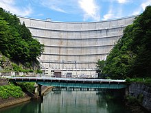
Yagisawa Dam
Appearance
You can help expand this article with text translated from the corresponding article in Japanese. (December 2008) Click [show] for important translation instructions.
|
| Yagisawa Dam | |
|---|---|
 | |
| Location | Minakami, Gunma Prefecture, Japan. |
| Coordinates | 36°54′41″N 139°03′23″E / 36.91139°N 139.05639°E |
| Construction began | 1959 |
| Opening date | 1967 |
| Dam and spillways | |
| Type of dam | Arch-Gravity |
| Impounds | Tone River |
| Height | 131 m (430 ft) |
| Length | 352 m (1,155 ft) |
| Reservoir | |
| Creates | Lake Oku-Tone |
| Total capacity | 204,300,000 m3 (7.21×10⁹ cu ft) |
| Catchment area | 167.4 km2 (64.6 sq mi) |
| Surface area | 570 hectares |
Yagisawa Dam (矢木沢ダム) is a dam in the Gunma Prefecture of Japan; it supports a 240 MW hydroelectric power station.[1]
References
[edit]- ^ "Hydropower & Dams in South and East Asia" (PDF). Hydropower and Dams. p. 9. Retrieved 3 October 2010.
Wikimedia Commons has media related to Yagisawa Dam.
