User:PenangLion/Highway sandbox
| Federal Route 3113 | |
|---|---|
| Tun Dr Lim Chong Eu Expressway | |
 | |
| Route information | |
| Maintained by the Public Works Department | |
| Length | 17.84 km (11.09 mi) |
| Time period | 1983–present |
| Major junctions | |
| North end | Weld Quay and Prangin Road Ghaut |
| South end | |
| Location | |
| Country | Malaysia |
| States | Penang |
| Districts | |
| Highway system | |
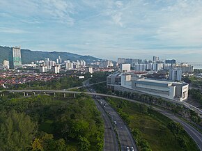
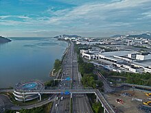
The Tun Dr Lim Chong Eu Expressway (LCE), signed as Federal Route 3113[a], is a north-south expressway in Penang. It stretches along the eastern coast of Penang Island for 17.84 kilometres (11.09 mi) from Weld Quay in George Town to Penang Route 10 at Batu Maung.[1] The expressway is the primary highway between central George Town and Bayan Lepas. It connects George Town with the Penang International Airport, the expressways E36 and E28, and links the city with its southern neighborhoods of Jelutong, Gelugor, Batu Uban, Bayan Baru and Sungai Nibong.
The main route of the LCE was constructed in stages between 1983 to 2015. It largely ran parallel to the course of Federal Route 6. The oldest section, which constituted a part of the Penang Bridge, became operational in 1985. Extensions between the late-1990s to early-2010s created two sections known as the Jelutong Expressway and the Bayan Lepas Coastal Highway. In 2011, an interchange was added to accommodate the Penang Second Bridge. The construction of the Ayer Itam–Tun Dr Lim Chong Eu Expressway Bypass is expected to link the expressway to Paya Terubong by 2025.
Route description
[edit]The LCE spans across the eastern coast of Penang Island for 17.84 kilometres (11.09 mi). It is an amalgamation of four distinct expressways – the Jelutong Expressway, an unnamed stretch under the Malaysian Highway Authority between the Penang Bridge to Jalan Tengku Kudin, the Sungai Nibong Expressway, and the Bayan Lepas Expressway.
The LCE begins at a three-way junction with Prangin Road Ghaut and Weld Quay, at the edge of George Town's city centre. It moves south and crosses the Pinang River and enters a diamond interchange with the Inner Ring Road (Jalan Sungai Pinang). The route crosses another diamond interchange with Jalan Ahmad Nor towards Jelutong, before joining the eastern terminus of Green Lane at a trumpet interchange. The route then diverges with E36 (Penang Bridge) in a three-way directional interchange, followed by a four-ramp partial cloverleaf interchange towards Federal Route 6 (Gelugor Highway).
The LCE continues southwards towards a three-way directional interchange with Pesiaran Bayan Indah at Queensbay. It is then joined with the eastern terminus of Penang Route 218 (Jalan Aziz Ibrahim) in a partial diamond interchange at the southbound direction through an unsigned exit. The expressway diverges with Federal Route 231 (Jalan Tun Dr Awang) towards the Penang International Airport with a six-ramp stack interchange through the Sungai Nibong Expressway. Afterwards the route enters an elevated section that closely follows the coastline of the Bayan Lepas Free Industrial Zone, with a junction at its underpass towards Federal Route 3114 (Kampung Jawa Avenue). The elevated section ends in a three-way directional interchange with the western terminus of E28 (Second Penang Bridge). The expressway continues south as Penang Route 10 (Batu Maung Road), which passes through Batu Maung and Permatang Damar Laut at the southernmost tip of Penang Island.
The LCE is named after Lim Chong Eu, who was Penang's chief minister between 1969 to 1990. On 26 November 2010, following Lim's death that month, the Penang state government announced the renaming of four highway sections after him.[2] A ceremony commemorating the renaming of the expressway was conducted on 7 December that year.[3] The expressway is part of the Malaysian Federal Roads System for 12.1 kilometres (7.5 mi) of its entire length, covering the majority of the Bayan Lepas Expressway. The remaining sections are maintained by the Penang Island City Council.
History
[edit]
The pioneer route for the expressway was constructed on 1983 during the Penang Bridge was built and was completed in 1985. Later, the expressway was extended northwards as the Jelutong Expressway, and southwards as the Bayan Lepas Expressway.
On 7 December 2010, after former second Penang chief minister Lim Chong Eu died on 24 November 2010, the Penang state government renamed the expressway Tun Dr Lim Chong Eu Expressway in his honour.
Construction of the 6 km (3.7 mi) long Ayer Itam–Tun Dr Lim Chong Eu Expressway Bypass, part of the Penang Transport Master Plan, is expected to be completed by 2025.[4] The bypass was designed to disperse traffic from the expressway by providing a direct route through Gelugor to Paya Terubong.[5]
Features
[edit]At most sections, the Federal Route 3113 was built under the JKR R5 road standard, allowing maximum speed limit of up to 90 km/h.
There is one overlap: Jalan Tengku Kudin–Gelugor-Penang Bridge: ![]()
![]() Penang Bridge Penang Bridge
Penang Bridge Penang Bridge
There are sections with motorcycle lanes.
Exit list
[edit]| Location | km | mi | Exit | Destinations | Notes |
|---|---|---|---|---|---|
| George Town | 0.00 | 0.00 | – | Weld Quay / Prangin Road Ghaut – Pulau Tikus | Northbound and southbound exit. |
| 0.05 | – | Magazine Road Ghaut – Komtar | Northbound and southbound entrance. | ||
| 0.15 | – | Noordin Street Ghaut – Komtar | Northbound entrance and exit, unsigned. | ||
| 0.25 | – | Presgrave Street Ghaut – Komtar | Northbound entrance and exit, unsigned. | ||
| 0.50 | – | Macallum Street Ghaut – Jelutong | – | ||
| 0.60 | – | Cecil Street Ghaut – Jelutong | – | ||
| Jelutong | 1.60 | – | Jalan Sungai Pinang east / Lebuh Sungai Pinang west – Air Itam, Jelutong, Karpal Singh Drive | – | |
| 2.25 | – | Jalan Perusahaan Jelutong – Sungai Pinang | Southbound entrance and exit; unsigned. | ||
| 3.05 | – | Jalan Ahmad Nor – Kampung Pokok Asam, Jelutong | – | ||
| Gelugor | 4.17 | – | Green Lane – Batu Lanchang, Bukit Gambir | Southbound entrance and northbound exit. | |
| 5.80 | – | Western terminus of E36; access to FT 6 via Jalan Sultan Azlan Shah. | |||
| 7.70 | Jalan Batu Uban – Batu Uban | Northbound entrance and exit. | |||
| 8.10 | – | Persiaran Bayan Indah – Queensbay | – | ||
| 8.97 | – | Eastern terminus of P218; southbound entrance and exit; access via unsigned exit. | |||
| Bayan Lepas | 9.30 | – | Eastern terminus of FT 231; access via Sungai Nibong Expressway. | ||
| 10.60 | – | Jalan Kampung Jawa – Bayan Lepas Free Industrial Zone | – | ||
| 12.06 | – | Eastern terminus of FT 3114. | |||
| 13.47 | – | Hilir Sungai Kluang 1 – Bayan Lepas Free Industrial Zone | – | ||
| 14.18 | – | Western terminus of E28. | |||
| 17.84 | 11.09 | – | Eastern terminus of P10. | ||
| 1.000 km = 0.621 mi; 1.000 mi = 1.609 km
Incomplete access | |||||
See also
[edit]Notes
[edit]- ^ The designation applies to the Bayan Lepas Expressway only.
References
[edit]- ^ Statistik Jalan (Edisi 2014). Kuala Lumpur: Malaysian Public Works Department. 2014. p. 57. ISSN 1985-9619.
- ^ Penang has renamed a highway as Tun Dr Lim Chong Eu expressway The Star, November 26, 2010
- ^ Expressway renamed to honour Chong Eu The Star, December 7, 2010
- ^ "5.7km bypass on island now 42% complete". The Star. 2 Mar 2024. Retrieved 6 Mar 2024.
- ^ "Bypass now 33% completed". The Star. Retrieved 2024-02-28.


