User:Ateivis/sandbox
Pegasus Airlines Flight 2193 ( Meteorological analysis )
[edit]DATE: Wednesday, 5 February, 2020
[edit]TIME: 18:19 (Local time)
[edit]TYPE: Boeing 737-86J (WL)
[edit]OPERATOR: Pegasus Airlines
[edit]REGISTRATION: TC-IZK
[edit]FIRST FLIGHT: 2009-01-23 (14 years ago)
[edit]CREW: Fatalities: 0 / Occupants: 6
[edit]PASSENGERS: Fatalities: 3 / Occupants: 177
[edit]TOTAL: Fatalities: 3 / Occupants: 183
[edit]AIRCRAFT DAMAGE: Destroyed
[edit]AIRCRAFT FATE: Written off (damaged beyond repair)
[edit]PHASE: Landing (LDG)
[edit]DEPARTURE: Izmir-Adnan Menderes Airport (ADB/LTBJ), Turkey
[edit]DESTINATION: Istanbul - Sabiha Gökçen International Airport (SAW/LTFJ), Turkey
[edit]FLIGHT NUMBER: PC2193
[edit]General information
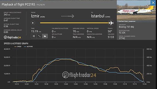
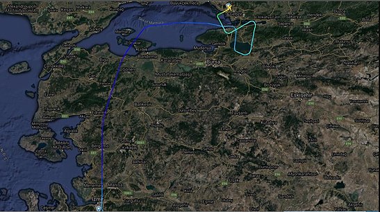
[edit]Boeing 737-800, registration TC-IZK performing flight PC-2193 from Izmir to Istanbul Sabiha Gokcen (Turkey) with 177 passengers and 6 crew, landed on Sabiha Gokcen's airport.
The aircraft departed Izmir Airport at 17:22 hours. At the time the aircraft arrived in Istanbul-Sabiha Gökçen Airport, a thunderstorm was passing. Runway in use was 06. About 18:17 the Tower controller cleared another flight for takeoff from runway 06, reporting wind 300 degrees at 11 knots, gusting to 21 knots. The subsequent arrival was flight 2193, which was cleared to land with wind information given as 270 degrees at 22 knots, gusting to 30 knots which was 19 knot tailwind. Since the wind was shifting the controller reported to the aircrafts on the ground that it was to expect a runway change for departure.
At 18:19 Pegasus 2193 touched down, but failed to complete a full stop on the runway. It overran and went down an embankment, breaking into three. The aircraft came to rest about 30 m below runway elevation.
Data from flight tracking website Flightradar24 shows that the aircraft was steered to the left at the end of the runway, likely as there was an antenna array just past the stop way. The last recorded ground speed was 63 knots as the aircraft crossed the perimeter road.
During the crash one of the engines had separated and caught fire. As of current rescue and recovery works are in progress, the engine fire was quickly extinguished.
On April 28th 2020 the NTSB reported the occurrence was rate an accident and is being investigated by the Government of Turkey. Three occupants died, 19 received serious injuries and 161 received minor injuries.
States Attorney report
[edit]According to the States Attorney the report states that the accident was "predictable and preventable". The aircraft had received a lightning strike earlier into the flight causing stress to the captain, who wanted to get the aircraft onto the ground as quickly as possible. The approach to runway 06 became unstable with too high speed in addition to strong tail wind, tower did not instruct a go around. After touch down the captain disabled automatic brakes and speed brakes when he believed the aircraft had slowed sufficiently, the aircraft did not experience deceleration for about 6 seconds as result before manual braking was applied causing the main wheels to hydroplane. The aircraft crossed the runway end at 57 knots and impacted the airport perimeter wall causing 3 fatalities and 180 injuries. The report also states that the co-pilot, with 400 hours total flight time, did not call out various deviations (e.g. speed, sink rate, etc.) during the final approach and did not call for a go around. Part of the blame also goes to the tower, who believed the landing was risky but cleared the flight to land and did not instruct a go around. The lack of a runway end safety area contributed to the accident and in particular to the severity of the accident.
ROUTE
[edit]The route flown by the aircraft was as follows:
- The flight had a scheduled departure time of 4:45 PM local time, but it was delayed by over an hour and eventually took off at 5:50 PM.
- The aircraft took off from runway 35R at Izmir Adnan Menderes Airport (ICAO code: LTBJ) at 5:50 PM local time on February 5, 2020.
- The distance between Izmir Adnan Menderes Airport and Istanbul Sabiha Gökçen International Airport is approximately 307 miles (494 kilometers).
- It climbed to its cruising altitude of 36,000 feet and maintained this altitude for the duration of the flight.
- After approximately 45 minutes of flight time, the aircraft began to descent into Istanbul Sabiha Gökçen International Airport.
- The aircraft entered the final approach for runway 06 at Sabiha Gökçen, which is a long, wide runway that is over 3,000 meters in length.
- The flight had a normal descent and approach until the final moments before landing, when it suddenly lost altitude and touched down hard on the runway, causing the accident.
METAR
[edit]Published 28 minutes before #PC2193 landed:
[edit]LTFJ 051450Z VRB08G18KT 9999 -SHRA FEW025CB BKN036 BKN070 12/09 Q0990 NOSIG=
LTFJ 4 character ICAO airport identifier
051450Z Day: 05; Time: 14:50 UTC
VRB08G18KT Wind Direction: VRB Speed: 08KT, Gusts: 18KT
9999 Visibility 9999 meters
-SHRA Light (-) Showers (SH) Rain (RA)
FEW025CB Few (FEW) 2,500ft AGL Cumulonimbus
BKN036 Broken (BKN) 3,600ft AGL
BKN070 Broken (BKN) 7,000ft AGL
12/09 Temperature: 12 °C Dewpoint: 9 °C
Q0990 Air pressure is 0990 hpa
NOSIG= No significant change is expected to the reported conditions within the next 2 hours
Published 2 minutes after the crash:
[edit]LTFJ 051520Z 29022G37KT 240V330 7000 -TSRA FEW017CB BKN025 BKN070 11/09 Q0992 RESHRA NOSIG=
LTFJ 4 character ICAO airport identifier
051520Z Day: 05; Time: 15:20 UTC
29022G37KT Wind Direction: 290 Speed: 22KT, Gusts: 37KT
240V330 Direction is variable between 240 and 330
7000 Visibility 7000 meters
-TSRA Light (-) Thunderstorm (TS) Rain (RA)
FEW017CB Few (FEW) 1,700ft AGL Cumulonimbus
BKN025 Broken (BKN) 2,500ft AGL
BKN070 Broken (BKN) 7,000ft AGL
11/09 Temperature: 11 °C Dew point: 9 °C
Q0992 Air pressure is 0992Hpa
RESHRA Recent (RE) Showers (SH) Rain (RA)
NOSIG= No significant change is expected to the reported conditions within the next 2 hour.
TAF
[edit]05/02/2020 16:40 UTC TAF
[edit]TAF LTFJ 051640Z 0518/0618 24009KT 7000 - SHRA SCT012 BKN030
TEMPO 0518/0522 29015G27KT 4000 SHRA FEW020CB BKN025
BECMG 0605/0608 35015KT
BECMG 0608/0611 35019G29KT -SHRASN=
LTFJ - 4 character ICAO airport identifier
051640Z - Day: 05; Time: 16:40 UTC
0518/0618 - Valid Time Period: Starts at Day:05; 18:00 UTC Ends at Day:06; 18:00 UTC
24009KT - Wind Direction: 240 Speed: 09KT
7000 - Visibility 7000 meters
-SHRA - Light(-) Showers(SH) Rain(RA)
SCT012 - Scattered (SCT) 1,200ft AGL
BKN030 - Broken (BKN) 3,000ft AGL
TEMPO 0518/0522 - Conditions are expected to change temporarily between Day:05; 18:00 and Day:05; 22:00 UTC
29015G27KT - Wind Direction: 290 Speed: 15KT, Gusts: 27KT
4000 - Visibility 4000 meters
SHRA - Showers(SH) Rain(RA)
FEW020CB - Few (FEW) 2,000ft AGL Cumulonimbus
BKN025 - Broken (BKN) 2,500ft AGL
BECMG 0605/0608 - Conditions are expected to change gradualy between Day:06; 05:00 and Day:06 08:00 UTC
Wind Direction - 350 Speed: 15KT
35015KT - Wind Direction: 350 Speed: 15KT
BECMG 0608/0611 - Conditions are expected to change gradualy between Day:06; 08:00 and Day:06 11:00 UTC
35019G29KT - Wind Direction: 350 Speed: 19KT, Gusts: 29KT
-SHRASN= - Light(-) Showers(SH) Rain(RA) Snow(SN)
Meteorological conditions
[edit]Temperature on Wednesday, February 5, 2020 at Sabiha Gökçen International Airport
[edit]Cloud Cover on Wednesday, February 5, 2020 at Sabiha Gökçen International Airport
[edit]Dew Point on Wednesday, February 5, 2020 at Sabiha Gökçen International Airport
[edit]Wind Speed on Wednesday, February 5, 2020 at Sabiha Gökçen International Airport
[edit]Wind Direction on Wednesday, February 5, 2020 at Sabiha Gökçen International Airport
[edit]Visibility on Wednesday, February 5, 2020 at Sabiha Gökçen International Airport
[edit]Atmospheric Pressure on Wednesday, February 5, 2020 at Sabiha Gökçen International Airport
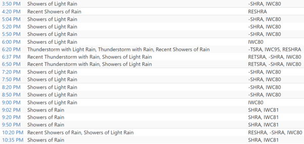
[edit]WEATHER TIMELINE:
[edit]Thunderstorm Formation and Aviation Hazards
[edit]Thunderstorms are one of the most beautiful atmospheric phenomenon. As a pilot, however, thunderstorms are one of the most hazardous conditions you can encounter. All thunderstorms can produce severe turbulence, low level wind shear, low ceilings and visibilities, hail and lightning. Each of these hazards can be difficult to cope with; if all these conditions arrive at once, it can be disastrous.
Thunderstorms are formed by a process called convection, defined as the transport of heat energy. Because the atmosphere is heated unevenly, an imbalance can occur which thunderstorms attempt to correct. Three things are needed for convection to be a significant hazard to flight safety: moisture, lift and instability.
Hazards Associated with Thunderstorms:
[edit]It is wise to avoid thunderstorms, as a flight instructor once said “A thunderstorm is never as bad inside as it looks from the outside—it is worse.” Thunderstorms contain many hazards to aviation such as the following:
Lightning:
[edit]By definition, all thunderstorms contain lightning. Although the NWS will mention lightning as a hazard in some warning products, lightning is not a criteria used to determine if a thunderstorm is severe. As an aviator, you should be aware that lightning can strike more than 10 miles from a thunderstorm.
Turbulence:
[edit]Pilot reports from aircraft encountering thunderstorms have noted up and down drafts exceeding 6000 feet per minute. Turbulence exceeding the performance capability of most aircraft can be found in and around thunderstorms.
Wind Shear:
[edit]Thunderstorm outflow can cause extreme changes in wind speed and direction near the surface during critical phases of flight. Microbursts are possible with many thunderstorms, as is heavy rain. Often virga and blowing dust on the surface are your only clues to the presence of a microburst.
Icing:
[edit]Because thunderstorms are driven, in part, from the conversion of liquid water to ice, pilots can expect to find airframe icing in all thunderstorms. Although all forms of icing are possible, clear icing, caused by larger drops of supercooled water, is the most common. Ice accumulation can be rapid. Supercooled water and clear icing can extend to great heights and to temperatures as low as -20o C.
SKEW-T
[edit]Skew-T is a type of atmospheric sounding diagram that is commonly used by meteorologists and other atmospheric scientists to analyze the vertical structure of the atmosphere. The name "Skew-T" comes from the fact that the temperature and dew point lines on the diagram are skewed at a 45-degree angle.
To read a Skew-T diagram, you first need to understand the basic structure of the diagram. The vertical axis of the diagram represents pressure, with higher pressure at the bottom and lower pressure at the top. The horizontal axis represents temperature, with warmer temperatures towards the right and cooler temperatures towards the left.
The Skew-T diagram includes several lines that are important for understanding atmospheric conditions. Example of Skew-T:
The red on the right represents the temperature profile of the atmosphere. The green light on the left represents Dew Point profile. If at any point the Dew Point and Temperatures meet, this is where the air is saturated ant you likely have clouds and that is called LCL.
The LCL is an important parameter for meteorologists because it gives an indication of the lowest height at which clouds are likely to form in the atmosphere. In addition, the height of the LCL can be used to estimate the cloud base height, which is an important factor in forecasting weather conditions.
The Skew-T diagram allows meteorologists to determine the LCL by examining the temperature and dew point profiles of the atmosphere and identifying the intersection point of the two lines. The height of the LCL can then be determined using the pressure and temperature scales on the diagram.
Overall, the LCL is an important parameter for understanding the vertical structure of the atmosphere and is often used in weather forecasting and analysis.
The Skew-T diagram from the CRASH DAY on 5th January, 2020:
[edit]In our Skew-T diagram we can see all those lines we just mentioned few moments ago, but not all the lines have colors. Let’s imagine, that the black line on the left is GREEN and the black line on the RIGHT is the red one. As you can see between altitudes 16020 and 11570 the distance between the lines is quite large, so it is likely that there is minimal or no cloud cover at those altitudes. Going down, the distance between the lines suddenly begins to decrease and already at 10,000 meters the lines are quite close to each other and this distance is maintained with small deviations up to an altitude of about 6,000 meters. At about 5,400 meters, the lines approach each other maximally and begin to cross in places to identify very high cloud cover and poor weather conditions for the descending aircraft. In our diagram we can see two LCL positions that is at 5400m and at 3000 meters.
Conclusion
[edit]Summing up why the accident happened, it is impossible to name one reason, because many of them happened at the same time. As mentioned earlier, the aircraft had received a lightning strike earlier into the flight causing stress to the captain, who wanted to get the aircraft onto the ground as quickly as possible. The approach to runway 06 became unstable with too high speed in addition to strong tail wind, tower did not instruct a go around. The co-pilot, with 400 hours total flight time, did not call out various deviations (e.g. speed, sink rate, etc.) during the final approach and did not call for a go around. Part of the blame also goes to the tower, who believed the landing was risky but cleared the flight to land and did not instruct a go around. So, although there are many reasons why the accident happened, one of the main ones that laid the foundation for this accident is bad weather conditions.


