
User:Ɱ/Portal:Columbus, Ohio
Portal maintenance status: (October 2021)
|
Introduction

Columbus (/kəˈlʌmbəs/, kə-LUM-bəs) is the capital and most populous city of the U.S. state of Ohio. With a 2020 census population of 905,748, it is the 14th-most populous city in the U.S., the second-most populous city in the Midwest (after only Chicago), and the third-most populous U.S. state capital, after only Phoenix, Arizona and Austin, Texas. Columbus is the seat of government of Franklin County; it also extends into Delaware and Fairfield counties. It is the core city of the Columbus metropolitan area, which encompasses ten counties in central Ohio. It had a population of 2,138,926 in 2020, making it the largest metropolitan area entirely in Ohio and 32nd-largest metro area in the U.S.
Columbus originated as numerous Native American settlements on the banks of the Scioto River. Franklinton, now a city neighborhood, was the first European settlement, laid out in 1797. The city was founded in 1812 at the confluence of the Scioto and Olentangy rivers, and laid out to become the state capital. The city was named for Italian explorer Christopher Columbus. The city assumed the function of state capital in 1816 and county seat in 1824. Amid steady years of growth and industrialization, the city has experienced numerous floods and recessions. Beginning in the 1950s, Columbus began to experience significant growth; it became the largest city in Ohio in land and population by the early 1990s. Growth has continued in the 21st century, with redevelopment occurring in numerous city neighborhoods, including Downtown. (Full article...)
Selected general articles
-
 Zoombezi Bay (/zuːmˌbiːzi ˈbeɪ/) is a 22.7-acre (9.2 ha) water park owned by the Columbus Zoo and Aquarium near Powell, Ohio just north of Columbus. The park sits on the site of the former Wyandot Lake Adventure Park, which was purchased by the Columbus Zoo and Aquarium in 2006. Zoombezi Bay opened to the public on May 26, 2008, and currently ranks as one of the Midwest's most popular water parks, attracting more than 400,000 visitors annually. (Full article...)
 -
The Columbus Destroyers were an Arena Football League (AFL) team based in Columbus, Ohio, with home games in Nationwide Arena. The team was founded in 1999 as the Buffalo Destroyers, based in Buffalo, New York, and relocated to Columbus in 2004. They folded along with the original incarnation of the AFL following the 2008 season, after a total of ten seasons of play.
On February 7, 2019, the AFL announced that it had placed an expansion team in Columbus and once again play at Nationwide Arena. The league announced on February 22, 2019, that the team as a re-launch of the Destroyers and revealed the new logo and Matthew Sauk as the head coach.
After the 2019 season, the AFL announced that they had suspended local business operations including the Destroyers, but were looking into become a traveling league. A month later, on November 27, 2019, the league announced that they had filed for Chapter 7 bankruptcy and were ceasing operations. (Full article...) -

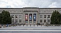
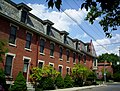
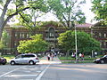
The Franklin County Government Center
The Franklin County Government Center is a government complex of Franklin County, Ohio in the city of Columbus. The government center has included several iterations of the Franklin County Courthouse, including a building completed in 1840 and another completed in 1887. Current courthouse functions are spread out between buildings in the complex. (Full article...) -
Driving Park is an urban residential area on the Near East Side of Columbus, Ohio just south of Interstate 70. Mainly a middle-class, predominantly African American neighborhood, Driving Park and its surrounding neighborhoods consist of an area of 17,730 residents. Driving Park received its name from its historic past as a large racing complex, first for horses and later for automobiles. (Full article...) -
The Columbus Blue Birds were a professional Negro league baseball team based in Columbus, Ohio in 1931 and 1933. (Full article...) -

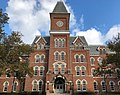
The Ohio State Buckeyes are the intercollegiate athletic teams that represent Ohio State University, located in Columbus, Ohio. The athletic programs are named after the colloquial term for people from the state of Ohio and after the state tree, the Ohio buckeye. The Buckeyes participate in the National Collegiate Athletic Association's (NCAA) Division I in all sports and the Big Ten Conference in most sports. The Ohio State women's ice hockey team competes in the Western Collegiate Hockey Association (WCHA). The school colors are scarlet and gray. The university's mascot is Brutus Buckeye. "THE" is the official trademark of the Ohio State University merchandise. Led by its gridiron program, the Buckeyes have the largest overall sports endowment of any campus in North America.
Ohio State is one of only seven universities to have won an NCAA national championship in baseball and men's basketball, and be recognized as a national champion in football. Ohio State has also won national championships in women's ice hockey, men's swimming & diving, men's outdoor track & field, men's volleyball, men's golf, men's gymnastics, men's fencing, women's rowing, co-ed fencing, co-ed and women's pistol, synchronized swimming, and wrestling. Since the inception of the Athletic Director's Cup, Ohio State has finished in the top 25 each year, including top 6 finishes in three of the last five years. During the 2005–06 school year Ohio State became the first Big Ten team to win conference championships in football, men's basketball and women's basketball in the same season. This feat repeated in the 2006–07 season, which also included a February 25, 2007 men's basketball game which saw the Buckeyes defeat the Wisconsin Badgers in the Big Ten's first basketball game between the number one and number two ranked squads in the nation.
A few of the many outstanding sports figures who were student athletes at Ohio State include Jesse Owens, "The Buckeye Bullet" (track and field), John Havlicek, Jerry Lucas, and Katie Smith (basketball), Frank Howard (baseball), Jack Nicklaus (golf), Archie Griffin (football running back, the only two-time Heisman Trophy winner), and Chic Harley (three-time All-American football running back). Hall of Fame coaches at Ohio State have included Paul Brown and Woody Hayes (football), Fred Taylor (men's basketball). Notable sports figures in Ohio State history may be inducted into the Ohio State Varsity O Hall of Fame. (Full article...) -
The Arena District is a mixed-use planned development and neighborhood in Columbus, Ohio. The site was developed through a partnership between Nationwide Realty Investors, Ltd. (a subsidiary of Nationwide), the City of Columbus and private investors. Interpretation of the boundaries of the district are evolving as the neighboring blocks around the original 75-acre (300,000 m2) site have seen additional commercial and residential development. The Arena District is named for Nationwide Arena. (Full article...) -

The Michael B. Coleman Government Center is a municipal office building of Columbus, Ohio, in the city's downtown Civic Center. The building, completed in 2018, is named for former mayor Michael Coleman. (Full article...) -
Franklin Park is a neighborhood located on the Near East Side of Columbus, Ohio. Both the historic neighborhood and landmark, the Franklin Park Conservatory and Botanical Gardens, are named after the 88-acre park. (Full article...) -
Mount Vernon is a predominantly African-American historic neighborhood in Columbus, Ohio, United States. The neighborhood lies within the historic Near East Side community, north of King-Lincoln Bronzeville. Mount Vernon borders Interstates 71 and 670. Its main thoroughfares, Mount Vernon Avenue, Long Street, Atcheson Street, and Champion Avenue define the community's limits.
The neighborhood is named for Mount Vernon Avenue, the center of a once-thriving economy. In the 19th century into the 1970s, the area (including the present-day King-Lincoln Bronzeville) held thousands of Black families and businesses, with a variety of businesses lining the avenue. It was during an era of segregation and isolation for the community, and thus Black families were self-sustaining in the area. Beginning in the 1950s, interstate highways were constructed in Columbus. The highways physically divided parts of the neighborhood and their large land uses forced families and businesses to relocate, leading to more vacancies and an overall neighborhood decline.
The Leonard Pearl Henderson House in the neighborhood is a historically-significant house near an Ohio State University medical center. The building was proposed for demolition in 2023. (Full article...) -
Racism is a prevailing issue in the city of Columbus, Ohio, United States. Minority groups may face some societal, health, and legal challenges not experienced by non-minority residents.
Racism was recognized as a public health crisis in Columbus and its surrounding county, Franklin County, in 2020. (Full article...) -
East Columbus (East Side) is a very large area in Columbus, Ohio. It can be defined as the area bounded by Interstate 70, Interstate 670, and the eastern city limits that stretch miles outside the city outerbelt (Interstate 270). Generally, the East Side is separate from the Near East Side (Near East Side, Columbus, Ohio), with the Near East Side being the area closer to Downtown Columbus. (Full article...)
-

Cristo Rey Columbus High School (CRCHS or CRC) is a private, Roman Catholic, co-educational high school in Columbus, Ohio, United States. It was established in 2013 and is located in the Roman Catholic Diocese of Columbus. It follows the Cristo Rey work-study model of education for students from low-income families. (Full article...) -
The Columbus Register of Historic Properties is a register for historic buildings and other sites in Columbus, Ohio, United States. The register is maintained by the City of Columbus Historic Resources Commission and Historic Preservation Office, and was established in 1980. Many of these landmarks are also listed on the National Register of Historic Places, providing federal tax support for preservation, and some are further designated National Historic Landmarks, providing additional federal oversight.
The Columbus Register includes 82 entries, including 54 on the National Register. Two of the city's three National Historic Landmarks are on the register: the Ohio Statehouse and Captain Edward V. Rickenbacker House, but not the Ohio Theatre. The city also maintains four historic districts not listed on its register: German Village, Italian Village, Victorian Village, and the Brewery District. (Full article...) -
The Columbus Streetcar was a proposed streetcar system to be located in and around Downtown Columbus, Ohio. Initially planned to run along High Street, the line would have run for 2.8 miles (4.5 km) and connected the Ohio State campus with the Franklin County Government Center. As of February 2009, the plan was indefinitely on hold. Discussion took place for a larger scale light rail system which would run along the streetcar route and also connect the northern part of the city to downtown. In 2014, the CBUS free circulator bus began operation on much of the proposed streetcar route. (Full article...)
-
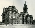
Columbus City Hall is the city hall of Columbus, Ohio, in the city's downtown Civic Center. It contains the offices of the city's mayor, auditor, and treasurer, and the offices and chambers of Columbus City Council.
City Hall was designed in a Neoclassical style by the Allied Architects Association of Columbus. It replaced offices in the Central Market building as well as a former permanent city hall. The new city hall was built from 1926 to 1928, during a period of extensive construction building the city's riverfront civic center. An additional wing was added to City Hall in 1936. Renovations took place in 1949 and 1986, and the building was determined to be eligible for the National Register of Historic Places as part of a historic district in 1988. (Full article...) -
-
The Oakland & Northwood Avenue Area (sometimes referred to as Northwood Park) is located in the northern University District in Columbus, Ohio and is bounded by Patterson Avenue to the north and Northwood Avenue to the south & Pearl Alley to the west and Indianola Avenue to the east . It is sometimes considered to go as far north as Blake Ave.
The Northwood & Oakland Avenue Area was settled between the early 1900s and the 1940s, making it one of the first subdivisions to be built on the then "outskirts" of the City of Columbus. The homes are traditionally American Four Square with some Classical, Prairie, Colonial, and Craftsman mixed in to create a unique tree lined neighborhood.
The neighborhood is known for its strong sense of community, large homes, beautiful gardens and brick alleys. It also has a very high percentage of owner-occupancy. (Full article...) -
Blacklick Estates is a census-designated place (CDP) in Franklin County, Ohio, United States: partly in Madison Township and partly in Truro Township. As of the 2020 census the population was 8,990. (Full article...)
-
The culture of Columbus, Ohio, is particularly known for museums, performing arts, sporting events, seasonal fairs and festivals, and architecture of various styles from Greek Revival to modern architecture. (Full article...)
-
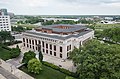
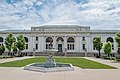
The Main Library of the Columbus Metropolitan Library (CML) system is located in Downtown Columbus, Ohio, United States. The public library is the largest in the library system and holds approximately 300,000 volumes. It includes numerous rooms, including separate spaces for children, teens, an adult reading room, newspaper room, auditorium, gallery, gift shop, and a cafe. The third floor includes a computer lab and houses the Franklin County Genealogical & Historical Society.
The library building was proposed as early as 1901 when the public used a reading room in Columbus's city hall. In 1903, Andrew Carnegie largely funded its construction, making it a Carnegie library. The library was designed by Albert Randolph Ross in the Beaux-Arts style, using white Vermont marble. The building opened in 1907. It was first expanded in 1953 and 1961, followed by a 1991 addition and the demolition of the two prior structures; the process tripled the building's size. In 2015 and 2016, another renovation took place to increase reader space, add to its west lawn, join the building to Topiary Park at its east, and clad most of the 1991 building in glass. (Full article...) -
The Ohio Statehouse is the state capitol building and seat of government for the U.S. state of Ohio. The Greek Revival building is located on Capitol Square in Downtown Columbus. The capitol houses the Ohio General Assembly, consisting of the House of Representatives and the Senate. It also contains the ceremonial offices of the governor, lieutenant governor, state treasurer, and state auditor. Built between 1839 and 1861, it is one of the oldest working statehouses in the United States. The statehouse grounds include two other buildings, the Judiciary Annex or Senate Building, and the Atrium; the three are collectively referred to as the Ohio Statehouse into the present day.
The statehouse's prominent architecture has earned it several landmark designations, including as a National Historic Landmark. The building sees about 500,000 visitors per year. (Full article...) -
Lincoln Village is a census-designated place (CDP) in Prairie Township, Franklin County, Ohio, United States. It is centered near the intersection of US 40 and I-270 on the west side of Columbus. As of the 2020 census, the population was 9,702.
Lincoln Village was started in 1955 as a planned community by a real estate subsidiary of Nationwide Insurance. (Full article...) -
The Jack Nicklaus Museum is a museum focused on and honoring championship golfer Jack Nicklaus. It is on the campus of the golfer's alma mater of Ohio State University in his hometown of Columbus, Ohio.
The museum, opened in 2002, is a 24,000-square-foot (2,200 m2) facility offering a comprehensive view of Nicklaus' life and career in and out of golf as well as exhibits celebrating the history and legends of the game. In 2005, it was transferred by the private Jack Nicklaus Museum Inc. to Ohio State University.
It houses three theaters, a golf shop and a number of exhibit galleries. (Full article...) -
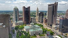
Capitol Square is a public square in Downtown Columbus, Ohio. The square includes the Ohio Statehouse, its 10-acre (4.0 ha) Capitol Grounds, as well as the buildings and features surrounding the square. The Capitol Grounds are surrounded to the north and west by Broad and High Streets. These are the main thoroughfares of the city since its founding. They form the city's 100 percent corner. The grounds are surrounded by 3rd Street to the east and State Street to the south. The oldest building on Capitol Square, the Ohio Statehouse, is the center of the state government and roughly in the geographic center of Capitol Square, Columbus and Ohio. (Full article...)


.jpeg)

Need help?
Do you have a question about Columbus, Ohio that you can't find the answer to?
Consider asking it at the Wikipedia reference desk.
Selected images
-
 Map of the Ohio Country between 1775 and 1794, depicting locations of battles and massacres surrounding the area that would eventually become the U.S. state of Ohio (from Columbus, Ohio)
 -
-
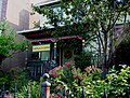
 Dutch Colonial Style residences in Hungarian Village (from Neighborhoods in Columbus, Ohio)
 -
 The Columbus Museum of Art collects and exhibits American and European modern and contemporary art, folk art, glass art, and photography. (from Columbus, Ohio)
 -
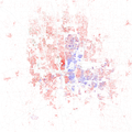 Racial distribution in Columbus in 2010: ⬤ White ⬤ Black ⬤ Asian ⬤ Hispanic ⬤ Other (from Columbus, Ohio)
 -
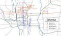 Locations of numbered streets and avenues (from Columbus, Ohio)
 -
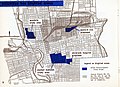 1954 urban renewal map of Columbus (from List of demolished buildings and structures in Columbus, Ohio)
 -
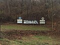 Hilltop signage (from Neighborhoods in Columbus, Ohio)
 -
-
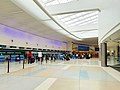 John Glenn Columbus International Airport departure level (from Columbus, Ohio)
 -
 Victorian houses facing Goodale Park in Victorian Village (from Columbus, Ohio)
 -
 West Broad Street in Franklinton (from Neighborhoods in Columbus, Ohio)
 -
-
 The historic Lincoln Theatre (from Neighborhoods in Columbus, Ohio)
 -
 COSI (east entrance pictured) features themed, interactive science exhibits. (from Columbus, Ohio)
 -

-
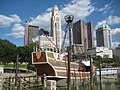 The Santa Maria Ship & Museum, a Santa María replica, was docked downtown from 1991 to 2014. (from Columbus, Ohio)
 -
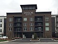 Taylor House on Bethel Rd. (from Neighborhoods in Columbus, Ohio)
 -
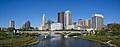 Panorama of downtown Columbus from the Main Street Bridge (from Columbus, Ohio)
 -
-
-
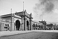
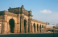 Arcade of the third Union Station, the city's rail station from 1897 to 1977 (from Columbus, Ohio)
 -
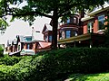 Victorian-style homes located along Goodale Park (from Neighborhoods in Columbus, Ohio)
 -
 Italian Village rowhouse (from Neighborhoods in Columbus, Ohio)
 -
 Audubon nature center at Scioto Audubon Metro Park, the first built close to a major city's downtown (from Columbus, Ohio)
 -
-
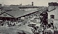 Central Market stood on Fourth Street from 1850 to 1966 (from History of Columbus, Ohio)
 -
 Brewery District Scene (from Neighborhoods in Columbus, Ohio)
 -
-
 Columbus City Hall (from Columbus, Ohio)
 -
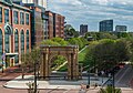
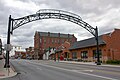 Old North Columbus Arch (from Neighborhoods in Columbus, Ohio)
 -
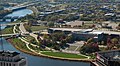
 Located in the Arena District, McFerson Commons is home to the Union Station arch. (from Columbus, Ohio)
 -
 The LeVeque Tower was the tallest building in Columbus from 1927 to 1973. (from List of tallest buildings in Columbus, Ohio)
 -
-

-
 The Pontifical College Josephinum (1888-1931) (from List of demolished buildings and structures in Columbus, Ohio)
 -
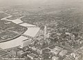
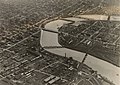 Downtown Columbus and the Scioto River c. 1924 (from Columbus, Ohio)
 -
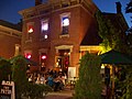
 Barlouie (from Neighborhoods in Columbus, Ohio)
 -
Central Market, pictured here in 1898, operated from 1814 to 1966. (from Columbus, Ohio)
-
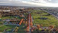
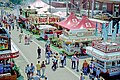 The Ohio State Fair is held in late July to early August. (from Columbus, Ohio)
 -
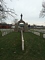 Camp Chase as it stands today, a memorial to fallen soldiers from the American Civil War. (from Neighborhoods in Columbus, Ohio)
 -
-
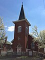 Hungarian Reform Church, in Hungarian Village (from Neighborhoods in Columbus, Ohio)
 -
 Columbus in 1936 (from History of Columbus, Ohio)
 -
 Homes in German Village (from Neighborhoods in Columbus, Ohio)
 -
 Municipal offices, including the Columbus Division of Police Headquarters, in the city's Civic Center (from Columbus, Ohio)
 -
 Skyline of Columbus (Use cursor to identify buildings) (from List of tallest buildings in Columbus, Ohio)
 -
-
-
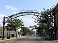
 Street arches returned to the Short North in late 2002. (from History of Columbus, Ohio)
 -
2010 Census-based map: red dots indicate white Americans, blue dots for African Americans, green for Asian Americans, orange for Hispanic Americans, yellow for other races. Each dot represents 25 residents. (from Neighborhoods in Columbus, Ohio)
-
The city c. 1924 (from History of Columbus, Ohio)
-
-
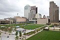
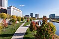
 The Scioto Mile includes nine parks along both banks of the Scioto River between downtown Columbus and Franklinton. (from Columbus, Ohio)
 -
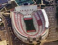 Ohio Stadium, on the campus of Ohio State University, is the 5th-largest non-racing stadium in the world. (from Columbus, Ohio)
 -
 Four of the city's five tallest buildings are around Capitol Square (from List of tallest buildings in Columbus, Ohio)
 -
Map of the Ohio Country between 1775 and 1794, depicting locations of battles and massacres surrounding the area that would eventually become Ohio (from History of Columbus, Ohio)
-
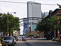
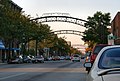 The iconic arches of the Short North (from Neighborhoods in Columbus, Ohio)
 -
-
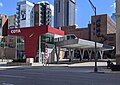 COTA's Spring Street Terminal, one of its five transit centers (from Columbus, Ohio)
 -
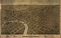 Bird's eye view map of Columbus in 1872 (from Columbus, Ohio)
 -

-
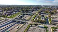
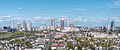
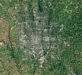 Aerial satellite image of Columbus (from Columbus, Ohio)
 -
-
 Aerial view of Reeb-Hosack (from Neighborhoods in Columbus, Ohio)
 -

-
 Indianola Junior High School was the first middle school in the U.S. (from Columbus, Ohio)
 -
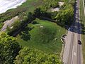 Shrum Mound, the feature of Campbell Memorial Park (from History of Columbus, Ohio)
 -
 View of the city from Capital University in 1854 (from Columbus, Ohio)
 -
 Lou Berliner Sports Park (from List of parks in Columbus, Ohio)
 -
Bird's eye view map of Columbus in 1872 (from History of Columbus, Ohio)
-
Shrum Mound in Campbell Memorial Park (from Columbus, Ohio)
-
 Home in Old Oaks (from Neighborhoods in Columbus, Ohio)
 -
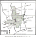 Map of land surveys and city boundary growth, 1812–1920 (from History of Columbus, Ohio)
 -
-
 The Merion Village arch (from Neighborhoods in Columbus, Ohio)
 -
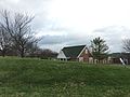
 Big Run Sports Complex, in Big Run Park (from Neighborhoods in Columbus, Ohio)
 -
 Port Columbus Airport tower and terminal from 1929 to 1958 (from Columbus, Ohio)
 -
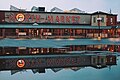 North Market (from Columbus, Ohio)
 -
View of the city from Capital University in 1854 (from History of Columbus, Ohio)
-
-

-
 Holy Rosary and Saint John Church (from Neighborhoods in Columbus, Ohio)
 -
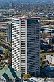
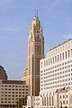
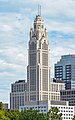 The Art Deco LeVeque Tower is the city's second-tallest skyscraper. (from Columbus, Ohio)
 -
-

-
 St. Mary Magdalene Church in Westgate (from Neighborhoods in Columbus, Ohio)
 -
The city in 1936 (from Columbus, Ohio)
-
 Historic Home in Harrison West (from Neighborhoods in Columbus, Ohio)
 -
 Eastern side of Olentangy Commons (from Neighborhoods in Columbus, Ohio)
 -
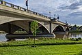 The Discovery Bridge (from Columbus, Ohio)


.png)


.jpg)


.jpg)


.jpg)


_crop.jpg)


.jpg)

.jpg)


_-_exterior_2.jpg)


Subcategories

- Select [►] to view subcategories
Subtopics
| Topics |  | ||||||
|---|---|---|---|---|---|---|---|
| Neighborhoods | |||||||
| Enclaves | |||||||
| History |
| ||||||
| Attractions | |||||||
| Government |
| ||||||
| Education |
| ||||||
| Transportation |
| ||||||
| Sports |
| ||||||
| Museums |
| ||||||
| |||||||
Associated Wikimedia
The following Wikimedia Foundation sister projects provide more on this subject:
-
 Commons
Free media repository -
 Wikibooks
Free textbooks and manuals -
 Wikidata
Free knowledge base -
 Wikinews
Free-content news -
 Wikiquote
Collection of quotations -
 Wikisource
Free-content library -
 Wikiversity
Free learning tools -
 Wiktionary
Dictionary and thesaurus
Category:United States portals by city Category:Portals needing placement of incoming links