Tosa-Taishō Station
G30 Tosa-Taishō Station 土佐大正駅 | |||||||||||
|---|---|---|---|---|---|---|---|---|---|---|---|
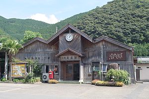
 Facade of Tosa-Taishō Station in 2007 | |||||||||||
| General information | |||||||||||
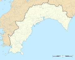
| Location | Taishō, Shimanto-chō, Takaoka-gun, Kōchi-ken 786-0301 Japan | ||||||||||
| Coordinates | 33°11′41″N 132°58′33″E / 33.1948°N 132.9758°E | ||||||||||
| Operated by | |||||||||||
| Line(s) | ■ Yodo Line | ||||||||||
| Distance | 17.6 km from Wakai | ||||||||||
| Platforms | 1 island platform | ||||||||||
| Tracks | 2 | ||||||||||
| Connections | Bus stop | ||||||||||
| Construction | |||||||||||
| Parking | Available | ||||||||||
| Bicycle facilities | No bike shed | ||||||||||
| Accessible | No - steps lead up to platform | ||||||||||
| Other information | |||||||||||
| Status | Staffed (Kan'i itaku station) | ||||||||||
| Station code | G30 | ||||||||||
| History | |||||||||||
| Opened | 1 March 1974 | ||||||||||
| Passengers | |||||||||||
| FY2018 | 30 | ||||||||||
| Services | |||||||||||
| |||||||||||
| |||||||||||
Tosa-Taishō Station (土佐大正駅, Tosa-Taishō-eki) is a passenger railway station located in the town of Shimanto, Takaoka District, Kōchi, Japan. It is operated by Shikoku Railway Company (JR Shikoku). The station bears the number "G30".[1][2]
Lines
[edit]The station is served by JR Shikoku's Yodo Line and is 17.6 kilometers from the starting point of then line at Wakai.[3]
Layout
[edit]The station building is built of timber in the style of a mountain lodge. There is a ticket window, waiting area and a shop. A tunnel and a flight of steps lead from the station to an island platform serving two tracks. Parking is available on a paved compound beside the track. A bus company maintains an office in the station premises and there is a bus depot next to the building.[1][4]
History
[edit]The station opened on 1 March 1974 under the control of Japanese National Railways. After the privatization of JNR on 1 April 1987, control of the station passed to JR Shikoku.[5]
Surrounding area
[edit]- The station is located in the centre of the former town of Taishō which was merged into the town of Shimanto in 2006.
- Shimanto River - runs next to Taisho near the station.
- National Route 381 - runs through Taisho between the station and the river.
- Old Takeuchi Family Residence - half a kilometer from the station. It is an example of a traditional mountain village farmhouse of thatch and timber construction which has been listed as an Important Cultural Property.[6]
- Mutemuka Brewery (無手無冠) - a sake brewery which also produces a shōchū made from chestnuts.[7]
- Todoroki Park (轟公園) - a local recreation area with a windmill made of stone.[8]
- River Park Todoroki (轟公園) - a campsite by the Shimanto River.[9]
- Shimanto Taishō Road Station - a service station along National Route 381.[10]
See also
[edit]References
[edit]- ^ a b "土佐大正" [Tosa-Taishō]. yodosen-green.com. Retrieved 26 November 2017.
- ^ "Shikoku Railway Route Map" (PDF). JR Shikoku. Retrieved 25 November 2017.
- ^ "Tosa-Taishō Station Timetable" (PDF). JR Shikoku. Retrieved 26 November 2017.
- ^ "土佐大正(とさたいしょう)駅" [Tosa-Taishō Station]. Retrieved 26 November 2017.
- ^ Ishino, Tetsu; et al., eds. (1998). 停車場変遷大事典 国鉄・JR編 [Station Transition Directory – JNR/JR] (in Japanese). Vol. II. Tokyo: JTB Corporation. p. 647. ISBN 4-533-02980-9.
- ^ "旧竹内家" [Old Takeuchi House]. attaka.or.jp. Retrieved 26 November 2017.
- ^ "株式会社 無手無冠" [Mutemuka Company]. mutemuka.com. Retrieved 1 December 2017.
- ^ "轟公園" [Todoroki Park]. attaka.or.jp. Retrieved 1 December 2017.
- ^ "リバーパーク轟" [River Park Todoroki]. attaka.or.jp. Retrieved 1 December 2017.
- ^ "道の駅 四万十大正" [Road Station Shimanto Taishō]. attaka.or.jp. Retrieved 1 December 2017.
External links
[edit]![]() Media related to Tosa-Taishō Station at Wikimedia Commons
Media related to Tosa-Taishō Station at Wikimedia Commons


