Thai–Laotian Border War
| Thai–Lao Border War Battle of Ban Romklao | |||||||||
|---|---|---|---|---|---|---|---|---|---|
| Part of the Third Indochina War that was part of the Cold War | |||||||||
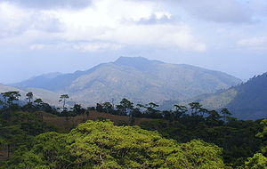
 เนิน 1428 (Hill 1428), the battlefield of Thai–Lao Border War of 1988, view from Phu Soidao National Park, Chat Trakan, Phitsanulok. | |||||||||
| |||||||||
| Belligerents | |||||||||
|
Supported by: |
| ||||||||
| Commanders and leaders | |||||||||
|
|
| ||||||||
| Casualties and losses | |||||||||
|
2 soldiers killed 2 soldiers killed |
147 soldiers were killed, 166 soldiers were injured. [1][2] 2 aircraft (February)[3] | ||||||||
The Thai–Lao Border War, or known in Thai as Battle of Ban Romklao (Thai: สมรภูมิบ้านร่มเกล้า or ยุทธการบ้านร่มเกล้า; December 1987 – February 1988), was a short confrontation between Thai and Lao forces. It involved a dispute over the map made by French surveyors in 1907 to mark the borders between Siam and French Indochina in the southern Luang Prabang Range. Ownership of the village of Ban Romklao on the border of Phitsanulok Province and three small border villages on the edge of Uttaradit Province was left unclear. This is the same map underlying the Cambodian–Thai border dispute. The agreed criterion for determining ownership was the natural watershed, but the French map makers at times ignored this.[4] As the agreed-upon river Hoeng separated into two tributaries, both parties claimed different ones as the border, which, alongside logging disputes, gave rise to this conflict.[3]
Battle
[edit]A series of minor shooting incidents had occurred between Thai and Lao forces in 1984. In December 1987, however, Thai armed forces occupied the disputed village of Ban Romklao, raising the Thai flag over it. The government of the Lao People's Democratic Republic protested strongly, insisting the village was part of Botene District of Saiyabuli Province. Thailand replied that the village belonged to Chat Trakan District (amphoe) of Phitsanulok Province. Lao Army forces staged a night attack on the small Thai garrison, driving the Thai soldiers from the village and replacing the Thai flag with that of Laos. Serious fighting followed, continuing for weeks until a cease-fire was declared on 19 February 1988.
On 15 December 1987, Thai F-5 planes bombed Lao positions in the region and Lao officials claimed Thailand shelled up to 10 km into Sayaboury province. Frequent aerial attacks continued against the dug-in Lao alongside artillery exchanges, and by mid-January 1988 the Thai claimed to have secured 70% of ground around Hill 1428. The fighting continued in February as the Lao still retained strategic high ground, with Thai airstrikes losing 2 aircraft. Talks eventually occurred on the 16-17th, and a ceasefire on the 19th saw both sides retreat 3 km from the line of contact.[3]
Summary of the battle
Throughout the conflict on the Rom Klao battlefield 150-200 Thai soldiers died and 400 were injured, while the Third Army Region reported a different number of casualties: 167 seriously injured, 550 slightly injured, and 55 disabled. Thailand spent about 3,000 million baht on the Romklao Battlefield.
While the number of losses in Laos is unclear. But it is estimated that about 50-100 Laotian soldiers were killed, about 100-200 injured, and it is believed that there were also foreign soldiers from the Soviet Union, Vietnam, and Cuba included. The Thai side believed that the Lao side had foreign soldiers to help fight and support. But the Laos side denies this.
Aftermath
[edit]The Thai-Lao Joint Boundary Commission (JBC) was established in 1996 to clarify the 1,810-kilometre boundary and settle ownership of the disputed villages. As of 2007[update] border demarcation was ongoing.[4]
References
[edit]- ^ "The History Guy: Thailand-Laos Border War 1987-1988".
- ^ Clodfelter, Micheal (2017). Warfare and Armed Conflicts: A Statistical Encyclopedia of Casualty and Other Figures, 1492-2015 (4th ed.). McFarland. p. 627. ISBN 9781476625850.Jefferson, North Carolina: McFarland. ISBN 978-0786474707
- ^ a b c "Major World Events - February 1988" (PDF). Stanford University. Archived from the original (PDF) on November 21, 2022.
- ^ a b Supalak Ganjanakhundee (March 8, 2007). "Lao border talks progressing". The Nation. Archived from the original on October 5, 2012. Retrieved February 8, 2011.
Officials from both sides will start to conduct aerial photography for mapping this month before beginning the demarcation process and plan to complete the task by 2010.
- 1987 in Laos
- 1987 in Thailand
- 1988 in Laos
- 1988 in Thailand
- Conflicts in 1987
- Conflicts in 1988
- Indochina Wars
- Laos–Thailand border
- Territorial disputes of Laos
- Territorial disputes of Thailand
- Third Indochina War
- Wars involving Laos
- Wars involving Thailand
- Wars involving Vietnam
- Proxy wars
- Anti-Thai sentiment
- Sainyabuli province
