Taybad County
Appearance
Taybad County
Persian: شهرستان تایباد | |
|---|---|
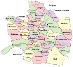
 Location of Taybad County in Razavi Khorasan province (bottom right, green) | |
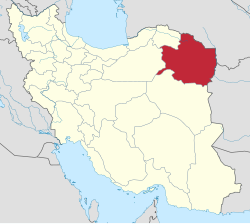
 Location of Razavi Khorasan province in Iran | |
| Coordinates: 34°45′N 60°40′E / 34.750°N 60.667°E[1] | |
| Country | |
| Province | Razavi Khorasan |
| Capital | Taybad |
| Districts | Central, Miyan Velayat |
| Area | |
• Total | 2,929 km2 (1,131 sq mi) |
| Elevation | 810 m (2,660 ft) |
| Population (2016)[2] | |
• Total | 117,564 |
| • Density | 40/km2 (100/sq mi) |
| Time zone | UTC+3:30 (IRST) |
Taybad County (Persian: شهرستان تایباد) is in Razavi Khorasan province, Iran. Its capital is the city of Taybad.[3]
History
[edit]After the 2006 National Census, Bakharz District was separated from the county in the establishment of Bakharz County.[4]
Demographics
[edit]Population
[edit]At the time of the 2006 census, the county's population was 143,205, in 31,291 households.[5] The following census in 2011 counted 108,424 people in 26,673 households.[6] The 2016 census measured the population of the county as 117,564 in 30,718 households.[2]
Administrative divisions
[edit]Taybad County's population history and administrative structure over three consecutive censuses are shown in the following table.
| Administrative Divisions | 2006[5] | 2011[6] | 2016[2] |
|---|---|---|---|
| Central District | 75,893 | 85,468 | 92,205 |
| Karat RD | 14,411 | 16,922 | 17,955 |
| Pain Velayat RD | 5,689 | 5,875 | 6,586 |
| Kariz (city) | 9,565 | 10,391 | 11,102 |
| Taybad (city) | 46,228 | 52,280 | 56,562 |
| Bakharz District[a] | 40,076 | ||
| Bakharz RD[b] | 16,077 | ||
| Bala Velayat RD | 17,145 | ||
| Bakharz (city) | 6,854 | ||
| Miyan Velayat District | 27,236 | 22,956 | 25,357 |
| Dasht-e Taybad RD[c] | 11,315 | 8,480 | 9,491 |
| Kuhsangi RD | 7,614 | 5,265 | 5,761 |
| Mashhad Rizeh (city) | 8,307 | 9,211 | 10,105 |
| Total | 143,205 | 108,424 | 117,564 |
| RD = Rural District | |||
See also
[edit]![]() Media related to Taybad County at Wikimedia Commons
Media related to Taybad County at Wikimedia Commons
Notes
[edit]- ^ Transferred to Bakharz County[4]
- ^ Renamed Malin Rural District
- ^ Formerly Miyan Velayat Rural District
References
[edit]- ^ OpenStreetMap contributors (4 November 2024). "Taybad County" (Map). OpenStreetMap (in Persian). Retrieved 4 November 2024.
- ^ a b c Census of the Islamic Republic of Iran, 1395 (2016): Razavi Khorasan Province. amar.org.ir (Report) (in Persian). The Statistical Center of Iran. Archived from the original (Excel) on 2 April 2022. Retrieved 19 December 2022.
- ^ Habibi, Hassan (c. 2015) [Approved 21 June 1369]. Approval of the organization and chain of citizenship of the elements and units of the divisions of Khorasan province, centered in Mashhad. rc.majlis.ir (Report) (in Persian). Ministry of the Interior, Defense Political Commission of the Government Council. Proposal 3223.1.5.53; Approval Letter 3808-907; Notification 84902/T125K. Archived from the original on 17 November 2015. Retrieved 6 January 2024 – via Islamic Parliament Research Center.
- ^ a b Rahimi, Mohammad Reza (14 August 2019) [Approved 5 March 1389]. Letter of approval regarding divisional reforms in Razavi Khorasan province. rc.majlis.ir (Report) (in Persian). Ministry of the Interior, Board of Ministers. Proposal 203213/42/1/4/1; Notification 105111/T44362. Archived from the original on 5 November 2010. Retrieved 5 January 2024 – via Islamic Parliament Research Center.
- ^ a b Census of the Islamic Republic of Iran, 1385 (2006): Razavi Khorasan Province. amar.org.ir (Report) (in Persian). The Statistical Center of Iran. Archived from the original (Excel) on 20 September 2011. Retrieved 25 September 2022.
- ^ a b Census of the Islamic Republic of Iran, 1390 (2011): Razavi Khorasan Province. irandataportal.syr.edu (Report) (in Persian). The Statistical Center of Iran. Archived from the original (Excel) on 20 January 2023. Retrieved 19 December 2022 – via Iran Data Portal, Syracuse University.

