Tanghekou
Tanghekou Town
汤河口镇 | |
|---|---|
 Sight near Dazhazi Village, northwest of the town, 2012 | |
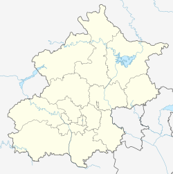
 Location of Tanghekou Town within Huairou District | |
| Coordinates: 40°44′09″N 116°38′21″E / 40.73583°N 116.63917°E | |
| Country | China |
| Municipality | Beijing |
| District | Huairou |
| Village-level Divisions | 1 community 22 villages |
| Area | |
• Total | 224.6 km2 (86.7 sq mi) |
| Elevation | 290 m (950 ft) |
| Population (2020) | |
• Total | 5,445 |
| • Density | 24/km2 (63/sq mi) |
| Time zone | UTC+8 (China Standard) |
| Postal code | 101400 |
| Area code | 010 |
Tanghekou Town (simplified Chinese: 汤河口镇; traditional Chinese: 湯河口鎮; pinyin: Tānghékǒu Zhèn), is a town in the northern side of Huairou District, Beijing, China. It shares border with Labagoumen and Changshaoying Manchu Ethnic Townships to the northeast, Shicheng and Liulimiao Towns to the south, and Baoshan Town to the southwest. In 2020 it had a total population of 5,445.[1] Its name Tanghekou literally means "North House".
The town is situated inside a river valley, around the confluence of Bai River and Tang River. For this reason it receives its name Tanghekou (Chinese: 汤河口; lit. 'Mouth of Tang River').[2]
History
[edit]| Time | Status | Under |
|---|---|---|
| 1949 - 1951 | 6th District | Sihai County, Chahar |
| 1951 - 1952 | 12th District | Luanping County, Chahar |
| 1952 - 1956 | 6th District | Huairou County, Hebei |
| 1956 - 1958 | Tanghekou Township | |
| 1958 - 1959 | Gangtie People's Commune | Huairou County, Beijing |
| 1959 - 1960 | Tanghekou People's Commune
Changshaoying People's Commune | |
| 1960 - 1961 | Qingshiling People's Commune | |
| 1961 - 1983 | Tanghekou People's Commune | |
| 1983 - 1990 | Tanghekou Township | |
| 1990 - 2001 | Tanghekou Town | |
| 2001–present | Huairou District, Beijing |
Administrative divisions
[edit]As of the time in writing, there are 23 subdivisions within Tanghekou Town, where 1 of them is a community and all the rest are villages:[3]
| Subdisvision Names | Name Transliterations | Type |
|---|---|---|
| 汤河口 | Tanghekou | Community |
| 小梁前 | Xiaoliangqian | Village |
| 二号沟门 | Erhao Goumen | Village |
| 黄花甸子 | Huanghua Dianzi | Village |
| 许营 | Xuying | Village |
| 银河沟 | Yinghegou | Village |
| 大栅子 | Dazhazi | Village |
| 庄户沟门 | Zhuanghu Goumen | Village |
| 东帽湾 | Dong Maowan | Village |
| 西帽湾 | Xi Maowan | Village |
| 大榆树 | Dayushu | Village |
| 新地 | Xindi | Village |
| 汤河口 | Tanghekou | Village |
| 河东 | Hedong | Village |
| 大蒲池沟 | Dapu Digou | Village |
| 连石沟 | Lianshigou | Village |
| 古石沟门 | Gu Shigoumen | Village |
| 东黄梁 | Dong Huangliang | Village |
| 卜营 | Buying | Village |
| 大黄塘 | Da Huangtang | Village |
| 小黄塘 | Xiao Huangtang | Village |
| 后安岭 | Hou'anling | Village |
| 东湾子 | Dongwanzi | Village |
Climate
[edit]| Climate data for Tanghekou Town, elevation 332 m (1,089 ft), (1991–2020 normals) | |||||||||||||
|---|---|---|---|---|---|---|---|---|---|---|---|---|---|
| Month | Jan | Feb | Mar | Apr | May | Jun | Jul | Aug | Sep | Oct | Nov | Dec | Year |
| Mean daily maximum °C (°F) | 0.8 (33.4) |
5.1 (41.2) |
12.0 (53.6) |
20.1 (68.2) |
26.4 (79.5) |
29.8 (85.6) |
30.8 (87.4) |
29.9 (85.8) |
25.5 (77.9) |
18.6 (65.5) |
9.1 (48.4) |
1.8 (35.2) |
17.5 (63.5) |
| Daily mean °C (°F) | −8.5 (16.7) |
−4.3 (24.3) |
3.4 (38.1) |
11.8 (53.2) |
18.0 (64.4) |
22.2 (72.0) |
24.3 (75.7) |
22.9 (73.2) |
17.2 (63.0) |
9.7 (49.5) |
0.5 (32.9) |
−7.0 (19.4) |
9.2 (48.5) |
| Mean daily minimum °C (°F) | −15.5 (4.1) |
−11.8 (10.8) |
−4.5 (23.9) |
3.6 (38.5) |
9.5 (49.1) |
15.3 (59.5) |
19.0 (66.2) |
17.6 (63.7) |
11.0 (51.8) |
2.9 (37.2) |
−5.7 (21.7) |
−13.3 (8.1) |
2.3 (36.2) |
| Average precipitation mm (inches) | 1.3 (0.05) |
3.7 (0.15) |
8.8 (0.35) |
19.3 (0.76) |
41.1 (1.62) |
74.1 (2.92) |
133.2 (5.24) |
88.6 (3.49) |
54.4 (2.14) |
25.9 (1.02) |
10.8 (0.43) |
1.9 (0.07) |
463.1 (18.24) |
| Average precipitation days (≥ 0.1 mm) | 1.3 | 1.9 | 2.9 | 4.4 | 7.9 | 11.8 | 13.5 | 10.9 | 8.6 | 5.1 | 2.8 | 1.8 | 72.9 |
| Average snowy days | 2.1 | 2.2 | 2.0 | 0.3 | 0 | 0 | 0 | 0 | 0 | 0.1 | 2.1 | 2.0 | 10.8 |
| Average relative humidity (%) | 50 | 45 | 42 | 43 | 51 | 63 | 75 | 77 | 73 | 63 | 57 | 54 | 58 |
| Mean monthly sunshine hours | 205.3 | 201.0 | 238.3 | 251.2 | 270.6 | 236.7 | 214.6 | 228.1 | 224.4 | 215.1 | 188.4 | 195.5 | 2,669.2 |
| Percent possible sunshine | 69 | 66 | 64 | 63 | 60 | 53 | 47 | 54 | 61 | 63 | 64 | 68 | 61 |
| Source: China Meteorological Administration[4][5] | |||||||||||||
Gallery
[edit]-
Checkpoint in Tanghekou, 2012
-
Entrance of Yinghegu Walnut Farm, 2012
-
Pillars along Zhuangla Road, with the inscroption of "人寿年丰“ (Long Life and Bountiful Harvest). 2012
-
Entrance of Xiaoliangqian Village, 2012
See also
[edit]References
[edit]- ^ "北京市怀柔区第七次全国人口普查公报_重点工作_怀柔区人民政府网站". www.bjhr.gov.cn. Retrieved 2022-10-24.
- ^ a b 李立国; 李万钧; 吴世民, eds. (2013). 中华人民共和国政区大典, 北京市卷. Beijing: 中国社会出版社. ISBN 978-7-5087-4058-4. OCLC 910451741.
- ^ "2021年统计用区划代码和城乡划分代码". www.stats.gov.cn. Retrieved 2022-10-26.
- ^ 中国气象数据网 – WeatherBk Data (in Simplified Chinese). China Meteorological Administration. Retrieved 10 October 2023.
- ^ 中国气象数据网 (in Simplified Chinese). China Meteorological Administration. Retrieved 10 October 2023.


