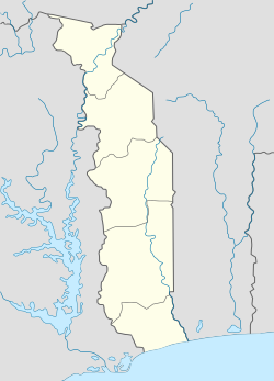
Tététou
Tététou | |
|---|---|
| Coordinates: 7°01′00″N 1°30′00″E / 7.01667°N 1.5°E | |
| Country | Togo |
Tététou is a Togolese municipality located in the Haho Prefecture, in the Plateaux Region, southeastern Togo. The municipality is situated in the center of the protected forest of Tététou.
Hydrography[edit]
The municipality is situated on the Mono River, one of the major rivers of the country.[1][2] It is located downstream of the Nangbeto Dam.[3][4]
History[edit]
Pre-colonial situation[edit]
This section is empty. You can help by adding to it. (July 2024) |
Colonization[edit]
During the colonial period under German and French rule, the region where the municipality is located experienced significant demographic changes.[5] German forces temporarily occupied Tététou during World War I before being ousted from the area.[6]
In the 1920s, the region was colonized by the Kabye people with the approval of European colonial authorities, who saw it as a way to settle labor in a relatively sparsely populated area.[5] The municipality produced cotton, which was collected by French colonists and transported via a railway to Notsé.[7] From there, it was directed to colony ports for export to metropolitan France.[7]
Post-colonial Togo[edit]
After the construction of the Nangbeto Dam, the municipality faced challenges related to its reservoir filling, but these issues diminished over time.[8] The commune also had strong ties with neighboring Benin until it became more connected to the rest of Togo.[9] In the early 21st century, tensions arose due to land acquisitions by large landowners from urban areas, creating friction among various peoples in the region, particularly between the Ewe and Aja communities.[10]
Togo established a classified forest named Tététou forest.[11][12] To address regional energy needs, in 2019-2020, construction began on a hydroelectric power plant in the area,[13][14][15] intended to have a capacity of 24MW upon completion.[16]
References[edit]
- ^ Programme de lutte contre l'onchocercose en Afrique de l'Ouest (PDF) (in French). Bouaké: ONCHOCERCIASIS CONTROL PROGRAMME. 1987.
- ^ Tsogbe, Yawo Dodzi (November 2014). "Impacts des changements climatiques sur le bilan hydrique des cultures au Togo". archipel.uqam.ca (in French). Mohamed Berraja. Retrieved 2024-07-07.
- ^ Amoussou, Ernest (2014-09-15), Analyse hydrométéorologique des crues dans le bassin-versant du Mono en Afrique de l'Ouest avec un modèle conceptuel pluie-débit (in French), archived from the original on 2023-11-14, retrieved 2024-07-07
- ^ Djan’na Koubodana, H.; Adounkpe, Julien G.; Atchonouglo, Kossi; Djaman, Koffi; Larbi, Isaac; Lombo, Yao; Kpemoua, Kossi E. (2023-04-03). "Modelling of streamflow before and after dam construction in the Mono River Basin in Togo-Benin, West Africa". International Journal of River Basin Management. 21 (2): 265–281. doi:10.1080/15715124.2021.1969943. ISSN 1571-5124. Archived from the original on 2022-06-20. Retrieved 2024-07-07.
- ^ a b Atta, Koffi; Zoungrana, Tanga (2010). Logiques paysannes et espaces agraires en Afrique. Maîtrise de l'espace et développement. Paris: Éd. Karthala. ISBN 978-2-8111-0369-9.
- ^ Marguerat, Yves (2006), Tirefort, Alain (ed.), "La guerre d'août 1914 au Togo : Histoire militaire et politique d'un épisode décisif pour l'identité nationale togolaise", Guerres et paix en Afrique noire et à Madagascar : xixe et xxe siècles, Enquêtes et documents (in French), Rennes: Presses universitaires de Rennes, pp. 95–143, ISBN 978-2-7535-4927-2, archived from the original on 2024-02-20, retrieved 2024-07-07
- ^ a b "Ouvrages de référence — Wikipédia". fr.wiki.x.io (in French). Retrieved 2024-07-07.
- ^ Antoine, Philippe; Rossi, Georges (1990). "Les conséquences de la construction d'un grand barrage : l'exemple de Nangbéto (Togo-Bénin)". Espaces Tropicaux. 2 (1): 3–19.
- ^ "Ouvrages de référence — Wikipédia". fr.wiki.x.io (in French). Retrieved 2024-07-07.
- ^ Klassou, Selom K. (2002-03-30). "Croyances coutumières, pratiques foncières et développement rural au Togo. Cas des préfectures de Haho et du Moyen-Mono". Belgeo. Revue belge de géographie (in French) (1): 29–44. doi:10.4000/belgeo.15437. ISSN 1377-2368. Archived from the original on 2023-03-06. Retrieved 2024-07-07.
- ^ Almoradie, Adrian Delos Santos; Houngue, Nina Rholan; Komi, Kossi; Adounkpe, Julien; Evers, Mariele (January 2023). "Transboundary Collaborative Modeling: Consensual Identification and Ranking of Flood Adaptation Measures—A Case Study in the Mono River Basin, Benin, and Togo". Sustainability. 15 (15): 11728. doi:10.3390/su151511728. ISSN 2071-1050.
- ^ Akodéwou, Amah; Godron, Michel (February 2022). "Agricultural Land-Use Increases Floral Species Richness in Tropical Dry Forest and Savannah Ecosystems in West Africa". Diversity. 14 (2): 106. doi:10.3390/d14020106. ISSN 1424-2818.
- ^ "EOIs sought from EPC contractors to build Tététou in Togo | Hydropower & Dams International". www.hydropower-dams.com. Archived from the original on 2024-03-01. Retrieved 2024-07-07.
- ^ "Energie électrique: Aménagement du site de Tététou - Togo Breaking News" (in French). 2020-05-23. Archived from the original on 2021-10-24. Retrieved 2024-07-07.
- ^ "EPC contractor sought for Tététou in Togo | Hydropower & Dams International". www.hydropower-dams.com. Archived from the original on 2023-10-01. Retrieved 2024-07-07.
- ^ First, Togo. "Togo : un barrage multifonction à 78 milliards FCFA annoncé à Sarakawa". www.togofirst.com (in French). Archived from the original on 2023-05-13. Retrieved 2024-07-07.

