City of St Albans
City and District of St Albans | |
|---|---|
| St Albans | |
 | |
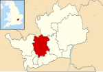
 St Albans shown within Hertfordshire | |
| Sovereign state | United Kingdom |
| Country | England |
| Region | East of England |
| Non-metropolitan county | Hertfordshire |
| Status | Non-metropolitan district, Borough & City |
| Admin HQ | St Albans |
| Incorporated | 1 April 1974 |
| Government | |
| • Type | Non-metropolitan district council |
| • Body | St Albans City and District Council |
| • Leadership | Leader & Committee Structure |
| • MPs | Daisy Cooper (LD) Victoria Collins (LD) |
| Area | |
• Total | 62.23 sq mi (161.18 km2) |
| • Rank | 177 (of 296) |
| Population (2022) | |
• Total | 147,095[1] |
| • Rank | 141 (of 296) |
| Ethnicity (2021) | |
| • Ethnic groups | |
| Religion (2021) | |
| • Religion | List
|
| Time zone | UTC0 (GMT) |
| • Summer (DST) | UTC+1 (BST) |
| ONS code | 26UG (ONS) E07000100 (GSS) |
| OS grid reference | TL148073 |
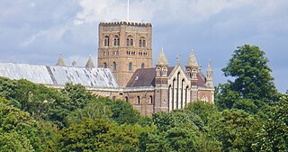
St Albans (/ˈɔːlbənz/),[3] also known as the City and District of St Albans, is a local government district with city status in Hertfordshire, England. Its council is based in St Albans, the largest settlement in the district. The district also includes the town of Harpenden and several villages. The district borders North Hertfordshire, Welwyn Hatfield, Hertsmere, Watford, Three Rivers, Dacorum, and Central Bedfordshire.
History
[edit]The town of St Albans had been an ancient borough since 1553. It was reformed in 1836 to become a municipal borough and additionally gained city status in 1877.[4][5]
The modern St Albans district was created on 1 April 1974 under the Local Government Act 1972, covering the area of three former districts, which were all abolished at the same time:[6]
- Harpenden Urban District
- St Albans Municipal Borough
- St Albans Rural District (except the part within the designated area of Hemel Hempstead New Town, which went to Dacorum.)
The new district was named St Albans after its largest settlement.[7] It was awarded borough status from its creation, allowing the chair of the council to take the title of mayor, continuing the series of mayors of St Albans which had started in 1553.[8] The city status which had been held by the old municipal borough of St Albans was extended to cover the whole of the new district on 9 July 1974.[9] As such the council could call itself "St Albans City Council", which name is sometimes used for it in official documents,[10] but chooses to style itself "St Albans City and District Council" instead.[11]
Geography
[edit]The largest settlement is St Albans, followed in size by Harpenden, with the main villages being Redbourn, Wheathampstead, London Colney, Chiswell Green and Bricket Wood.
Nearby towns include Hatfield and Welwyn Garden City to the east, Luton and Dunstable to the north, Hemel Hempstead to the west, Watford to the southwest and Borehamwood to the south. The district lies close to Greater London, at the closest point being less than 4 miles (6.4 km) from its outer boundary. From the centre of St Albans to the centre of London is about 19 miles (31 km).
Governance
[edit]St Albans City and District Council | |
|---|---|
| Type | |
| Type | |
| Leadership | |
Amanda Foley since 17 July 2017[14] | |
| Structure | |
| Seats | 56 |
Political groups |
|
| Elections | |
Last election | 2 May 2024 |
Next election | 7 May 2026 |
| Meeting place | |
 | |
| Civic Centre, St Peter's Street, St Albans, AL1 3JE | |
| Website | |
| www | |
Hertfordshire has a two-tier structure of local government, with the ten district councils (including St Albans City and District Council) providing district-level services, and Hertfordshire County Council providing county-level services. In some areas there is an additional third tier of civil parishes.[15]
Hertfordshire County Council is responsible for services including education, transport, fire and public safety, social care and libraries. The district council's responsibilities include electoral services, food safety, licensing, car parks, allotments, cemeteries, grounds maintenance, leisure and theatre facilities (in Council's ownership) museums, parks and open spaces, markets, street cleaning, management and maintenance of council owned housing, the administration of housing benefits, town planning, and building control.[11] Parish council responsibilities include allotments, youth projects, leisure facilities, open spaces, traffic calming and community transport schemes.[11]
Political control
[edit]The first elections to the district council were held in 1973, initially acting as a shadow authority alongside the outgoing authorities until the new arrangements took effect on 1 April 1974. Political control since 1974 has been as follows:[16]
| Party in control | Years | |
|---|---|---|
| Conservative | 1974–1984 | |
| No overall control | 1984–1988 | |
| Conservative | 1988–1991 | |
| No overall control | 1991–1994 | |
| Liberal Democrats | 1994–1999 | |
| No overall control | 1999–2006 | |
| Liberal Democrats | 2006–2007 | |
| No overall control | 2007–2008 | |
| Liberal Democrats | 2008–2011 | |
| No overall control | 2011–2015 | |
| Conservative | 2015–2019 | |
| No overall control | 2019–2021 | |
| Liberal Democrats | 2021–present | |
Leadership
[edit]The role of mayor of St Albans is largely ceremonial. They preside at council meetings and act as first citizen of the district. They are chosen from among the councillors but are expected to maintain a non-political stance, although they do have the right to exercise a casting vote in the case of a tied vote at a meeting. The role of mayor is usually held by a different councillor each year, continuing the series of mayors of St Albans which dates back to the first borough charter of 1553.[17]
Political leadership is instead provided by the leader of the council. The leaders since 2004 have been:[18]
| Councillor | Party | From | To | |
|---|---|---|---|---|
| Robert Donald | Liberal Democrats | 23 Jun 2004 | 18 May 2011 | |
| Julian Daly | Conservative | 18 May 2011 | 24 May 2017 | |
| Alec Campbell | Conservative | 24 May 2017 | 5 May 2019 | |
| Chris White | Liberal Democrats | 22 May 2019 | 5 May 2024 | |
| Paul De Kort | Liberal Democrats | 22 May 2024 | ||
Composition
[edit]Following the 2024 election the composition of the council was:[19]
| Party | Councillors | |
|---|---|---|
| Liberal Democrats | 47 | |
| Conservative | 3 | |
| Green | 3 | |
| Labour | 2 | |
| Independent | 1 | |
| Total | 56 | |
The next election is due in May 2026.
Premises
[edit]The council is based at the Civic Centre on St Peter's Street in the centre of St Albans. The building was purpose-built for the council in 1989[20] and incorporates an emergency bunker in the basement, now used as committee rooms.[21]
Elections
[edit]Since the last boundary changes in 2022 the council has comprised 56 councillors, with the district being divided into 20 wards, each electing one, two or three councillors. Elections are held three years out of every four, electing roughly a third of the council each time. Elections to Hertfordshire County Council are held in the fourth year of the cycle when there are no district council elections.[22]
Wards
[edit]The district's wards are:[22]
- Batchwood
- Bernards Heath
- Clarence
- Colney Heath
- Cunningham
- Harpenden East
- Harpenden North and Rural
- Harpenden South
- Harpenden West
- Hill End
- London Colney
- Marshalswick East and Jersey Farm
- Marshalswick West
- Park Street
- Redbourn
- Sandridge and Wheathampstead
- Sopwell
- St Peters
- St Stephen
- Verulam
Parishes
[edit]There are parish councils in Colney Heath, Harpenden, Harpenden Rural, London Colney, Redbourn, St Michael, St Stephen (including the villages of Chiswell Green and Bricket Wood), Sandridge and Wheathampstead. Harpenden's parish council takes the style "town council". The area of the pre-1974 borough of St Albans is an unparished area, where local affairs are discussed by a City Neighbourhoods Committee comprising the district councillors for that area.[23]
| Parish | Council | Population (2011) | Area (2011) |
|---|---|---|---|
| Colney Heath | Colney Heath Parish Council | 5,962 | 1,119 hectares (4.32 sq mi) |
| Harpenden | Harpenden Town Council | 29,448 | 1,278 hectares (4.93 sq mi) |
| Harpenden Rural | Harpenden Rural Parish Council | 405 | 923 hectares (3.56 sq mi) |
| London Colney | London Colney Parish Council | 9,507 | 513 hectares (1.98 sq mi) |
| Redbourn | Redbourn Parish Council | 5,344 | 1,908 hectares (7.37 sq mi) |
| Sandridge | Sandridge Parish Council | 11,451 | 1,518 hectares (5.86 sq mi) |
| St Michael | St Michael Parish Council | 477 | 2,120 hectares (8.2 sq mi) |
| St Stephen | St Stephen Parish Council | 13,865 | 2,329 hectares (8.99 sq mi) |
| Wheathampstead | Wheathampstead Parish Council | 6,410 | 2,599 hectares (10.03 sq mi) |
| Total parishes | 82,869 | 14,307 hectares (55.24 sq mi) | |
| St Albans (unparished) | City Neighbourhood Committee | 57,795 | 1,811 hectares (6.99 sq mi) |
| St Albans City and District | St Albans City and District Council | 140,664 | 16,118 hectares (62.23 sq mi) |
Economy
[edit]St Albans has a highly skilled workforce, with the 4th highest proportion of managers, senior officials and professional occupations in the country. Nearly half of working age residents have a degree or equivalent qualification. Average weekly earnings are £724.40, 44% higher than the national average.[24][when?] The St Albans District has lower than average unemployment and the lowest in Hertfordshire.[24] 2.8% of residents are disabled or permanently sick, compared with 5–6% nationally.[24]
Deloitte, Spreadex, AECOM, PricewaterhouseCoopers and Premier Foods have offices in the district. Sainsbury's Retail Distribution Centre at London Colney employs over 600 staff.[25]
In 2024 St Albans Market was awarded the title Best Large Outdoor Market by the National Association of British Market Authorities.[26]
Transport
[edit]The M1 motorway, the M25 motorway, the A414 road and A1081 road run through the district. The district has six railway stations. Two (St Albans City and Harpenden) are on the main Thameslink route from Bedford to Brighton via London. The other four are on the Abbey Line branch line from St Albans Abbey to Watford Junction.
Demography
[edit]In 2001 St Albans City and District had a population of 129,005 (50.8% female, 49.2% male). The mid 2012 population estimate was 138,800. By the time 2021 Census the population had risen to 148,167, with 75,167 females and 72,296 males.[27] In 2001 there were 20.5% children, 64.5% people of working age (16–64) and 14.9% older people (65+).[24] 86.9% of St Albans residents are White British, 4.3% Other White, 2% Irish and 1.3% Bangladeshi. 71% identify as Christian, 24.1% as "no religion" or "religion not stated", 2.6% as Muslim and 0.9% as Jewish.[24]
Twin towns
[edit]St Albans is twinned with:[28]
 Fano, Italy
 Nyíregyháza, Hungary
 Nevers, France
 Odense, Denmark
 Worms, Germany
 Nieuwleusen, Netherlands
 Sylhet, Bangladesh
In addition, there are friendship links with:
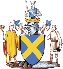
Arms
[edit]
|
|
See also
[edit]References
[edit]- ^ "Population estimates - Office for National Statistics". Archived from the original on 25 May 2017. Retrieved 29 June 2019.
- ^ a b UK Census (2021). "2021 Census Area Profile – St Albans Local Authority (E07000240)". Nomis. Office for National Statistics. Retrieved 5 January 2024.
- ^ "Local Authority Districts, Counties and Unitary Authorities (April 2021) Map in United Kingdom". Office for National Statistics: Open Geography Portal. Retrieved 1 August 2023.
- ^ Page, William (1908). A History of the County of Hertford, Volume 2. London: Victoria County History. pp. 477–483. Retrieved 30 January 2022.
- ^ "No. 24502". The London Gazette. 11 September 1877. p. 5185.
- ^ "The English Non-metropolitan Districts (Definition) Order 1972", legislation.gov.uk, The National Archives, SI 1972/2039, retrieved 12 May 2023
- ^ "The English Non-metropolitan Districts (Names) Order 1973", legislation.gov.uk, The National Archives, SI 1973/551, retrieved 12 May 2023
- ^ "District Councils and Boroughs". Parliamentary Debates (Hansard). 28 March 1974. Retrieved 13 May 2023.
- ^ "No. 46352". The London Gazette. 24 September 1974. p. 7920.
- ^ "The City of St Albans (Electoral Changes) Order 1998", legislation.gov.uk, The National Archives, SI 1998/2558, retrieved 13 May 2023
- ^ a b c "St Albans City and District Council". Retrieved 13 May 2023.
- ^ Wootton, Doug (23 May 2024). "Cllr Jamie Day elected as 480th new mayor of St Albans". Herts Advertiser. Retrieved 23 May 2024.
- ^ Mountney, Dan (23 May 2024). "St Albans City and District Council elects new leader". Herts Advertiser. Retrieved 23 May 2024.
- ^ "New chief executive confirmed". St Albans City and District Council. 14 July 2017. Retrieved 13 May 2023.
- ^ "Local Government Act 1972", legislation.gov.uk, The National Archives, 1972 c. 70, retrieved 3 March 2023
- ^ "Compositions calculator". The Elections Centre. 4 March 2016. Retrieved 22 September 2022.
- ^ "Mayoral Count" (PDF). stalbans.gov.uk. Archived (PDF) from the original on 9 March 2016. Retrieved 7 April 2018.
- ^ "Council minutes". St Albans City and District Council. Retrieved 8 June 2022.
- ^ "Local elections 2024: full mayoral and council results for England". The Guardian. 4 May 2024. Retrieved 21 May 2024.
- ^ "The Civic Centre" (PDF). St Albans Museums. Retrieved 21 May 2023.
- ^ Catford, Nick. "St Albans City and District Council Emergency Centre". Subterranea Britannica. Retrieved 13 May 2023.
- ^ a b "The St Albans (Electoral Changes) Order 2021", legislation.gov.uk, The National Archives, SI 2021/900, retrieved 13 May 2023
- ^ "Archived copy" (PDF). Archived (PDF) from the original on 3 December 2013. Retrieved 28 November 2013.
{{cite web}}: CS1 maint: archived copy as title (link) - ^ a b c d e "Mapped: St Albans Community Profile". Archived from the original on 29 June 2012. Retrieved 1 September 2012.
- ^ Mapped: St Albans Economy Report 2011
- ^ "Celebrating the UK's Best Markets as Great British Market Award Winners are Revealed". NABMA—the voice of markets. 24 January 2024. Archived from the original on 27 January 2024. Retrieved 27 January 2024.
- ^ Nomisweb Topic summary TS008
- ^ "St Albans City & District Council - Town twinning". Archived from the original on 31 October 2013. Retrieved 28 November 2013.
- ^ "East of England Region". Civic Heraldry of England. Retrieved 9 March 2021.


