South Avenue (Makati)
 The Manila South Cemetery on South Avenue | |
| Maintained by | Department of Public Works and Highways - Metro Manila 2nd District Engineering Office |
|---|---|
| Length | 805 m (2,641 ft)[1] |
| Location | Makati |
| North end | J.P. Rizal Avenue |
| Major junctions |
|
| South end | Metropolitan Avenue |
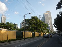
South Avenue is a short extension of Ayala Avenue north of Metropolitan Avenue in Makati, Metro Manila, Philippines. It forms the border between the Manila South Cemetery to the east and Barangay Santa Cruz to the west, running for 805 meters (2,641 ft) in a southwest–northeast direction from its southern terminus at Metropolitan Avenue to its intersection with J.P. Rizal Avenue in Barangay Olympia.[1] Since 2017, it has carried one-way northbound traffic to decongest traffic in and out of the Makati Central Business District.[2] It has a short extension into Barangay Olympia and Circuit Makati (formerly the Santa Ana Race Track) as Taliba Street.[3][4] It is also the location of the Ecoville Townhouses and F. Benitez Elementary School. It is formerly a component road of Circumferential Road 3.[5]
The avenue originated from an old road linking J.P. Rizal, Makati's main road, to the Manila South Cemetery and eventually to McKinley–Pasay Road near the Nielson Field (now occupied by the Makati Central Business District).[6][7][8] The origin of the avenue's name is unclear, but it may be derived from the cemetery it passes.
Intersections
[edit]The entire route is located in Makati.
| km | mi | Destinations | Notes | ||
|---|---|---|---|---|---|
| Metropolitan Avenue | Traffic light intersection; southern terminus. | ||||
| Pablo Ocampo Street (Vito Cruz Extension) | Traffic light intersection. | ||||
| Kalayaan Avenue | Traffic light intersection. One-way road. | ||||
| J.P. Rizal Avenue | Traffic light intersection; northern terminus. Continues to Circuit Makati as Taliba Street. | ||||
| 1.000 mi = 1.609 km; 1.000 km = 0.621 mi | |||||
See also
[edit]References
[edit]- ^ a b "Road and Bridge Inventory". Department of Public Works and Highways. Retrieved August 5, 2020.
- ^ Zurbano, Joel (June 22, 2017). "Makati changes CBD traffic route". Manila Standard. Retrieved May 15, 2020.
- ^ News - Makati Archived March 3, 2014, at the Wayback Machine published by MakeItMakati.com; accessed October 29, 2013.
- ^ Lowe, Aya (January 11, 2013). "Ayala transforms race track into Broadway, football hub". Rappler. Retrieved October 29, 2013.
- ^ "Latest alignment of all radial and circumferential roads in Metro Manila". Freedom of Information Philippines. Department of Public Works and Highways. Retrieved April 3, 2024.
- ^ "Vertical view of Nielson Field in Makati area of southern Manila". PacificWrecks. Retrieved September 21, 2021.
- ^ Manila City Plan (Map). 1943. Retrieved March 5, 2022.
- ^ Map of Manila and Suburbs (Map). 1:20,000. The Chief of Engineers, Washington, D.C. 1943. Retrieved March 5, 2022.
