Slavětín (Louny District)
Slavětín | |
|---|---|
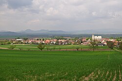
 Panorama of Slavětín with the Central Bohemian Uplands in the background | |
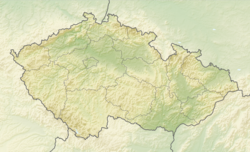
| Coordinates: 50°21′3″N 13°54′28″E / 50.35083°N 13.90778°E | |
| Country | |
| Region | Ústí nad Labem |
| District | Louny |
| First mentioned | 1269 |
| Area | |
• Total | 8.37 km2 (3.23 sq mi) |
| Elevation | 230 m (750 ft) |
| Population (2024-01-01)[1] | |
• Total | 653 |
| • Density | 78/km2 (200/sq mi) |
| Time zone | UTC+1 (CET) |
| • Summer (DST) | UTC+2 (CEST) |
| Postal codes | 439 09, 440 01 |
| Website | www |
Slavětín is a market town in Louny District in the Ústí nad Labem Region of the Czech Republic. It has about 700 inhabitants.
Administrative parts
[edit]The village of Kystra is an administrative part of Slavětín.
Etymology
[edit]The name is derived from the personal name Slavata, meaning "Slavata's (court)".[2]
Geography
[edit]Slavětín is located about 7 kilometres (4 mi) east of Louny and 44 km (27 mi) northwest of Prague. It lies in a mainly agricultural landscape in the Lower Ohře Table. The highest point is at 332 m (1,089 ft) above sea level. The northern municipal border is former by the Ohře River.
History
[edit]The first written mention of Slavětín is from 1269, when Prague bishop Jan III of Dražice received the settlement from King Ottokar II.[3]
Demographics
[edit]
|
|
| ||||||||||||||||||||||||||||||||||||||||||||||||||||||
| Source: Censuses[4][5] | ||||||||||||||||||||||||||||||||||||||||||||||||||||||||
Transport
[edit]Slavětín is located on the railway line Česká Lípa–Postoloprty.[6]
Sights
[edit]
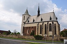
The main landmark of Slavětín is the Church of Saint James the Great. It is a rare medieval monument. It was built in the Romanesque style in the 13th century and rebuilt in the Gothic style in the 14th century. The original tower was replaced by the current one in 1837. In 1880–1881, the church was restored by Josef Mocker.[7]
A notable building is the octagonal Chapel of the Visitation of the Virgin Mary. It was built in the early Baroque style in 1672–1677.[8]
Notable people
[edit]- Konstantin Biebl (1898–1951), poet
- Otto Trefný (1932–2019), physician and politician
References
[edit]- ^ "Population of Municipalities – 1 January 2024". Czech Statistical Office. 2024-05-17.
- ^ Profous, Antonín (1957). Místní jména v Čechách IV: S–Ž (in Czech). pp. 97–98.
- ^ "Historie obce" (in Czech). Dobrovolný svazek obcí mikroregionu Perucko. Retrieved 2024-04-19.
- ^ "Historický lexikon obcí České republiky 1869–2011" (in Czech). Czech Statistical Office. 2015-12-21.
- ^ "Population Census 2021: Population by sex". Public Database. Czech Statistical Office. 2021-03-27.
- ^ "Detail stanice Slavětín n.Ohří" (in Czech). České dráhy. Retrieved 2024-04-19.
- ^ "Kostel sv. Jakuba Většího" (in Czech). National Heritage Institute. Retrieved 2024-04-19.
- ^ "Kaple Navštívení Panny Marie" (in Czech). National Heritage Institute. Retrieved 2024-04-19.


