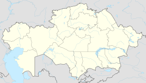
Sholakkorgan
Appearance
Sholakkorgan
Шолаққорған | |
|---|---|
Village | |
| Coordinates: 43°45′54″N 69°10′33″E / 43.76500°N 69.17583°E | |
| Country | Kazakhstan |
| Region | Turkestan Region |
| District | Sozak District |
| Rural District | Volodar Rural District |
| Population (2019) | |
• Total | 12,176 |
| Time zone | UTC+6 (East Kazakhstan Time) |
| Post code | 161000 |
Sholakkorgan (Kazakh: Шолаққорған) is a settlement and the administrative center of Sozak District in Turkistan Region of Kazakhstan. It is the head of the Sholakkorgan rural district (KATO code - 515630100).[1] Population: 7,934 (2009 Census results);[2] 8,727 (1999 Census results).[2]
Geography
[edit]Sholakkorgan lies north of the Karatau Mountains, 110 kilometers (68 mi) to the northeast of Turkistan city. Kumkent village is located 39 kilometers (24 mi) to the east.[3]
Climate
[edit]Sholakkorgan has a semi-arid climate (Köppen: BSk)[4] with cold winters and hot summers.
| Climate data for Sholakkorgan (1991–2020) | |||||||||||||
|---|---|---|---|---|---|---|---|---|---|---|---|---|---|
| Month | Jan | Feb | Mar | Apr | May | Jun | Jul | Aug | Sep | Oct | Nov | Dec | Year |
| Mean daily maximum °C (°F) | −1.0 (30.2) |
1.6 (34.9) |
9.9 (49.8) |
18.8 (65.8) |
25.9 (78.6) |
31.7 (89.1) |
33.6 (92.5) |
32.2 (90.0) |
25.5 (77.9) |
17.3 (63.1) |
7.2 (45.0) |
0.7 (33.3) |
16.9 (62.4) |
| Daily mean °C (°F) | −5.5 (22.1) |
−3.3 (26.1) |
4.1 (39.4) |
12.2 (54.0) |
18.9 (66.0) |
24.9 (76.8) |
26.8 (80.2) |
24.9 (76.8) |
18.1 (64.6) |
10.1 (50.2) |
1.8 (35.2) |
−4.1 (24.6) |
10.7 (51.3) |
| Mean daily minimum °C (°F) | −9.3 (15.3) |
−7.5 (18.5) |
−0.6 (30.9) |
6.2 (43.2) |
11.8 (53.2) |
17.2 (63.0) |
19.0 (66.2) |
17.1 (62.8) |
10.8 (51.4) |
3.9 (39.0) |
−2.7 (27.1) |
−8.1 (17.4) |
4.8 (40.6) |
| Average precipitation mm (inches) | 13.5 (0.53) |
16.0 (0.63) |
24.6 (0.97) |
29.9 (1.18) |
25.0 (0.98) |
15.0 (0.59) |
8.0 (0.31) |
2.4 (0.09) |
3.1 (0.12) |
12.6 (0.50) |
17.6 (0.69) |
15.6 (0.61) |
183.3 (7.22) |
| Average precipitation days (≥ 1.0 mm) | 3.6 | 4.2 | 4.5 | 4.7 | 3.8 | 2.5 | 1.8 | 0.7 | 0.8 | 2.5 | 3.9 | 3.6 | 36.6 |
| Source: NOAA[5] | |||||||||||||
References
[edit]- ^ Акиматы районов, г. Петропавловска (in Russian). Акимат Северо-Казахстанской области. Archived from the original on 18 May 2015. Retrieved 10 May 2015.
- ^ a b "Население Республики Казахстан" [Population of the Republic of Kazakhstan] (in Russian). Департамент социальной и демографической статистики. Retrieved 8 December 2013.
- ^ "K-42 Topographic Chart (in Russian)". Retrieved 23 October 2022.
- ^ "Table 1 Overview of the Köppen-Geiger climate classes including the defining criteria". Nature: Scientific Data.
- ^ "World Meteorological Organization Climate Normals for 1991-2020 — Sholakkorgan". National Oceanic and Atmospheric Administration. Retrieved January 18, 2024.


