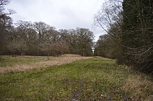
Sheephouse Wood
| Site of Special Scientific Interest | |
 | |
| Location | Buckinghamshire |
|---|---|
| Grid reference | SP703235 |
| Interest | Biological |
| Area | 56.9 hectares |
| Notification | 1986 |
| Location map | Magic Map |
Sheephouse Wood is a 56.9-hectare (141-acre) biological Site of Special Scientific Interest east of Charndon in Buckinghamshire.[1][2]
The site has ancient pedunculate oak woodland with diverse ground flora, typical breeding birds and some uncommon invertebrates. It is located on very poorly drained Oxford clay in the Vale of Aylesbury, and there are many small streams. Much of the woods have been woodland has been coppiced. Wet areas have maple and ash. The ground flora is dominated by brambles and bluebells. Invertebrates include the rare black hairstreak butterfly and ground-hopper tetrix subulata.[1]
There is access by footpaths from Calvert. Some areas have notices: "No public right of way: nature conservation area".
The former Great Central Main Line cuts through the southwestern edge of the wood. The alignment is still in use for freight. 1.4 hectares of woodland at the southwestern edge of the site will be lost with the construction of High Speed 2, which will pass adjacent to the existing railway.[3]
The new railway line will be covered by a structure in order to protect bats from passing trains. In November 2024, the cost of the structure was reported as £100 million.[4]
References
[edit]- ^ a b "Sheephouse Wood citation" (PDF). Sites of Special Scientific Interest. Natural England. Archived from the original (PDF) on 4 March 2016. Retrieved 20 March 2016.
- ^ "Map of Sheephouse Wood". Sites of Special Scientific Interest. Natural England. Retrieved 20 March 2016.
- ^ https://assets.publishing.service.gov.uk/government/uploads/system/uploads/attachment_data/file/664737/hs2_phase_one_ancient_woodland_strategy.pdf [bare URL PDF]
- ^ "£100m cost for HS2 bat safety 'shed' in Buckinghamshire". BBC News. 2024-11-07. Retrieved 2024-11-07.
