
She'ar Yashuv
She'ar Yashuv
שְׁאָר יָשׁוּב | |
|---|---|
 | |
 She'ar Yashuv | |
| Coordinates: 33°13′35″N 35°38′48″E / 33.22639°N 35.64667°E | |
| Country | Israel |
| District | Northern |
| Council | Mevo'ot HaHermon |
| Affiliation | HaOved HaTzioni |
| Founded | 1940 |
| Founded by | HaNoar HaTzioni and HaOved HaTzioni members |
| Population (2022) | 649[1] |
She'ar Yashuv (Hebrew: שְׁאָר יָשׁוּב) is a moshav in northern Israel. Located in the Upper Galilee in the northeastern Hula Valley, it falls under the jurisdiction of Mevo'ot HaHermon Regional Council. In 2022 it had a population of 649.[1]
The moshav came to public awareness after the 1997 Israeli helicopter disaster, when two IDF helicopters collided in midair above the settlement, killing 73 people on board.
Name
[edit]The name "She'ar Yashuv" (Hebrew: שאר ישוב, lit. 'the remnant shall return/a few will return') is based on the eponymous son of the prophet Isaiah (see Isaiah 7:3).
History
[edit]She'ar Yashuv was first founded in February 1940 along with Beit Hillel as part of the Tower and Stockade system by 30 families from the HaNoar HaTzioni ("Zionist Youth") and HaOved HaTzioni ("Zionist Workers"). It was originally called Metzadat Ussishkin Gimel, lit. "Ussishkin Fortress (No.) 3", named after Menahem Ussishkin, before being renamed Aleh Reish ("Go Up, Take Possession"). The present name is taken from the Book of Isaiah 10:21 ("A remnant will return, (the remnant of Jacob)").
When the battles of the 1948 Arab–Israeli War ended and a ceasefire was declared at the end of 1948, most of the inhabitants abandoned the community because of artillery shells fired by Syria from Tel Azaziat, which overlooks the village from the east. In 1949 it was resettled by remnants of the original community. This time, by members of HaNoar HaTzioni from Hungary who survived the Holocaust and had come to Israel during the war. After the war it also gained some land that had belonged to the depopulated Palestinian village of al-Mansura.[2]
-
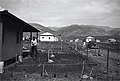
 She’ar Yeshuv March 1940
 -
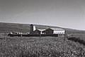
 She’ar Yashuv 1942, tower visible in distance
 -
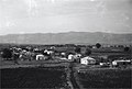 She’ar Yashuv 1946

-JNF034359.jpeg)

References
[edit]- ^ a b "Regional Statistics". Israel Central Bureau of Statistics. Retrieved 21 March 2024.
- ^ Khalidi, Walid (1992). All That Remains: The Palestinian Villages Occupied and Depopulated by Israel in 1948. Washington D.C.: Institute for Palestine Studies. p. 474. ISBN 0-88728-224-5.
| International | |
|---|---|
| National | |