Saturnia
Saturnia | |
|---|---|
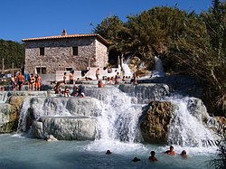
 Cascate del Mulino (Mill waterfalls) | |
| Coordinates: 42°39′59″N 11°30′15″E / 42.66639°N 11.50417°E | |
| Country | Italy |
| Region | |
| Province | Grosseto (GR) |
| Comune | Manciano |
| Elevation | 294 m (965 ft) |
| Population (2010)[1] | |
• Total | 280 |
| Time zone | UTC+1 (CET) |
| • Summer (DST) | UTC+2 (CEST) |
| Postal code | 58050 |
| Dialing code | 0564 |
Saturnia (Italian: [saˈturnja]) is a spa town in Tuscany in north-central Italy that has been inhabited since ancient times. It is a frazione of the comune of Manciano, in the province of Grosseto. Famous for the spa which gives it its name, its population is 280.[1]
Geography
[edit]It lies about 14 km (8.7 mi) from Manciano, 56 km (35 mi) from Grosseto, 37 km (23 mi) northeast of Orbetello and the coast and 115 km (71 mi) from Rome. Near the village, 800 L/s of sulphurous water at 37 °C gushes over a waterfall and down into a cascade of natural pools formed by the deposition of calcareous rock from evaporation of the water.
History
[edit]
Saturnia, which until 30BC was known as Aurinia,[2] takes its name from the Roman god Saturn (or Saturnus). Legend has it that he grew tired of the constant wars of humans, and sent a thunderbolt to earth that created a magic spring of warm sulphurous water which would pacify mankind.
Dionysius of Halicarnassus lists Saturnia as one of the towns first occupied by the Pelasgi and then by the Etruscan civilization. A Roman colony arrived in 183 BC, but little is known about it other than the fact that it was a prefecture. There are still remains of the city walls, in the polygonal style, which contain Roman gateways. Roman remains have also been discovered within the town, and remains of tombs outside. These tombs were originally covered by tumuli, which have now disappeared, so that George Dennis, author of Cities and Cemeteries of Etruria, mistook them for megalithic remains.
In 1300, Saturnia became the hideout of outlaws and was razed to the ground by the Sienese. Forgotten for several centuries, Saturnia was rediscovered in the late 19th century when the land around the spring was drained and a spa built. Thousands of visitors come to bathe in the waters to this day.
Main sights
[edit]Church of Santa Maria Maddalena
[edit]
The Church of Santa Maria Maddalena is the main church in Saturnia. The earliest historical records related to the church date back to 1188, but the current building is due to a restoration of 1933.
The church holds the famous Madonna and Child fresco attributed to Benvenuto di Giovanni at the end of the 15th century.
Terme di Saturnia
[edit]Other sights
[edit]- Rocca Aldobrandesca
- Saturnia Walls (Mura di Saturnia)
- Roman Gate (Porta Romana)
- Archaeological museum
Gallery
[edit]-
Saturnia hot stream
-
Village square
-
Roman gate on the Via Clodia
-
Gorello waterfall
See also
[edit]- Similar places
- Geothermal areas of Yellowstone in the USA
- Pamukkale in Turkey
- Huanglong Scenic and Historic Interest Area in China
- Badab-e Surt in Iran[3]
- Pink and White Terraces in New Zealand were similar travertine terraces until they were covered in a volcanic eruption. The Pink and White Terrace locations were finally mapped by researchers in 2017.[4][5]
References
[edit]- ^ a b (in Italian) Info on italia.indettaglio.it
- ^ Harris, W. V. (2020-11-14). "*Aurinia/Saturnia: a Pleiades place resource". Pleiades: a gazetteer of past places. DARMC, R. Talbert, Brady Kiesling, Sean Gillies, Jeffrey Becker, Tom Elliott. Retrieved 2022-11-15.
- ^ Badab-e Surt on WikiMapia
- ^ Bunn, Rex; Nolden, Sascha (2017-06-07). "Forensic cartography with Hochstetter's 1859 Pink and White Terraces survey: Te Otukapuarangi and Te Tarata". Journal of the Royal Society of New Zealand. 48: 39–56. doi:10.1080/03036758.2017.1329748. ISSN 0303-6758. S2CID 134907436.
- ^ Bunn and Nolden, Rex and Sascha (December 2016). "Te Tarata and Te Otukapuarangi: Reverse engineering Hochstetter's Lake Rotomahana Survey to map the Pink and White Terrace locations". Journal of New Zealand Studies. NS23: 37–53.
- This article incorporates text from a publication now in the public domain: Chisholm, Hugh, ed. (1911). "Saturnia". Encyclopædia Britannica. Vol. 24 (11th ed.). Cambridge University Press. p. 233.


